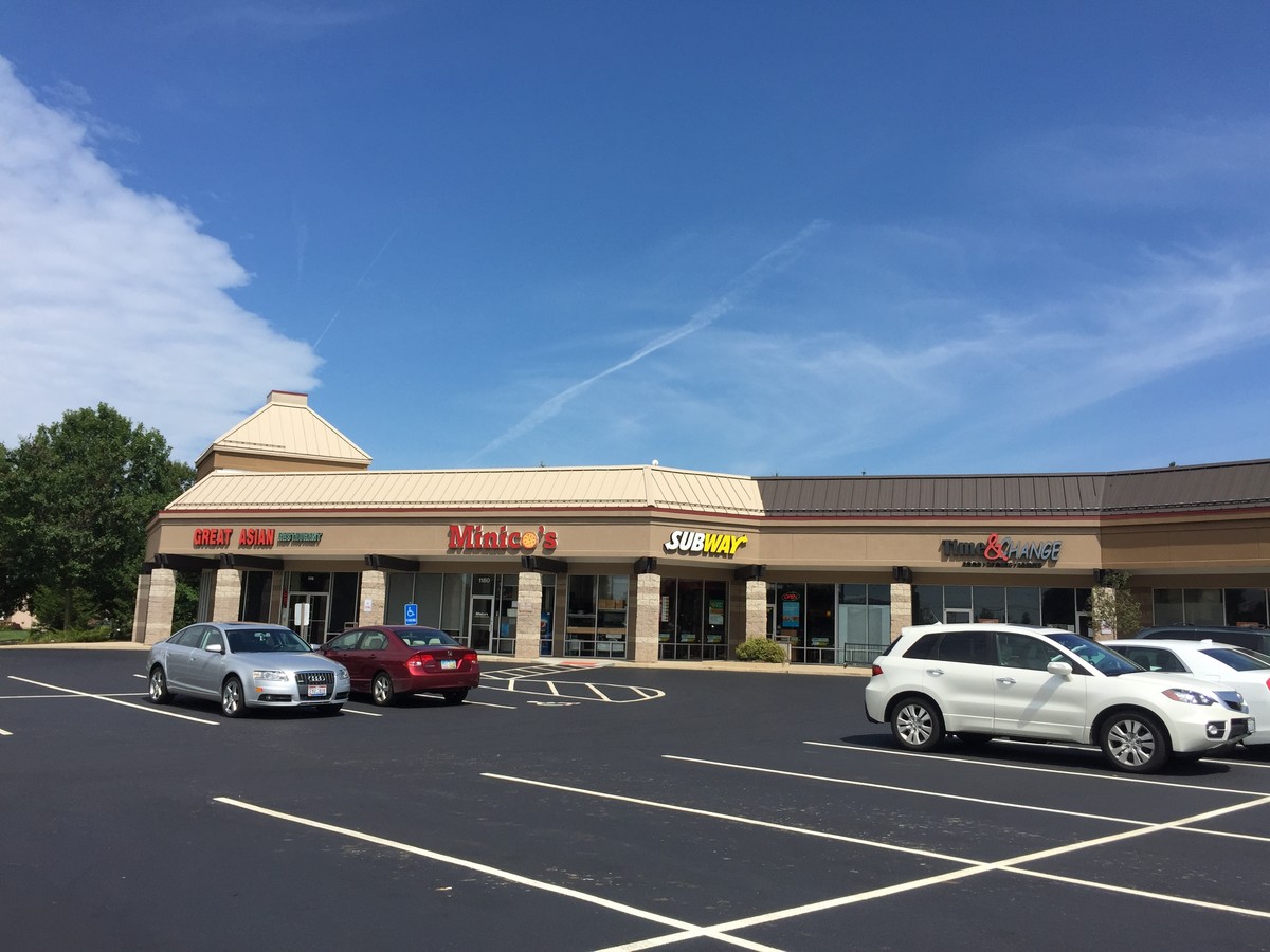
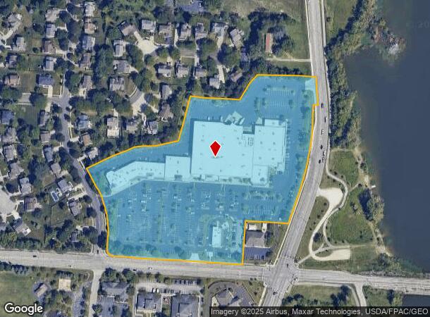
Property Record
275 N Sunbury Rd, Westerville, OH 43081


NEARBY LISTINGS FOR SALE OR LEASE
Property Detail
275 N Sunbury Rd
Columbus, OH
United States Military Lands
317-434-06-092-000
LANDS 17 3 4 12
Regionalshoppingcenterormallwithanchorstore
Delaware
ARE
Ohio
39041C0269K
12
2023
11.56 AC
2023
Outlying Delaware County
007193
Columbus
112,930 SF
DEMOGRAPHICS near 275 N Sunbury Rd
1 Mile
3 Mile
5 Mile
2024 Total Population
5,102
53,082
151,615
2029 Population
5,357
56,051
157,342
Pop Growth 2024-2029
+ 5.00%
+ 5.59%
+ 3.78%
Average Age
43
42
40
2024 Total Households
1,896
20,399
61,761
HH Growth 2024-2029
+ 5.38%
+ 5.60%
+ 3.52%
Median Household Inc
$127,418
$107,446
$91,442
Avg Household Size
2.60
2.50
2.40
2024 Avg HH Vehicles
2.00
2.00
2.00
Median Home Value
$342,043
$323,651
$301,153
Median Year Built
1989
1990
1991
Nearby Places
- Restaurants
- Banks
- Shops
- Fitness
- Groceries
PUBLIC TRANSPORTATION
AIRPORT
John Glenn Columbus International
DRIVE
WALK
Distance
John Glenn Columbus International
20 min
11.7 mi
Rickenbacker International
DRIVE
WALK
Distance
Rickenbacker International
39 min
27.1 mi
Freight Ports
Port of Toledo
DRIVE
WALK
Distance
Port of Toledo
177 min
139.0 mi
SALE & LEASE HISTORY
LISTING DATE
SALE/LEASE

Sep 26, 2016
For Lease
Sep 25, 2016
For Lease
Sep 20, 2017
For Lease
Nearby Properties
Address
Land Use
TOTAL SIZE
Lot Size
Zoning
Address
Land Use
TOTAL SIZE
Lot Size
Zoning
426,653 SF
19.43 AC
Address
Land Use
TOTAL SIZE
Lot Size
Zoning
446,516 SF
95.88 AC
Address
Land Use
TOTAL SIZE
Lot Size
Zoning
320,022 SF
37.14 AC
Address
Land Use
TOTAL SIZE
Lot Size
Zoning
159,315 SF
13.25 AC
Address
Land Use
TOTAL SIZE
Lot Size
Zoning
218,891 SF
19.56 AC
Address
Land Use
TOTAL SIZE
Lot Size
Zoning
3,263 SF
989.66 AC
Address
Land Use
TOTAL SIZE
Lot Size
Zoning
877,131 SF
36.29 AC
Address
Land Use
TOTAL SIZE
Lot Size
Zoning
171,084 SF
16.30 AC
Address
Land Use
TOTAL SIZE
Lot Size
Zoning
137,489 SF
14.73 AC
Address
Land Use
TOTAL SIZE
Lot Size
Zoning
236,681 SF
7.83 AC
Address
Land Use
TOTAL SIZE
Lot Size
Zoning
100,848 SF
9.72 AC
Address
Land Use
TOTAL SIZE
Lot Size
Zoning
140,162 SF
34.63 AC
Address
Land Use
TOTAL SIZE
Lot Size
Zoning
28,068 SF
22.61 AC
Address
Land Use
TOTAL SIZE
Lot Size
Zoning
27,978 SF
11.35 AC
Address
Land Use
TOTAL SIZE
Lot Size
Zoning
175,042 SF
8.10 AC
Address
Land Use
TOTAL SIZE
Lot Size
Zoning
189,276 SF
16.25 AC
Address
Land Use
TOTAL SIZE
Lot Size
Zoning
215,003 SF
22.42 AC
Address
Land Use
TOTAL SIZE
Lot Size
Zoning
110,583 SF
12.46 AC
Address
Land Use
TOTAL SIZE
Lot Size
Zoning
79,247 SF
13.20 AC
Address
Land Use
TOTAL SIZE
Lot Size
Zoning
136,567 SF
12.48 AC
Address
Land Use
TOTAL SIZE
Lot Size
Zoning
60,588 SF
4.94 AC
Address
Land Use
TOTAL SIZE
Lot Size
Zoning
65,163 SF
7.04 AC
Address
Land Use
TOTAL SIZE
Lot Size
Zoning
83,448 SF
4.89 AC
Address
Land Use
TOTAL SIZE
Lot Size
Zoning
71,451 SF
22.62 AC
Address
Land Use
TOTAL SIZE
Lot Size
Zoning
58,230 SF
2.84 AC
Address
Land Use
TOTAL SIZE
Lot Size
Zoning
166,320 SF
12.10 AC
Address
Land Use
TOTAL SIZE
Lot Size
Zoning
46,008 SF
3.56 AC
Address
Land Use
TOTAL SIZE
Lot Size
Zoning
105,087 SF
5.75 AC
Address
Land Use
TOTAL SIZE
Lot Size
Zoning
190,644 SF
15.15 AC
Address
Land Use
TOTAL SIZE
Lot Size
Zoning
38,273 SF
10.04 AC
The World's #1 Commercial Real Estate Marketplace
Connect with us
© 2025 CoStar Group
The information above has been obtained from sources believed reliable. While we do not doubt its accuracy we have not verified it and make no guarantee, warranty or representation about it. It is your responsibility to independently confirm its accuracy and completeness. Any projections, opinions, assumptions, or estimates used are for example only and do not represent the current or future performance of the property. The value of this transaction to you depends on tax and other factors which should be evaluated by your tax, financial, and legal advisors. You and your advisors should conduct a careful, independent investigation of the property to determine to your satisfaction the suitability of the property for your needs.