Property Record
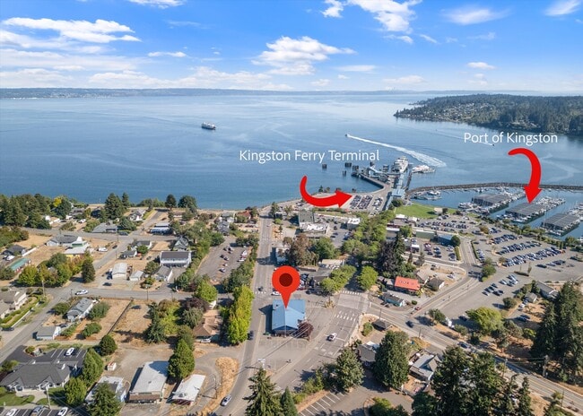
11212 Ne State Highway 104, Kingston, WA 98346


NEARBY LISTINGS FOR SALE OR LEASE
Property Detail
11212 Ne State Highway 104
Bremerton-Silverdale, WA
The Town Of Kingston
4316-032-001-00-03
LOTS 1, 2 AND 3, BLOCK 32, MAP OF THE TOWN OF KINGSTON, AS PER PLAT RECORDED IN VOLUME 1 OF PLATS, PAGE 39, RECORDS OF KITSAP COUNTY, WASHINGTON; EXCEPT THAT PORTION LYING WITHIN STATE HIGHWAY NO. 21; TOGETHER WITH THAT PORTION OF VACATED IOWA AVENUE
Restaurantbuilding
Kitsap
X
Washington
53033C0015H
1,2,3
2025
0.25 AC
2026
North Kitsap County
090102
Bremerton/Silverdale
3,392 SF
DEMOGRAPHICS near 11212 Ne State Highway 104
1 Mile
3 Mile
5 Mile
2024 Total Population
2,379
5,544
13,006
2029 Population
2,322
5,399
12,605
Pop Growth 2024-2029
(2.40%)
(2.62%)
(3.08%)
Average Age
45
46
45
2024 Total Households
998
2,297
5,207
HH Growth 2024-2029
(2.40%)
(2.57%)
(3.03%)
Median Household Inc
$101,742
$99,889
$96,129
Avg Household Size
2.30
2.30
2.40
2024 Avg HH Vehicles
2.00
2.00
2.00
Median Home Value
$661,885
$676,572
$608,529
Median Year Built
1992
1990
1988
Nearby Places
Map Layers
Map Styles
 Street
 Aerial
- Restaurants
- Banks
- Shops
- Fitness
- Groceries
PUBLIC TRANSPORTATION
AIRPORT
Seattle Paine Field International
DRIVE
WALK
Distance
Seattle Paine Field International
50 min
17.3 mi
Seattle-Tacoma International
DRIVE
WALK
Distance
Seattle-Tacoma International
75 min
37.1 mi
Freight Ports
Port of Everett
DRIVE
WALK
Distance
Port of Everett
61 min
25.3 mi
SALE & LEASE HISTORY
LISTING DATE
SALE/LEASE

Aug 28, 2024
For Sale
Nearby Properties
Address
Land Use
TOTAL SIZE
Lot Size
Zoning
Address
Land Use
TOTAL SIZE
Lot Size
Zoning
72,735 SF
5.72 AC
UH
Address
Land Use
TOTAL SIZE
Lot Size
Zoning
52,060 SF
15.70 AC
RR
Address
Land Use
TOTAL SIZE
Lot Size
Zoning
55.02 AC
RRUCR
Address
Land Use
TOTAL SIZE
Lot Size
Zoning
41,892 SF
4.58 AC
NC
Address
Land Use
TOTAL SIZE
Lot Size
Zoning
33,232 SF
3.44 AC
C
Address
Land Use
TOTAL SIZE
Lot Size
Zoning
29,570 SF
4.89 AC
UL
Address
Land Use
TOTAL SIZE
Lot Size
Zoning
22,879 SF
2.99 AC
C
Address
Land Use
TOTAL SIZE
Lot Size
Zoning
7,092 SF
0.90 AC
UM
Address
Land Use
TOTAL SIZE
Lot Size
Zoning
15,414 SF
1.49 AC
UM
Address
Land Use
TOTAL SIZE
Lot Size
Zoning
17,664 SF
2.11 AC
UL
Address
Land Use
TOTAL SIZE
Lot Size
Zoning
18,187 SF
2.16 AC
NC
Address
Land Use
TOTAL SIZE
Lot Size
Zoning
9,933 SF
0.98 AC
NC
Address
Land Use
TOTAL SIZE
Lot Size
Zoning
9,750 SF
1.11 AC
NC
Address
Land Use
TOTAL SIZE
Lot Size
Zoning
30,755 SF
1.15 AC
NC
Address
Land Use
TOTAL SIZE
Lot Size
Zoning
9,064 SF
15.07 AC
RR
Address
Land Use
TOTAL SIZE
Lot Size
Zoning
6,450 SF
0.90 AC
NC
Address
Land Use
TOTAL SIZE
Lot Size
Zoning
14,436 SF
1.18 AC
C
Address
Land Use
TOTAL SIZE
Lot Size
Zoning
2,705 SF
1.59 AC
C
Address
Land Use
TOTAL SIZE
Lot Size
Zoning
5,027 SF
16.56 AC
RR
Address
Land Use
TOTAL SIZE
Lot Size
Zoning
2,654 SF
0.76 AC
C
Address
Land Use
TOTAL SIZE
Lot Size
Zoning
10,979 SF
0.38 AC
UVC
Address
Land Use
TOTAL SIZE
Lot Size
Zoning
4,317 SF
2 AC
RP
Address
Land Use
TOTAL SIZE
Lot Size
Zoning
4,200 SF
1.32 AC
NC
Address
Land Use
TOTAL SIZE
Lot Size
Zoning
12,325 SF
2.86 AC
C
Address
Land Use
TOTAL SIZE
Lot Size
Zoning
5,138 SF
13.15 AC
RR
Address
Land Use
TOTAL SIZE
Lot Size
Zoning
7,520 SF
0.39 AC
C
Address
Land Use
TOTAL SIZE
Lot Size
Zoning
1,980 SF
0.85 AC
NC
Address
Land Use
TOTAL SIZE
Lot Size
Zoning
12,350 SF
0.71 AC
C
Address
Land Use
TOTAL SIZE
Lot Size
Zoning
4,639 SF
0.69 AC
C
Address
Land Use
TOTAL SIZE
Lot Size
Zoning
7,094 SF
0.48 AC
UVC
The World's #1 Commercial Real Estate Marketplace
Connect with us
© 2026 CoStar Group
The information above has been obtained from sources believed reliable. While we do not doubt its accuracy we have not verified it and make no guarantee, warranty or representation about it. It is your responsibility to independently confirm its accuracy and completeness. Any projections, opinions, assumptions, or estimates used are for example only and do not represent the current or future performance of the property. The value of this transaction to you depends on tax and other factors which should be evaluated by your tax, financial, and legal advisors. You and your advisors should conduct a careful, independent investigation of the property to determine to your satisfaction the suitability of the property for your needs.