Property Record
1130 Helicopter Way, Central Point, OR 97502

NEARBY LISTINGS FOR SALE OR LEASE
Property Detail
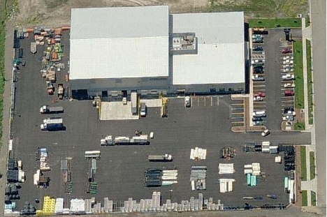
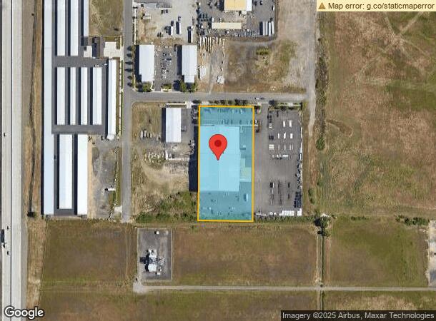
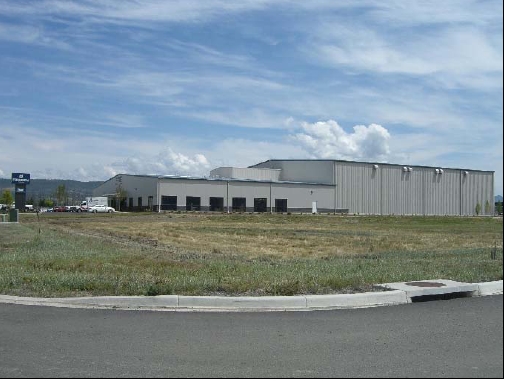
1130 Helicopter Way
10985254
Hover Heights
Industrialgeneral
Jackson
X
Oregon
41029C1788F
10,11
2023
2.34 AC
2024
Other Market Areas
001200
Medford, OR
43,092 SF
DEMOGRAPHICS near 1130 Helicopter Way
1 Mile
3 Mile
5 Mile
2024 Total Population
298
36,700
94,910
2029 Population
304
36,596
94,715
Pop Growth 2024-2029
+ 2.01%
(0.28%)
(0.21%)
Average Age
43
40
40
2024 Total Households
92
13,806
36,228
HH Growth 2024-2029
+ 2.17%
(0.33%)
(0.27%)
Median Household Inc
$85,119
$67,703
$64,088
Avg Household Size
2.90
2.60
2.50
2024 Avg HH Vehicles
3.00
2.00
2.00
Median Home Value
$331,666
$315,508
$325,137
Median Year Built
1984
1988
1982
Nearby Places
- Restaurants
- Banks
- Shops
- Fitness
- Groceries
PUBLIC TRANSPORTATION
AIRPORT
Rogue Valley International - Medford
DRIVE
WALK
Distance
Rogue Valley International - Medford
7 min
3.2 mi
Freight Ports
Port of Coos Bay, OR
DRIVE
WALK
Distance
Port of Coos Bay, OR
217 min
163.6 mi
Nearby Properties
Address
Land Use
TOTAL SIZE
Lot Size
Zoning
Address
Land Use
TOTAL SIZE
Lot Size
Zoning
291.02 AC
I-L
Address
Land Use
TOTAL SIZE
Lot Size
Zoning
249,867 SF
61.31 AC
SFR-4
Address
Land Use
TOTAL SIZE
Lot Size
Zoning
600,000 SF
18.27 AC
M-1
Address
Land Use
TOTAL SIZE
Lot Size
Zoning
11,180 SF
1.58 AC
MFR-20
Address
Land Use
TOTAL SIZE
Lot Size
Zoning
73.48 AC
GI
Address
Land Use
TOTAL SIZE
Lot Size
Zoning
88,434 SF
12.10 AC
I-L
Address
Land Use
TOTAL SIZE
Lot Size
Zoning
88.67 AC
I-L
Address
Land Use
TOTAL SIZE
Lot Size
Zoning
125,910 SF
14.29 AC
C-R
Address
Land Use
TOTAL SIZE
Lot Size
Zoning
136,756 SF
12.50 AC
C-R
Address
Land Use
TOTAL SIZE
Lot Size
Zoning
109,042 SF
7.06 AC
C-R
Address
Land Use
TOTAL SIZE
Lot Size
Zoning
77,232 SF
1.46 AC
MFR-20
Address
Land Use
TOTAL SIZE
Lot Size
Zoning
102,184 SF
5.82 AC
I-L
Address
Land Use
TOTAL SIZE
Lot Size
Zoning
116,000 SF
5.17 AC
MFR-30
Address
Land Use
TOTAL SIZE
Lot Size
Zoning
164,324 SF
7.40 AC
C-R
Address
Land Use
TOTAL SIZE
Lot Size
Zoning
98,547 SF
4.36 AC
I-L
Address
Land Use
TOTAL SIZE
Lot Size
Zoning
164,324 SF
6.42 AC
C-R
Address
Land Use
TOTAL SIZE
Lot Size
Zoning
45,406 SF
3.29 AC
MFR-15
Address
Land Use
TOTAL SIZE
Lot Size
Zoning
144,396 SF
10.67 AC
C-R
Address
Land Use
TOTAL SIZE
Lot Size
Zoning
54,823 SF
15.17 AC
I-L
Address
Land Use
TOTAL SIZE
Lot Size
Zoning
25.77 AC
GI
Address
Land Use
TOTAL SIZE
Lot Size
Zoning
32,614 SF
8.27 AC
M-1
Address
Land Use
TOTAL SIZE
Lot Size
Zoning
32,240 SF
20.24 AC
M-2
Address
Land Use
TOTAL SIZE
Lot Size
Zoning
103,936 SF
5.90 AC
MFR-20
Address
Land Use
TOTAL SIZE
Lot Size
Zoning
57,024 SF
2.47 AC
MFR-20
Address
Land Use
TOTAL SIZE
Lot Size
Zoning
100,000 SF
5.77 AC
I-G
Address
Land Use
TOTAL SIZE
Lot Size
Zoning
79,447 SF
6.69 AC
C-R
Address
Land Use
TOTAL SIZE
Lot Size
Zoning
92,750 SF
102.77 AC
I-L
Address
Land Use
TOTAL SIZE
Lot Size
Zoning
56,962 SF
2.71 AC
C-R
Address
Land Use
TOTAL SIZE
Lot Size
Zoning
98,688 SF
5.09 AC
MFR-30
Address
Land Use
TOTAL SIZE
Lot Size
Zoning
92,788 SF
4.85 AC
MFR-20
The World's #1 Commercial Real Estate Marketplace
Connect with us
© 2025 CoStar Group
The information above has been obtained from sources believed reliable. While we do not doubt its accuracy we have not verified it and make no guarantee, warranty or representation about it. It is your responsibility to independently confirm its accuracy and completeness. Any projections, opinions, assumptions, or estimates used are for example only and do not represent the current or future performance of the property. The value of this transaction to you depends on tax and other factors which should be evaluated by your tax, financial, and legal advisors. You and your advisors should conduct a careful, independent investigation of the property to determine to your satisfaction the suitability of the property for your needs.