Property Record
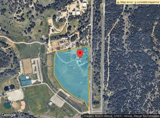
11301 Us Highway 281 N, Spring Branch, TX 78070
NEARBY LISTINGS FOR SALE OR LEASE
Property Detail
11301 Us Highway 281 N
74-0108-0012-05
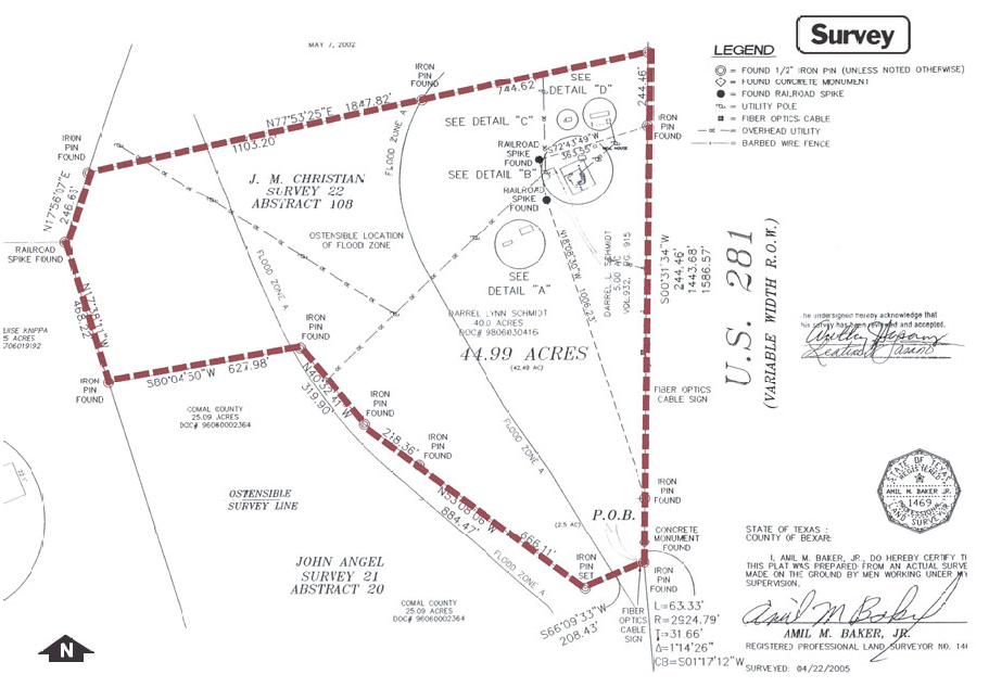
A-108 Sur- 22 J M Christian
Agriculturalland
A-108 SUR- 22 J M CHRISTIAN, ACRES 23.801
A
Comal
48259C0350F
Texas
2024
23.80 AC
2023
Comal County
310702
San Antonio
1,390 SF
San Antonio-New Braunfels, TX
DEMOGRAPHICS near 11301 Us Highway 281 N
1 Mile
3 Mile
5 Mile
2024 Total Population
335
5,388
13,489
2029 Population
457
7,379
18,472
Pop Growth 2024-2029
+ 36.42%
+ 36.95%
+ 36.94%
Average Age
41
40
43
2024 Total Households
116
1,923
5,001
HH Growth 2024-2029
+ 37.07%
+ 36.71%
+ 36.77%
Median Household Inc
$95,587
$72,272
$88,066
Avg Household Size
2.70
2.60
2.60
2024 Avg HH Vehicles
2.00
2.00
2.00
Median Home Value
$420,000
$382,050
$424,261
Median Year Built
2003
2000
2004
Nearby Places
- Restaurants
- Banks
- Shops
- Fitness
- Groceries
PUBLIC TRANSPORTATION
AIRPORT
San Antonio International
DRIVE
WALK
Distance
San Antonio International
33 min
27.5 mi
Freight Ports
Calhoun Port
DRIVE
WALK
Distance
Calhoun Port
207 min
170.1 mi
Nearby Properties
Address
Land Use
TOTAL SIZE
Lot Size
Zoning
Address
Land Use
TOTAL SIZE
Lot Size
Zoning
17,400 SF
3.76 AC
Address
Land Use
TOTAL SIZE
Lot Size
Zoning
9.46 AC
Address
Land Use
TOTAL SIZE
Lot Size
Zoning
7,148 SF
21.01 AC
Address
Land Use
TOTAL SIZE
Lot Size
Zoning
194.26 AC
Address
Land Use
TOTAL SIZE
Lot Size
Zoning
5,288 SF
133.02 AC
Address
Land Use
TOTAL SIZE
Lot Size
Zoning
180 SF
2.24 AC
Address
Land Use
TOTAL SIZE
Lot Size
Zoning
3,584 SF
10.54 AC
Address
Land Use
TOTAL SIZE
Lot Size
Zoning
21,200 SF
15.54 AC
Address
Land Use
TOTAL SIZE
Lot Size
Zoning
8,357 SF
15.47 AC
Address
Land Use
TOTAL SIZE
Lot Size
Zoning
9,760 SF
2.85 AC
Address
Land Use
TOTAL SIZE
Lot Size
Zoning
16,123 SF
1.79 AC
Address
Land Use
TOTAL SIZE
Lot Size
Zoning
10,186 SF
3 AC
Address
Land Use
TOTAL SIZE
Lot Size
Zoning
8,216 SF
3.47 AC
Address
Land Use
TOTAL SIZE
Lot Size
Zoning
12,362 SF
25.99 AC
Address
Land Use
TOTAL SIZE
Lot Size
Zoning
9,856 SF
1.90 AC
Address
Land Use
TOTAL SIZE
Lot Size
Zoning
2,800 SF
25.73 AC
Address
Land Use
TOTAL SIZE
Lot Size
Zoning
5,349 SF
2.07 AC
Address
Land Use
TOTAL SIZE
Lot Size
Zoning
9,036 SF
0.98 AC
Address
Land Use
TOTAL SIZE
Lot Size
Zoning
465 SF
16.03 AC
Address
Land Use
TOTAL SIZE
Lot Size
Zoning
Address
Land Use
TOTAL SIZE
Lot Size
Zoning
3,129 SF
5.46 AC
Address
Land Use
TOTAL SIZE
Lot Size
Zoning
8,270 SF
1.45 AC
Address
Land Use
TOTAL SIZE
Lot Size
Zoning
2,160 SF
13.79 AC
Address
Land Use
TOTAL SIZE
Lot Size
Zoning
Address
Land Use
TOTAL SIZE
Lot Size
Zoning
15.41 AC
Address
Land Use
TOTAL SIZE
Lot Size
Zoning
3,979 SF
16 AC
Address
Land Use
TOTAL SIZE
Lot Size
Zoning
5,450 SF
17.74 AC
Address
Land Use
TOTAL SIZE
Lot Size
Zoning
4,400 SF
2 AC
Address
Land Use
TOTAL SIZE
Lot Size
Zoning
400 SF
3.64 AC
The World's #1 Commercial Real Estate Marketplace
Connect with us
© 2025 CoStar Group
The information above has been obtained from sources believed reliable. While we do not doubt its accuracy we have not verified it and make no guarantee, warranty or representation about it. It is your responsibility to independently confirm its accuracy and completeness. Any projections, opinions, assumptions, or estimates used are for example only and do not represent the current or future performance of the property. The value of this transaction to you depends on tax and other factors which should be evaluated by your tax, financial, and legal advisors. You and your advisors should conduct a careful, independent investigation of the property to determine to your satisfaction the suitability of the property for your needs.