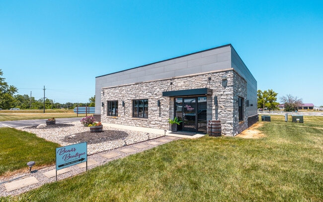
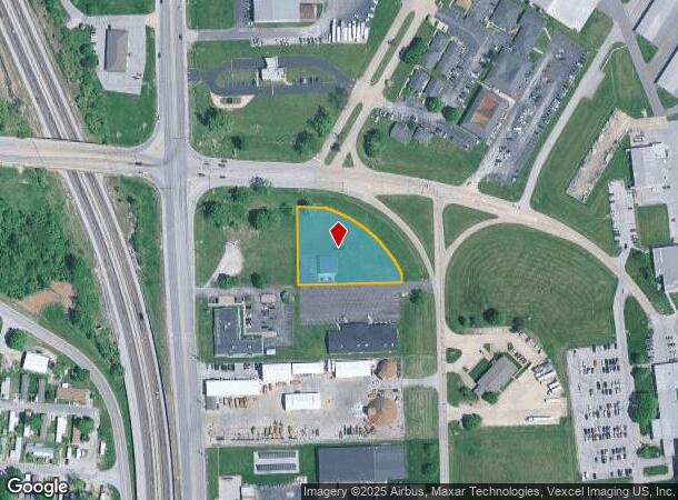
Property Record
Rt St, Bethalto, IL 62010

NEARBY LISTINGS FOR SALE OR LEASE
Property Detail
Rt St
St. Louis
Pratt Professional Park First Addn
St. Louis, MO-IL
PRATT PROFESSIONAL PARK 1ST ADDN OUTLOT B 287.97 X 275.02 IRR
19-2-08-13-01-101-023
Madison
Storesoffices
Illinois
2024
b
2024
1.82 AC
401721
NE Metro Illinois
2,025 SF
DEMOGRAPHICS near Rt St
1 Mile
3 Mile
5 Mile
2024 Total Population
2,488
32,716
50,318
2029 Population
2,427
32,248
49,815
Pop Growth 2024-2029
(2.45%)
(1.43%)
(1.00%)
Average Age
43
42
41
2024 Total Households
1,069
14,048
21,546
HH Growth 2024-2029
(2.43%)
(1.48%)
(1.04%)
Median Household Inc
$73,339
$63,034
$59,550
Avg Household Size
2.30
2.30
2.30
2024 Avg HH Vehicles
2.00
2.00
2.00
Median Home Value
$144,412
$126,956
$115,505
Median Year Built
1959
1960
1959
Nearby Places
Map Layers
Map Styles
 Street
 Aerial
- Restaurants
- Banks
- Shops
- Fitness
- Groceries
PUBLIC TRANSPORTATION
COMMUTER RAIL
DRIVE
WALK
Distance
16 min
7.7 mi
AIRPORT
St Louis Lambert International
DRIVE
WALK
Distance
St Louis Lambert International
39 min
26.0 mi
Scott AFB/Midamerica St Louis
DRIVE
WALK
Distance
Scott AFB/Midamerica St Louis
57 min
38.5 mi
SALE & LEASE HISTORY
LISTING DATE
SALE/LEASE

Jul 22, 2024
For Sale
Aug 05, 2024
For Lease
Nearby Properties
Address
Land Use
TOTAL SIZE
Lot Size
Zoning
Address
Land Use
TOTAL SIZE
Lot Size
Zoning
Address
Land Use
TOTAL SIZE
Lot Size
Zoning
215,635 SF
23.08 AC
Address
Land Use
TOTAL SIZE
Lot Size
Zoning
Address
Land Use
TOTAL SIZE
Lot Size
Zoning
58,990 SF
11.77 AC
Address
Land Use
TOTAL SIZE
Lot Size
Zoning
242.45 AC
Address
Land Use
TOTAL SIZE
Lot Size
Zoning
147,365 SF
1.91 AC
Address
Land Use
TOTAL SIZE
Lot Size
Zoning
37,533 SF
7.80 AC
Address
Land Use
TOTAL SIZE
Lot Size
Zoning
66,140 SF
9.79 AC
Address
Land Use
TOTAL SIZE
Lot Size
Zoning
62,859 SF
12 AC
Address
Land Use
TOTAL SIZE
Lot Size
Zoning
58,900 SF
2.05 AC
Address
Land Use
TOTAL SIZE
Lot Size
Zoning
46,642 SF
10.50 AC
Address
Land Use
TOTAL SIZE
Lot Size
Zoning
75,312 SF
4.35 AC
Address
Land Use
TOTAL SIZE
Lot Size
Zoning
4,800 SF
39.15 AC
Address
Land Use
TOTAL SIZE
Lot Size
Zoning
20,000 SF
10.81 AC
Address
Land Use
TOTAL SIZE
Lot Size
Zoning
22,902 SF
408.34 AC
Address
Land Use
TOTAL SIZE
Lot Size
Zoning
55,020 SF
2.85 AC
Address
Land Use
TOTAL SIZE
Lot Size
Zoning
21,200 SF
4 AC
Address
Land Use
TOTAL SIZE
Lot Size
Zoning
10,236 SF
5 AC
Address
Land Use
TOTAL SIZE
Lot Size
Zoning
38,517 SF
4.10 AC
Address
Land Use
TOTAL SIZE
Lot Size
Zoning
16,349 SF
3 AC
Address
Land Use
TOTAL SIZE
Lot Size
Zoning
116,500 SF
11.72 AC
Address
Land Use
TOTAL SIZE
Lot Size
Zoning
29,491 SF
2 AC
Address
Land Use
TOTAL SIZE
Lot Size
Zoning
17,760 SF
2.72 AC
Address
Land Use
TOTAL SIZE
Lot Size
Zoning
26,320 SF
4.82 AC
Address
Land Use
TOTAL SIZE
Lot Size
Zoning
21,614 SF
0.62 AC
Address
Land Use
TOTAL SIZE
Lot Size
Zoning
4,380 SF
8.25 AC
Address
Land Use
TOTAL SIZE
Lot Size
Zoning
9,000 SF
13.68 AC
Address
Land Use
TOTAL SIZE
Lot Size
Zoning
111,616 SF
10 AC
Address
Land Use
TOTAL SIZE
Lot Size
Zoning
21,258 SF
5.26 AC
Address
Land Use
TOTAL SIZE
Lot Size
Zoning
41,203 SF
The World's #1 Commercial Real Estate Marketplace
Connect with us
© 2026 CoStar Group
The information above has been obtained from sources believed reliable. While we do not doubt its accuracy we have not verified it and make no guarantee, warranty or representation about it. It is your responsibility to independently confirm its accuracy and completeness. Any projections, opinions, assumptions, or estimates used are for example only and do not represent the current or future performance of the property. The value of this transaction to you depends on tax and other factors which should be evaluated by your tax, financial, and legal advisors. You and your advisors should conduct a careful, independent investigation of the property to determine to your satisfaction the suitability of the property for your needs.