Property Record
1135 Bankhead Hwy, Carrollton, GA 30116
NEARBY LISTINGS FOR SALE OR LEASE
Property Detail
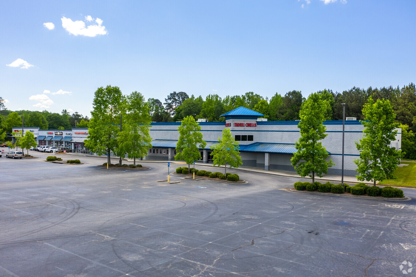
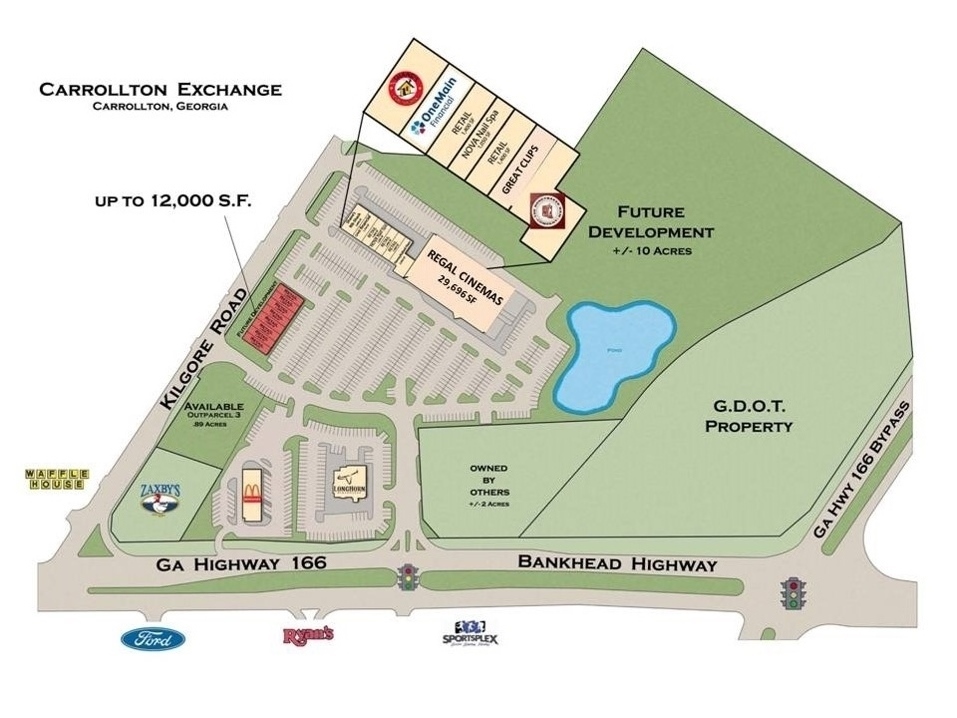
1135 Bankhead Hwy
C05-0310077
COMM BLDG/1.58AC BANKHEAD HWY
Regionalshoppingcenterormallwithanchorstore
Carroll
X
Georgia
13045C0258D
1.58 AC
2024
Villa Rica/W Outlying
2024
Atlanta
910705
Atlanta-Sandy Springs-Roswell, GA
12,700 SF
DEMOGRAPHICS near 1135 Bankhead Hwy
1 Mile
3 Mile
5 Mile
2024 Total Population
1,796
23,012
47,669
2029 Population
1,974
25,545
52,912
Pop Growth 2024-2029
+ 9.91%
+ 11.01%
+ 11.00%
Average Age
38
37
36
2024 Total Households
717
8,589
17,120
HH Growth 2024-2029
+ 10.04%
+ 11.06%
+ 11.20%
Median Household Inc
$44,223
$49,522
$48,342
Avg Household Size
2.40
2.60
2.60
2024 Avg HH Vehicles
1.00
2.00
2.00
Median Home Value
$167,195
$185,601
$214,443
Median Year Built
1984
1984
1987
Nearby Places
- Restaurants
- Banks
- Shops
- Fitness
- Groceries
SALE & LEASE HISTORY
LISTING DATE
SALE/LEASE

Sep 25, 2016
For Lease
May 19, 2017
For Lease
Nearby Properties
Address
Land Use
TOTAL SIZE
Lot Size
Zoning
Address
Land Use
TOTAL SIZE
Lot Size
Zoning
50,000 SF
28.63 AC
HS
Address
Land Use
TOTAL SIZE
Lot Size
Zoning
106,769 SF
11.26 AC
HS
Address
Land Use
TOTAL SIZE
Lot Size
Zoning
1,542,912 SF
118.16 AC
M2
Address
Land Use
TOTAL SIZE
Lot Size
Zoning
152,962 SF
108.90 AC
OI
Address
Land Use
TOTAL SIZE
Lot Size
Zoning
134,113 SF
2.80 AC
OI
Address
Land Use
TOTAL SIZE
Lot Size
Zoning
73,900 SF
10.57 AC
C2
Address
Land Use
TOTAL SIZE
Lot Size
Zoning
354,354 SF
51.15 AC
I
Address
Land Use
TOTAL SIZE
Lot Size
Zoning
56,458 SF
21.87 AC
R3
Address
Land Use
TOTAL SIZE
Lot Size
Zoning
19,960 SF
0.53 AC
HS
Address
Land Use
TOTAL SIZE
Lot Size
Zoning
276,510 SF
6.78 AC
M1
Address
Land Use
TOTAL SIZE
Lot Size
Zoning
44,708 SF
9.92 AC
RESIDENTIA
Address
Land Use
TOTAL SIZE
Lot Size
Zoning
90,800 SF
10.89 AC
C2
Address
Land Use
TOTAL SIZE
Lot Size
Zoning
28,554 SF
0.74 AC
002
Address
Land Use
TOTAL SIZE
Lot Size
Zoning
42,905 SF
9.76 AC
002
Address
Land Use
TOTAL SIZE
Lot Size
Zoning
19,840 SF
10.37 AC
R2
Address
Land Use
TOTAL SIZE
Lot Size
Zoning
30,985 SF
3.24 AC
HS
Address
Land Use
TOTAL SIZE
Lot Size
Zoning
3.23 AC
C1
Address
Land Use
TOTAL SIZE
Lot Size
Zoning
45,480 SF
62.18 AC
R20
Address
Land Use
TOTAL SIZE
Lot Size
Zoning
130,493 SF
14.34 AC
C2
Address
Land Use
TOTAL SIZE
Lot Size
Zoning
90,485 SF
10.35 AC
C2
Address
Land Use
TOTAL SIZE
Lot Size
Zoning
163,568 SF
16.80 AC
C2
Address
Land Use
TOTAL SIZE
Lot Size
Zoning
13,299 SF
226.96 AC
R20
Address
Land Use
TOTAL SIZE
Lot Size
Zoning
58,085 SF
4.10 AC
M1
Address
Land Use
TOTAL SIZE
Lot Size
Zoning
74,920 SF
8.19 AC
C2
Address
Land Use
TOTAL SIZE
Lot Size
Zoning
29,561 SF
5.89 AC
C2
Address
Land Use
TOTAL SIZE
Lot Size
Zoning
50,300 SF
6.48 AC
R2
Address
Land Use
TOTAL SIZE
Lot Size
Zoning
40,000 SF
3.12 AC
C1
Address
Land Use
TOTAL SIZE
Lot Size
Zoning
100.74 AC
PUD
Address
Land Use
TOTAL SIZE
Lot Size
Zoning
31,588 SF
2.39 AC
OI
Address
Land Use
TOTAL SIZE
Lot Size
Zoning
63,888 SF
8.40 AC
I
The World's #1 Commercial Real Estate Marketplace
Connect with us
© 2025 CoStar Group
The information above has been obtained from sources believed reliable. While we do not doubt its accuracy we have not verified it and make no guarantee, warranty or representation about it. It is your responsibility to independently confirm its accuracy and completeness. Any projections, opinions, assumptions, or estimates used are for example only and do not represent the current or future performance of the property. The value of this transaction to you depends on tax and other factors which should be evaluated by your tax, financial, and legal advisors. You and your advisors should conduct a careful, independent investigation of the property to determine to your satisfaction the suitability of the property for your needs.