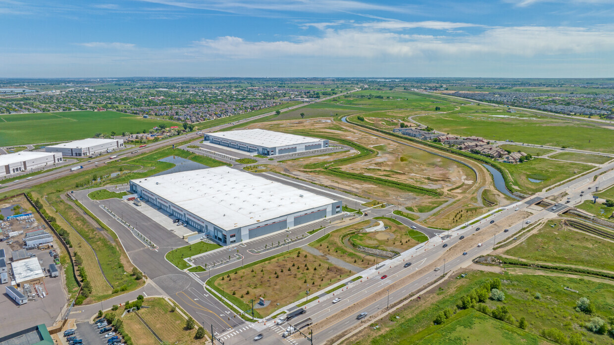
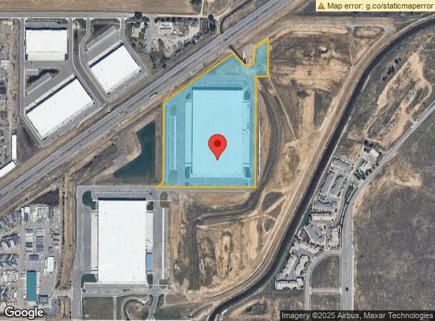
Property Record
11351 E 104Th Ave, Henderson, CO 80640
Current Lease Availabilities
NEARBY LISTINGS FOR SALE OR LEASE
Property Detail
11351 E 104Th Ave
Denver
104Th Commerce Park Subd
Denver-Aurora-Lakewood, CO
104TH COMMERCE PARK SUBD LOT 3
1721-11-3-01-003
Adams
Warehouse
Colorado
2023
3
2024
17.66 AC
008557
DIA
298,200 SF
DEMOGRAPHICS near 11351 E 104Th Ave
1 Mile
3 Mile
5 Mile
2024 Total Population
4,157
27,759
123,452
2029 Population
4,337
29,361
129,200
Pop Growth 2024-2029
+ 4.33%
+ 5.77%
+ 4.66%
Average Age
34
34
35
2024 Total Households
1,267
8,556
39,471
HH Growth 2024-2029
+ 4.42%
+ 5.84%
+ 4.70%
Median Household Inc
$109,738
$113,775
$104,300
Avg Household Size
3.30
3.20
3.10
2024 Avg HH Vehicles
2.00
2.00
2.00
Median Home Value
$444,291
$448,404
$442,544
Median Year Built
2006
2007
2002
Nearby Places
- Restaurants
- Banks
- Shops
- Fitness
- Groceries
PUBLIC TRANSPORTATION
COMMUTER RAIL
Thornton Crossroads - 104Th Station Track 1 (Union Station to Eastlake & 124th Station - Regional Transportation District)
DRIVE
WALK
Distance
Thornton Crossroads - 104Th Station Track 1 (Union Station to Eastlake & 124th Station - Regional Transportation District)
14 min
9.8 mi
AIRPORT
Denver International
DRIVE
WALK
Distance
Denver International
22 min
16.8 mi
Freight Ports
Tulsa Port Of Catoosa
DRIVE
WALK
Distance
Tulsa Port Of Catoosa
729 min
710.9 mi
Nearby Properties
Address
Land Use
TOTAL SIZE
Lot Size
Zoning
Address
Land Use
TOTAL SIZE
Lot Size
Zoning
358,386 SF
76.08 AC
Address
Land Use
TOTAL SIZE
Lot Size
Zoning
8,556 SF
382.73 AC
A3
Address
Land Use
TOTAL SIZE
Lot Size
Zoning
276,395 SF
26.43 AC
A3
Address
Land Use
TOTAL SIZE
Lot Size
Zoning
549,866 SF
33.82 AC
Address
Land Use
TOTAL SIZE
Lot Size
Zoning
631.25 AC
A3
Address
Land Use
TOTAL SIZE
Lot Size
Zoning
624.70 AC
A3
Address
Land Use
TOTAL SIZE
Lot Size
Zoning
624.02 AC
A3
Address
Land Use
TOTAL SIZE
Lot Size
Zoning
616.10 AC
A3
Address
Land Use
TOTAL SIZE
Lot Size
Zoning
330,176 SF
17.12 AC
Address
Land Use
TOTAL SIZE
Lot Size
Zoning
328,674 SF
47.13 AC
Address
Land Use
TOTAL SIZE
Lot Size
Zoning
272,800 SF
16.44 AC
Address
Land Use
TOTAL SIZE
Lot Size
Zoning
258,279 SF
70.11 AC
I2
Address
Land Use
TOTAL SIZE
Lot Size
Zoning
172,816 SF
59.89 AC
Address
Land Use
TOTAL SIZE
Lot Size
Zoning
64,750 SF
11.91 AC
Address
Land Use
TOTAL SIZE
Lot Size
Zoning
158,001 SF
20.40 AC
Address
Land Use
TOTAL SIZE
Lot Size
Zoning
199,500 SF
15.03 AC
Address
Land Use
TOTAL SIZE
Lot Size
Zoning
86,225 SF
13.55 AC
Address
Land Use
TOTAL SIZE
Lot Size
Zoning
204,000 SF
9.96 AC
Address
Land Use
TOTAL SIZE
Lot Size
Zoning
96,628 SF
4.34 AC
Address
Land Use
TOTAL SIZE
Lot Size
Zoning
76,279 SF
25.01 AC
Address
Land Use
TOTAL SIZE
Lot Size
Zoning
121,275 SF
6.56 AC
Address
Land Use
TOTAL SIZE
Lot Size
Zoning
106,530 SF
7.04 AC
Address
Land Use
TOTAL SIZE
Lot Size
Zoning
207,682 SF
7.16 AC
Address
Land Use
TOTAL SIZE
Lot Size
Zoning
64,715 SF
10.38 AC
Address
Land Use
TOTAL SIZE
Lot Size
Zoning
87,974 SF
16.29 AC
Address
Land Use
TOTAL SIZE
Lot Size
Zoning
279,946 SF
11.55 AC
Address
Land Use
TOTAL SIZE
Lot Size
Zoning
140,712 SF
18.29 AC
Address
Land Use
TOTAL SIZE
Lot Size
Zoning
82,239 SF
7.02 AC
Address
Land Use
TOTAL SIZE
Lot Size
Zoning
121,103 SF
13.46 AC
The World's #1 Commercial Real Estate Marketplace
Connect with us
© 2025 CoStar Group
The information above has been obtained from sources believed reliable. While we do not doubt its accuracy we have not verified it and make no guarantee, warranty or representation about it. It is your responsibility to independently confirm its accuracy and completeness. Any projections, opinions, assumptions, or estimates used are for example only and do not represent the current or future performance of the property. The value of this transaction to you depends on tax and other factors which should be evaluated by your tax, financial, and legal advisors. You and your advisors should conduct a careful, independent investigation of the property to determine to your satisfaction the suitability of the property for your needs.