Property Record
11379 Highway 106, Carnesville, GA 30521
NEARBY LISTINGS FOR SALE OR LEASE
Property Detail
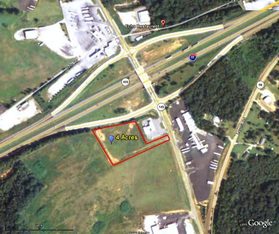
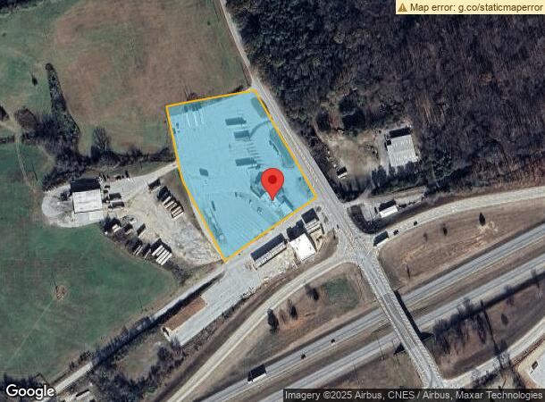
11379 Highway 106
Restaurantbuilding
3.5AC ECHO RESTAURANT
X
Franklin
13119C0113C
Georgia
2024
3.50 AC
2024
Georgia Northeast
890202
Other Market Areas
6,058 SF
035-018
DEMOGRAPHICS near 11379 Highway 106
1 Mile
3 Mile
5 Mile
2024 Total Population
142
2,108
4,504
2029 Population
152
2,254
4,807
Pop Growth 2024-2029
+ 7.04%
+ 6.93%
+ 6.73%
Average Age
40
41
41
2024 Total Households
53
779
1,677
HH Growth 2024-2029
+ 7.55%
+ 6.68%
+ 6.50%
Median Household Inc
$45,625
$50,977
$54,226
Avg Household Size
2.50
2.60
2.60
2024 Avg HH Vehicles
2.00
2.00
3.00
Median Home Value
$97,618
$116,832
$139,740
Median Year Built
1986
1989
1990
Nearby Places
- Restaurants
- Banks
- Shops
- Fitness
- Groceries
Nearby Properties
Address
Land Use
TOTAL SIZE
Lot Size
Zoning
Address
Land Use
TOTAL SIZE
Lot Size
Zoning
178.03 AC
UNZONED RU
Address
Land Use
TOTAL SIZE
Lot Size
Zoning
28,376 SF
30.69 AC
COMMERCIAL
Address
Land Use
TOTAL SIZE
Lot Size
Zoning
960 SF
11.46 AC
UNZONED RU
Address
Land Use
TOTAL SIZE
Lot Size
Zoning
15,152 SF
7.54 AC
COMMERCIAL
Address
Land Use
TOTAL SIZE
Lot Size
Zoning
7,200 SF
14.22 AC
COMMERCIAL
Address
Land Use
TOTAL SIZE
Lot Size
Zoning
5,632 SF
58.81 AC
COMMERCIAL
Address
Land Use
TOTAL SIZE
Lot Size
Zoning
10,000 SF
6.13 AC
RESIDENTIA
Address
Land Use
TOTAL SIZE
Lot Size
Zoning
1,064 SF
122.88 AC
UNZONED RU
Address
Land Use
TOTAL SIZE
Lot Size
Zoning
4,000 SF
5.94 AC
Address
Land Use
TOTAL SIZE
Lot Size
Zoning
248.05 AC
UNZONED RU
Address
Land Use
TOTAL SIZE
Lot Size
Zoning
20,211 SF
4.18 AC
COMMERCIAL
Address
Land Use
TOTAL SIZE
Lot Size
Zoning
44,311 SF
20 AC
RESIDENTIA
Address
Land Use
TOTAL SIZE
Lot Size
Zoning
12,760 SF
RESIDENTIA
Address
Land Use
TOTAL SIZE
Lot Size
Zoning
11,862 SF
5 AC
COMMERCIAL
Address
Land Use
TOTAL SIZE
Lot Size
Zoning
131.78 AC
UNZONED RU
Address
Land Use
TOTAL SIZE
Lot Size
Zoning
41.70 AC
UNZONED RU
Address
Land Use
TOTAL SIZE
Lot Size
Zoning
6,624 SF
1.20 AC
RESIDENTIA
Address
Land Use
TOTAL SIZE
Lot Size
Zoning
11,327 SF
1.25 AC
COMMERCIAL
Address
Land Use
TOTAL SIZE
Lot Size
Zoning
188.54 AC
UNZONED RU
Address
Land Use
TOTAL SIZE
Lot Size
Zoning
6,530 SF
5.12 AC
UNZONED RU
Address
Land Use
TOTAL SIZE
Lot Size
Zoning
121.27 AC
UNZONED RU
Address
Land Use
TOTAL SIZE
Lot Size
Zoning
7,650 SF
0.35 AC
Address
Land Use
TOTAL SIZE
Lot Size
Zoning
6,781 SF
1.03 AC
RESIDENTIA
Address
Land Use
TOTAL SIZE
Lot Size
Zoning
2,226 SF
59.20 AC
UNZONED RU
Address
Land Use
TOTAL SIZE
Lot Size
Zoning
4,555 SF
5.63 AC
COMMERCIAL
Address
Land Use
TOTAL SIZE
Lot Size
Zoning
96.61 AC
UNZONED RU
Address
Land Use
TOTAL SIZE
Lot Size
Zoning
4,930 SF
2 AC
COMMERCIAL
Address
Land Use
TOTAL SIZE
Lot Size
Zoning
4,088 SF
29.62 AC
UNZONED RU
Address
Land Use
TOTAL SIZE
Lot Size
Zoning
2,584 SF
1.14 AC
UNZONED RU
The World's #1 Commercial Real Estate Marketplace
Connect with us
© 2025 CoStar Group
The information above has been obtained from sources believed reliable. While we do not doubt its accuracy we have not verified it and make no guarantee, warranty or representation about it. It is your responsibility to independently confirm its accuracy and completeness. Any projections, opinions, assumptions, or estimates used are for example only and do not represent the current or future performance of the property. The value of this transaction to you depends on tax and other factors which should be evaluated by your tax, financial, and legal advisors. You and your advisors should conduct a careful, independent investigation of the property to determine to your satisfaction the suitability of the property for your needs.