Property Record
11396 Us Highway 98 W, Miramar Beach, FL 32550

NEARBY LISTINGS FOR SALE OR LEASE
-
-
View all Miramar Beach listings for sale on LoopNet.com
Property Detail
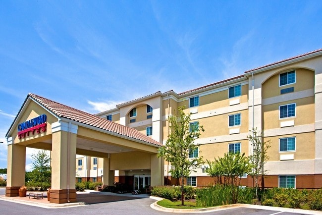
11396 Us Highway 98 W
28-2S-21-42000-023-0020
COM AT THE SW/C OF THE NW1/4 OF SEC 28; N 02 DEG 2649E ALONG THE W LINE OF NW4 OF SEC 269.05FT TO A POINT ON THE NLY ROW OF US HWY #98 & POB; CONT N 02 DEG 2649E ALONG W LINE 214.56 FT; DEPART W LINE, S 84 DEG 5130E 180.20FT; N 05 DEG 0430E 7.42 FT,
Hotel
Walton
X
Florida
12131C0538H
20
2025
1.84 AC
2025
Fort Walton Beach
950608
Other Market Areas
44,504 SF
Crestview-Fort Walton Beach-Destin, FL
DEMOGRAPHICS near 11396 Us Highway 98 W
1 Mile
3 Mile
5 Mile
2024 Total Population
4,492
17,839
28,433
2029 Population
5,990
22,911
35,618
Pop Growth 2024-2029
+ 33.35%
+ 28.43%
+ 25.27%
Average Age
53
51
48
2024 Total Households
2,234
8,651
13,052
HH Growth 2024-2029
+ 34.38%
+ 29.63%
+ 26.29%
Median Household Inc
$69,970
$78,022
$86,033
Avg Household Size
2.00
2.10
2.10
2024 Avg HH Vehicles
2.00
2.00
2.00
Median Home Value
$462,448
$487,377
$516,541
Median Year Built
1998
1999
2001
Nearby Places
Map Layers
Map Styles
 Street
 Aerial
- Restaurants
- Banks
- Shops
- Fitness
- Groceries
PUBLIC TRANSPORTATION
AIRPORT
Eglin AFB/Destin-Ft Walton Beach
DRIVE
WALK
Distance
Eglin AFB/Destin-Ft Walton Beach
51 min
21.6 mi
Freight Ports
Port of Panama City
DRIVE
WALK
Distance
Port of Panama City
65 min
42.8 mi
Nearby Properties
Address
Land Use
TOTAL SIZE
Lot Size
Zoning
Address
Land Use
TOTAL SIZE
Lot Size
Zoning
437,780 SF
9.40 AC
SD
Address
Land Use
TOTAL SIZE
Lot Size
Zoning
429,135 SF
23.38 AC
HWY 98
Address
Land Use
TOTAL SIZE
Lot Size
Zoning
267,405 SF
1.54 AC
Address
Land Use
TOTAL SIZE
Lot Size
Zoning
269,575 SF
5.60 AC
SD
Address
Land Use
TOTAL SIZE
Lot Size
Zoning
135,360 SF
16 AC
Address
Land Use
TOTAL SIZE
Lot Size
Zoning
5.19 AC
GULFFR
Address
Land Use
TOTAL SIZE
Lot Size
Zoning
218,504 SF
11.87 AC
HWY 98
Address
Land Use
TOTAL SIZE
Lot Size
Zoning
195,860 SF
14.03 AC
HWY 98
Address
Land Use
TOTAL SIZE
Lot Size
Zoning
182,539 SF
2.60 AC
SD
Address
Land Use
TOTAL SIZE
Lot Size
Zoning
19,401 SF
6.66 AC
Address
Land Use
TOTAL SIZE
Lot Size
Zoning
138,905 SF
4.01 AC
Address
Land Use
TOTAL SIZE
Lot Size
Zoning
115,433 SF
0.96 AC
Address
Land Use
TOTAL SIZE
Lot Size
Zoning
118,963 SF
7.58 AC
Address
Land Use
TOTAL SIZE
Lot Size
Zoning
74,662 SF
6.02 AC
HWY 98
Address
Land Use
TOTAL SIZE
Lot Size
Zoning
135,599 SF
1.21 AC
HWY 98
Address
Land Use
TOTAL SIZE
Lot Size
Zoning
9,534 SF
12.45 AC
BAYS
Address
Land Use
TOTAL SIZE
Lot Size
Zoning
65,340 SF
1.01 AC
CCMU
Address
Land Use
TOTAL SIZE
Lot Size
Zoning
87,959 SF
2.76 AC
HWY 98
Address
Land Use
TOTAL SIZE
Lot Size
Zoning
66,001 SF
1.25 AC
HWY 98
Address
Land Use
TOTAL SIZE
Lot Size
Zoning
1,500 SF
241.13 AC
Address
Land Use
TOTAL SIZE
Lot Size
Zoning
18,731 SF
10.15 AC
GULFFR
Address
Land Use
TOTAL SIZE
Lot Size
Zoning
1.81 AC
GULFFR
Address
Land Use
TOTAL SIZE
Lot Size
Zoning
67,668 SF
1.56 AC
Address
Land Use
TOTAL SIZE
Lot Size
Zoning
123,120 SF
4.11 AC
HWY 98
Address
Land Use
TOTAL SIZE
Lot Size
Zoning
7,416 SF
25.45 AC
HWY 98
Address
Land Use
TOTAL SIZE
Lot Size
Zoning
68,849 SF
6.75 AC
HWY 98
Address
Land Use
TOTAL SIZE
Lot Size
Zoning
50,665 SF
5.47 AC
Address
Land Use
TOTAL SIZE
Lot Size
Zoning
89,369 SF
6.54 AC
HWY 98
Address
Land Use
TOTAL SIZE
Lot Size
Zoning
69,744 SF
4.12 AC
Address
Land Use
TOTAL SIZE
Lot Size
Zoning
119,173 SF
245.14 AC
BAYS
The World's #1 Commercial Real Estate Marketplace
Connect with us
© 2026 CoStar Group
The information above has been obtained from sources believed reliable. While we do not doubt its accuracy we have not verified it and make no guarantee, warranty or representation about it. It is your responsibility to independently confirm its accuracy and completeness. Any projections, opinions, assumptions, or estimates used are for example only and do not represent the current or future performance of the property. The value of this transaction to you depends on tax and other factors which should be evaluated by your tax, financial, and legal advisors. You and your advisors should conduct a careful, independent investigation of the property to determine to your satisfaction the suitability of the property for your needs.