Property Record
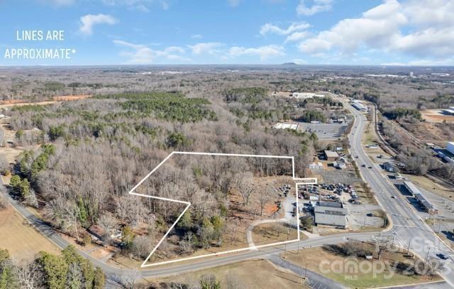
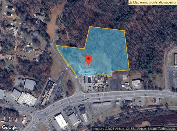
114 Costner School Rd, Bessemer City, NC 28016
This Property Is For Sale
NEARBY LISTINGS FOR SALE OR LEASE
Property Detail
114 Costner School Rd
120509
J A Parker Lands
Commercialnec
02 006 057 00 000
X
Gaston
3710352600J
North Carolina
2024
6.63 AC
2024
Gaston County
030802
Charlotte
984 SF
Charlotte-Concord-Gastonia, NC-SC
DEMOGRAPHICS near 114 Costner School Rd
1 Mile
3 Mile
5 Mile
2024 Total Population
3,105
13,546
48,744
2029 Population
3,312
14,522
52,193
Pop Growth 2024-2029
+ 6.67%
+ 7.21%
+ 7.08%
Average Age
41
40
39
2024 Total Households
1,290
5,335
18,984
HH Growth 2024-2029
+ 6.74%
+ 7.35%
+ 7.24%
Median Household Inc
$35,559
$39,606
$42,471
Avg Household Size
2.40
2.50
2.50
2024 Avg HH Vehicles
2.00
2.00
2.00
Median Home Value
$169,366
$154,257
$158,594
Median Year Built
1974
1974
1972
Nearby Places
- Restaurants
- Banks
- Shops
- Fitness
- Groceries
PUBLIC TRANSPORTATION
COMMUTER RAIL
Gastonia Amtrak Station (Crescent - Amtrak)
DRIVE
WALK
Distance
Gastonia Amtrak Station (Crescent - Amtrak)
12 min
7.9 mi
AIRPORT
Charlotte/Douglas International
DRIVE
WALK
Distance
Charlotte/Douglas International
37 min
22.7 mi
Freight Ports
North Charleston Terminal
DRIVE
WALK
Distance
North Charleston Terminal
251 min
218.7 mi
Nearby Properties
Address
Land Use
TOTAL SIZE
Lot Size
Zoning
Address
Land Use
TOTAL SIZE
Lot Size
Zoning
68.71 AC
Address
Land Use
TOTAL SIZE
Lot Size
Zoning
268,563 SF
116.96 AC
MANU1
Address
Land Use
TOTAL SIZE
Lot Size
Zoning
Address
Land Use
TOTAL SIZE
Lot Size
Zoning
1,200 SF
487.79 AC
I2
Address
Land Use
TOTAL SIZE
Lot Size
Zoning
2,250 SF
27.79 AC
OFF01
Address
Land Use
TOTAL SIZE
Lot Size
Zoning
539,988 SF
36.32 AC
STOR6
Address
Land Use
TOTAL SIZE
Lot Size
Zoning
192,978 SF
22.67 AC
RET05
Address
Land Use
TOTAL SIZE
Lot Size
Zoning
167,332 SF
19.92 AC
INDS1
Address
Land Use
TOTAL SIZE
Lot Size
Zoning
Address
Land Use
TOTAL SIZE
Lot Size
Zoning
105,285 SF
25.27 AC
INDS1
Address
Land Use
TOTAL SIZE
Lot Size
Zoning
514,404 SF
27.84 AC
INDS2
Address
Land Use
TOTAL SIZE
Lot Size
Zoning
780 SF
7.07 AC
APT01
Address
Land Use
TOTAL SIZE
Lot Size
Zoning
16,628 SF
27.04 AC
PUB01
Address
Land Use
TOTAL SIZE
Lot Size
Zoning
29,132 SF
34.77 AC
PUB01
Address
Land Use
TOTAL SIZE
Lot Size
Zoning
60,685 SF
21.19 AC
PUB01
Address
Land Use
TOTAL SIZE
Lot Size
Zoning
110,840 SF
13.12 AC
INDS1
Address
Land Use
TOTAL SIZE
Lot Size
Zoning
163,106 SF
11.19 AC
STOR2
Address
Land Use
TOTAL SIZE
Lot Size
Zoning
60,916 SF
42.13 AC
Address
Land Use
TOTAL SIZE
Lot Size
Zoning
9,968 SF
18.38 AC
PUB01
Address
Land Use
TOTAL SIZE
Lot Size
Zoning
17.37 AC
Address
Land Use
TOTAL SIZE
Lot Size
Zoning
81,000 SF
10.31 AC
INDS2
Address
Land Use
TOTAL SIZE
Lot Size
Zoning
902 SF
8.23 AC
APT01
Address
Land Use
TOTAL SIZE
Lot Size
Zoning
139,947 SF
22.96 AC
INDS1
Address
Land Use
TOTAL SIZE
Lot Size
Zoning
7,184 SF
4.73 AC
MOTL2
Address
Land Use
TOTAL SIZE
Lot Size
Zoning
408,172 SF
12.84 AC
INDS1
Address
Land Use
TOTAL SIZE
Lot Size
Zoning
20,000 SF
23.07 AC
INDS1
Address
Land Use
TOTAL SIZE
Lot Size
Zoning
1,440 SF
12.82 AC
Address
Land Use
TOTAL SIZE
Lot Size
Zoning
128,778 SF
8.79 AC
INDS2
Address
Land Use
TOTAL SIZE
Lot Size
Zoning
23,048 SF
3.57 AC
CHUR1
Address
Land Use
TOTAL SIZE
Lot Size
Zoning
157,421 SF
10.73 AC
INDS1
The World's #1 Commercial Real Estate Marketplace
Connect with us
© 2025 CoStar Group
The information above has been obtained from sources believed reliable. While we do not doubt its accuracy we have not verified it and make no guarantee, warranty or representation about it. It is your responsibility to independently confirm its accuracy and completeness. Any projections, opinions, assumptions, or estimates used are for example only and do not represent the current or future performance of the property. The value of this transaction to you depends on tax and other factors which should be evaluated by your tax, financial, and legal advisors. You and your advisors should conduct a careful, independent investigation of the property to determine to your satisfaction the suitability of the property for your needs.