Property Record
11427 N Highway 59, Gravette, AR 72736
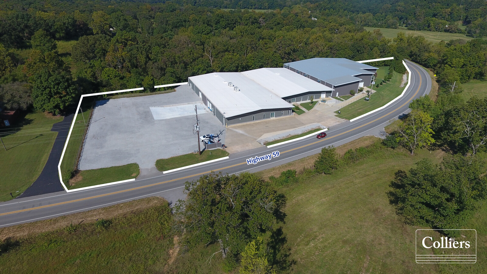
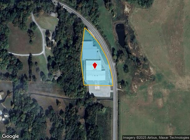
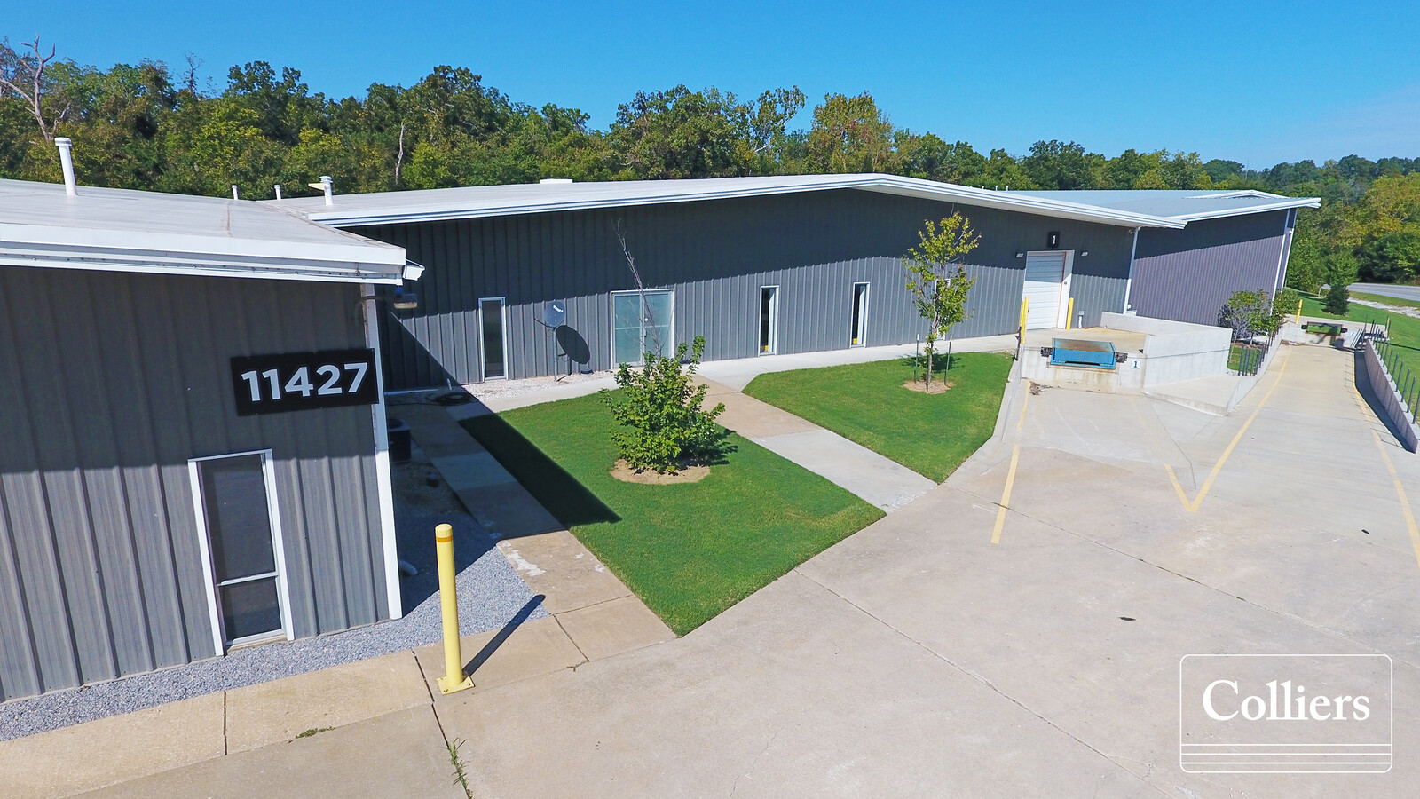
This Property Is For Sale
Current Lease Availabilities
NEARBY LISTINGS FOR SALE OR LEASE
Property Detail
11427 N Highway 59
18-15179-000
Rural
Warehouse
PART OF THE NW 1/4 OF THE SE 1/4 OF SECTION 24, TOWNSHIP 20 NORTH, RANGE 33 WEST, BENTON COUNTY, ARKANSAS, MORE PARTICULARLY DESCRIBED AS FOLLOWS: FROM THE SE CORNER OF SAID NW 1/4, SE 1/4, SECTION 24; RUN THENCE NORTH 88 1215 WEST 65.40 FEET TO THE
X
Benton
29119C0400D
Arkansas
2024
2.72 AC
2024
Outlying Benton County
021001
Fayetteville/Springdale/Rogers
57,116 SF
Fayetteville-Springdale-Rogers, AR-MO
DEMOGRAPHICS near 11427 N Highway 59
1 Mile
3 Mile
5 Mile
2024 Total Population
200
4,311
8,374
2029 Population
235
5,073
9,852
Pop Growth 2024-2029
+ 17.50%
+ 17.68%
+ 17.65%
Average Age
38
38
39
2024 Total Households
72
1,560
3,000
HH Growth 2024-2029
+ 18.06%
+ 17.69%
+ 17.67%
Median Household Inc
$54,000
$58,019
$62,082
Avg Household Size
2.70
2.70
2.80
2024 Avg HH Vehicles
2.00
2.00
2.00
Median Home Value
$169,565
$181,025
$195,153
Median Year Built
1992
1991
1991
Nearby Places
- Restaurants
- Banks
- Shops
- Fitness
- Groceries
PUBLIC TRANSPORTATION
AIRPORT
Northwest Arkansas Ntl
DRIVE
WALK
Distance
Northwest Arkansas Ntl
40 min
20.1 mi
Freight Ports
Tulsa Port of Inola
DRIVE
WALK
Distance
Tulsa Port of Inola
97 min
81.8 mi
Nearby Properties
Address
Land Use
TOTAL SIZE
Lot Size
Zoning
Address
Land Use
TOTAL SIZE
Lot Size
Zoning
58,602 SF
41.78 AC
Address
Land Use
TOTAL SIZE
Lot Size
Zoning
79,301 SF
15.96 AC
Address
Land Use
TOTAL SIZE
Lot Size
Zoning
4,903 SF
0.97 AC
Address
Land Use
TOTAL SIZE
Lot Size
Zoning
14,521 SF
111.82 AC
Address
Land Use
TOTAL SIZE
Lot Size
Zoning
66,890 SF
9.67 AC
Address
Land Use
TOTAL SIZE
Lot Size
Zoning
27,229 SF
2.25 AC
Address
Land Use
TOTAL SIZE
Lot Size
Zoning
40,024 SF
9 AC
Address
Land Use
TOTAL SIZE
Lot Size
Zoning
8,200 SF
0.81 AC
Address
Land Use
TOTAL SIZE
Lot Size
Zoning
20,270 SF
5.19 AC
Address
Land Use
TOTAL SIZE
Lot Size
Zoning
9,717 SF
0.41 AC
Address
Land Use
TOTAL SIZE
Lot Size
Zoning
6,088 SF
0.64 AC
Address
Land Use
TOTAL SIZE
Lot Size
Zoning
14,862 SF
2.06 AC
Address
Land Use
TOTAL SIZE
Lot Size
Zoning
65,955 SF
9.40 AC
Address
Land Use
TOTAL SIZE
Lot Size
Zoning
3,535 SF
1.43 AC
Address
Land Use
TOTAL SIZE
Lot Size
Zoning
9,130 SF
0.24 AC
Address
Land Use
TOTAL SIZE
Lot Size
Zoning
17,752 SF
3.79 AC
Address
Land Use
TOTAL SIZE
Lot Size
Zoning
4,949 SF
2.79 AC
Address
Land Use
TOTAL SIZE
Lot Size
Zoning
34,500 SF
4.69 AC
Address
Land Use
TOTAL SIZE
Lot Size
Zoning
7,802 SF
1.60 AC
Address
Land Use
TOTAL SIZE
Lot Size
Zoning
2,520 SF
0.25 AC
Address
Land Use
TOTAL SIZE
Lot Size
Zoning
17,684 SF
3.01 AC
Address
Land Use
TOTAL SIZE
Lot Size
Zoning
33,176 SF
3.59 AC
Address
Land Use
TOTAL SIZE
Lot Size
Zoning
3,676 SF
0.21 AC
Address
Land Use
TOTAL SIZE
Lot Size
Zoning
2,076 SF
0.45 AC
Address
Land Use
TOTAL SIZE
Lot Size
Zoning
7,056 SF
1.21 AC
Address
Land Use
TOTAL SIZE
Lot Size
Zoning
15,028 SF
6.12 AC
Address
Land Use
TOTAL SIZE
Lot Size
Zoning
2,800 SF
0.34 AC
Address
Land Use
TOTAL SIZE
Lot Size
Zoning
6,300 SF
0.53 AC
Address
Land Use
TOTAL SIZE
Lot Size
Zoning
14,992 SF
1.24 AC
The World's #1 Commercial Real Estate Marketplace
Connect with us
© 2025 CoStar Group
The information above has been obtained from sources believed reliable. While we do not doubt its accuracy we have not verified it and make no guarantee, warranty or representation about it. It is your responsibility to independently confirm its accuracy and completeness. Any projections, opinions, assumptions, or estimates used are for example only and do not represent the current or future performance of the property. The value of this transaction to you depends on tax and other factors which should be evaluated by your tax, financial, and legal advisors. You and your advisors should conduct a careful, independent investigation of the property to determine to your satisfaction the suitability of the property for your needs.