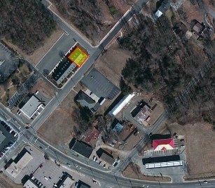
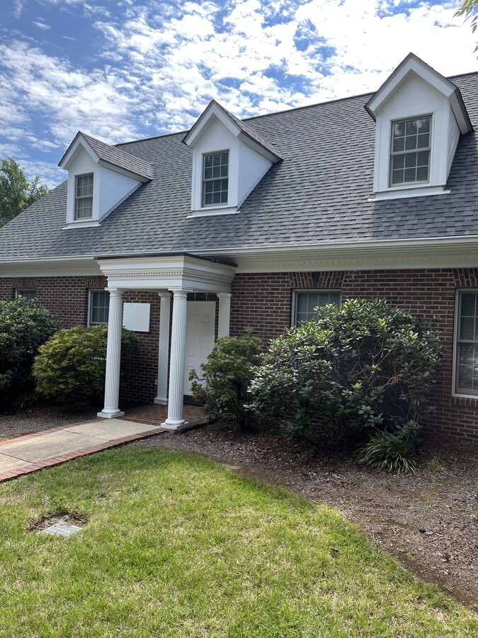
Property Record
115 Brown St, Salisbury, NC 28146
NEARBY LISTINGS FOR SALE OR LEASE
-
-
View all Salisbury listings for sale on LoopNet.com
Property Detail
115 Brown St
648-A059
F&M Business Park Condominiums Phase I
Officebuilding
UNIT 102
X
Rowan
3710567800J
North Carolina
2024
0.04 AC
2024
Rowan County
0517002044
Charlotte
2,592 SF
Charlotte-Concord-Gastonia, NC-SC
DEMOGRAPHICS near 115 Brown St
1 Mile
3 Mile
5 Mile
2024 Total Population
2,545
15,013
47,608
2029 Population
2,626
15,605
50,047
Pop Growth 2024-2029
+ 3.18%
+ 3.94%
+ 5.12%
Average Age
41
42
40
2024 Total Households
992
6,131
19,079
HH Growth 2024-2029
+ 3.13%
+ 3.98%
+ 5.19%
Median Household Inc
$67,949
$61,989
$52,621
Avg Household Size
2.60
2.40
2.40
2024 Avg HH Vehicles
2.00
2.00
2.00
Median Home Value
$217,671
$202,064
$190,468
Median Year Built
1986
1986
1978
Nearby Places
- Restaurants
- Banks
- Shops
- Fitness
- Groceries
PUBLIC TRANSPORTATION
COMMUTER RAIL
Salisbury Station (Piedmont - North Carolina by Train (NC Train))
DRIVE
WALK
Distance
Salisbury Station (Piedmont - North Carolina by Train (NC Train))
9 min
4.1 mi
AIRPORT
Concord-Padgett Regional
DRIVE
WALK
Distance
Concord-Padgett Regional
41 min
29.9 mi
Freight Ports
Port of Wilmington
DRIVE
WALK
Distance
Port of Wilmington
260 min
202.1 mi
SALE & LEASE HISTORY
LISTING DATE
SALE/LEASE

Nov 01, 2022
For Sale
Aug 05, 2017
For Sale
Apr 19, 2023
For Sale
Nearby Properties
Address
Land Use
TOTAL SIZE
Lot Size
Zoning
Address
Land Use
TOTAL SIZE
Lot Size
Zoning
116,333 SF
30.31 AC
Address
Land Use
TOTAL SIZE
Lot Size
Zoning
668,345 SF
104.91 AC
Address
Land Use
TOTAL SIZE
Lot Size
Zoning
41,142 SF
16.18 AC
Address
Land Use
TOTAL SIZE
Lot Size
Zoning
48,865 SF
55.30 AC
HB:HIGHWAY
Address
Land Use
TOTAL SIZE
Lot Size
Zoning
338,336 SF
32.55 AC
Address
Land Use
TOTAL SIZE
Lot Size
Zoning
144,720 SF
14.53 AC
Address
Land Use
TOTAL SIZE
Lot Size
Zoning
37,281 SF
10 AC
Address
Land Use
TOTAL SIZE
Lot Size
Zoning
81,480 SF
42.85 AC
Address
Land Use
TOTAL SIZE
Lot Size
Zoning
56,676 SF
2.73 AC
HB:HIGHWAY
Address
Land Use
TOTAL SIZE
Lot Size
Zoning
69,072 SF
11.32 AC
HB:HIGHWAY
Address
Land Use
TOTAL SIZE
Lot Size
Zoning
69,433 SF
21.31 AC
Address
Land Use
TOTAL SIZE
Lot Size
Zoning
111,118 SF
24.07 AC
Address
Land Use
TOTAL SIZE
Lot Size
Zoning
54,879 SF
1.74 AC
Address
Land Use
TOTAL SIZE
Lot Size
Zoning
154,502 SF
35.91 AC
Address
Land Use
TOTAL SIZE
Lot Size
Zoning
84,336 SF
34.98 AC
RR
Address
Land Use
TOTAL SIZE
Lot Size
Zoning
23,526 SF
9.36 AC
Address
Land Use
TOTAL SIZE
Lot Size
Zoning
95,916 SF
24.60 AC
M1:LIGHT I
Address
Land Use
TOTAL SIZE
Lot Size
Zoning
70,424 SF
7.18 AC
Address
Land Use
TOTAL SIZE
Lot Size
Zoning
226,872 SF
24.61 AC
I1:LIGHT I
Address
Land Use
TOTAL SIZE
Lot Size
Zoning
24,768 SF
16.77 AC
Address
Land Use
TOTAL SIZE
Lot Size
Zoning
51,920 SF
39.63 AC
Address
Land Use
TOTAL SIZE
Lot Size
Zoning
126,672 SF
49.69 AC
Address
Land Use
TOTAL SIZE
Lot Size
Zoning
57,252 SF
20.95 AC
Address
Land Use
TOTAL SIZE
Lot Size
Zoning
98,024 SF
8.40 AC
Address
Land Use
TOTAL SIZE
Lot Size
Zoning
114,794 SF
Address
Land Use
TOTAL SIZE
Lot Size
Zoning
19,096 SF
9.18 AC
HB:HIGHWAY
Address
Land Use
TOTAL SIZE
Lot Size
Zoning
5,000 SF
57.22 AC
Address
Land Use
TOTAL SIZE
Lot Size
Zoning
99,954 SF
14 AC
Address
Land Use
TOTAL SIZE
Lot Size
Zoning
22,360 SF
12.48 AC
Address
Land Use
TOTAL SIZE
Lot Size
Zoning
55,220 SF
2.94 AC
The World's #1 Commercial Real Estate Marketplace
Connect with us
© 2025 CoStar Group
The information above has been obtained from sources believed reliable. While we do not doubt its accuracy we have not verified it and make no guarantee, warranty or representation about it. It is your responsibility to independently confirm its accuracy and completeness. Any projections, opinions, assumptions, or estimates used are for example only and do not represent the current or future performance of the property. The value of this transaction to you depends on tax and other factors which should be evaluated by your tax, financial, and legal advisors. You and your advisors should conduct a careful, independent investigation of the property to determine to your satisfaction the suitability of the property for your needs.