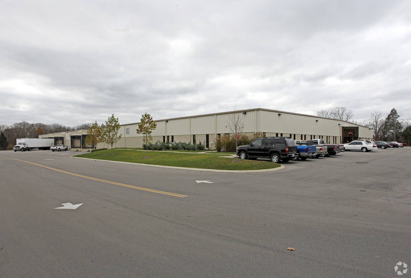
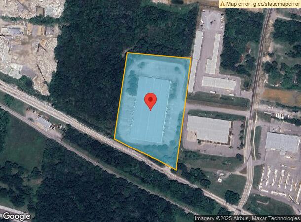
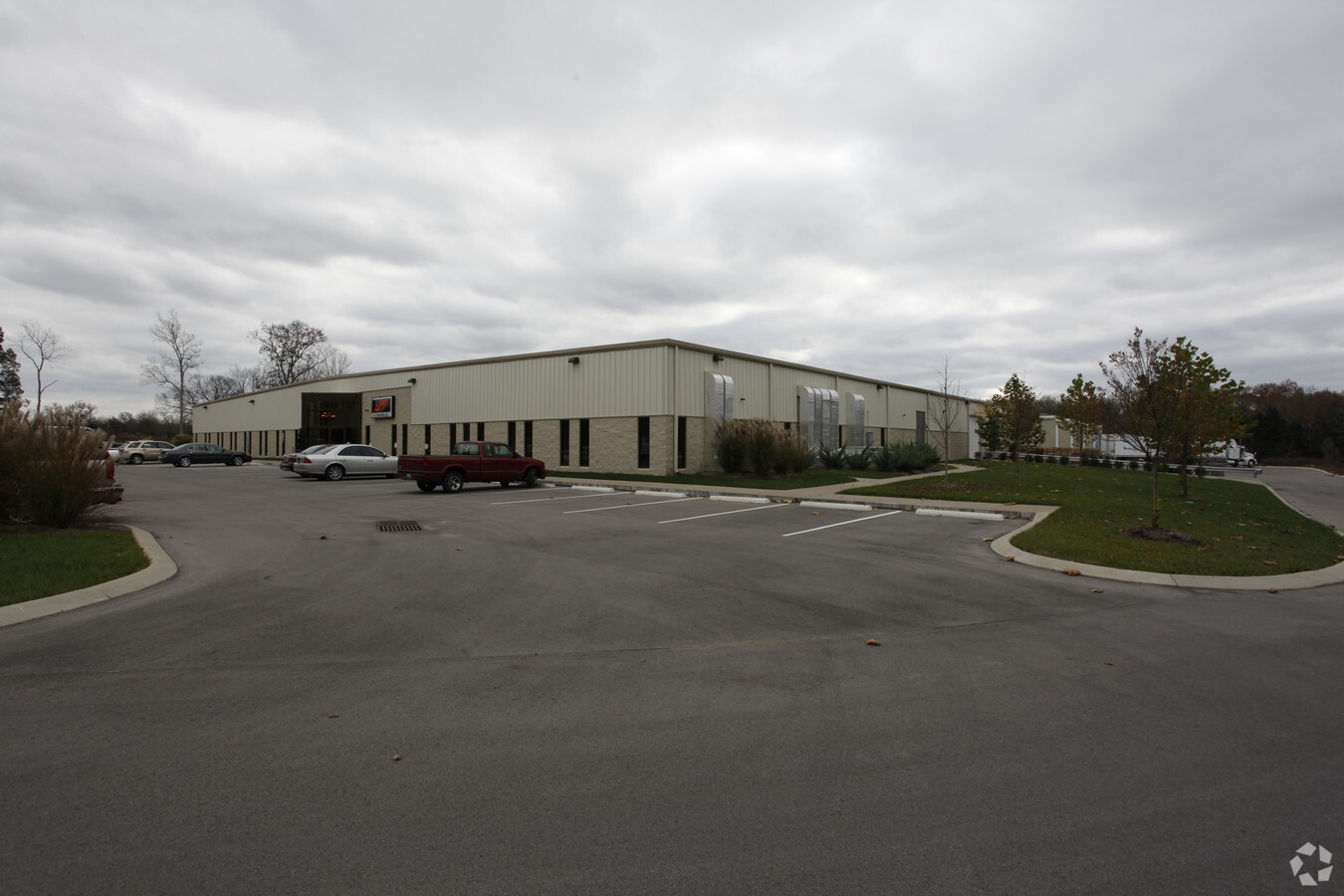
Property Record
115 Clemmons Rd, Mount Juliet, TN 37122
NEARBY LISTINGS FOR SALE OR LEASE
Property Detail
115 Clemmons Rd
Nashville-Davidson--Murfreesboro--Franklin, TN
Ken Stilts Investments
072-064.00
KEN STILTS INVESTMENTS PB 27 PG 85 LOT 1 REMAR INC.
Municipalproperty
Wilson
X
Tennessee
47189C0134E
1
2023
5.84 AC
2024
Wilson County
030309
Nashville
80,823 SF
DEMOGRAPHICS near 115 Clemmons Rd
1 Mile
3 Mile
5 Mile
2024 Total Population
2,802
34,995
75,860
2029 Population
3,315
41,324
86,912
Pop Growth 2024-2029
+ 18.31%
+ 18.09%
+ 14.57%
Average Age
40
38
39
2024 Total Households
1,039
12,930
28,187
HH Growth 2024-2029
+ 18.38%
+ 17.90%
+ 14.09%
Median Household Inc
$83,450
$99,183
$97,500
Avg Household Size
2.60
2.70
2.60
2024 Avg HH Vehicles
2.00
2.00
2.00
Median Home Value
$358,484
$391,084
$367,100
Median Year Built
2003
2005
2001
Nearby Places
- Restaurants
- Banks
- Shops
- Fitness
- Groceries
PUBLIC TRANSPORTATION
COMMUTER RAIL
Mt Juliet (East Corridor Line - Tennessee Regional Transportation Authority Music City Star (Music City Star))
DRIVE
WALK
Distance
Mt Juliet (East Corridor Line - Tennessee Regional Transportation Authority Music City Star (Music City Star))
3 min
18 min
0.9 mi
Martha (East Corridor Line - Tennessee Regional Transportation Authority Music City Star (Music City Star))
DRIVE
WALK
Distance
Martha (East Corridor Line - Tennessee Regional Transportation Authority Music City Star (Music City Star))
15 min
8.3 mi
AIRPORT
Nashville International
DRIVE
WALK
Distance
Nashville International
21 min
14.6 mi
Freight Ports
Port of Mobile
DRIVE
WALK
Distance
Port of Mobile
505 min
461.4 mi
Nearby Properties
Address
Land Use
TOTAL SIZE
Lot Size
Zoning
Address
Land Use
TOTAL SIZE
Lot Size
Zoning
1,493,463 SF
54.91 AC
Address
Land Use
TOTAL SIZE
Lot Size
Zoning
692,210 SF
52.09 AC
C4
Address
Land Use
TOTAL SIZE
Lot Size
Zoning
548,645 SF
28 AC
CI
Address
Land Use
TOTAL SIZE
Lot Size
Zoning
384,263 SF
27.59 AC
Address
Land Use
TOTAL SIZE
Lot Size
Zoning
1,089,622 SF
54.87 AC
Address
Land Use
TOTAL SIZE
Lot Size
Zoning
611,467 SF
88.97 AC
Address
Land Use
TOTAL SIZE
Lot Size
Zoning
296,500 SF
4.42 AC
Address
Land Use
TOTAL SIZE
Lot Size
Zoning
105,709 SF
11.38 AC
Address
Land Use
TOTAL SIZE
Lot Size
Zoning
197,114 SF
7.01 AC
Address
Land Use
TOTAL SIZE
Lot Size
Zoning
258,534 SF
14.15 AC
Address
Land Use
TOTAL SIZE
Lot Size
Zoning
308,062 SF
20.55 AC
RM16
Address
Land Use
TOTAL SIZE
Lot Size
Zoning
337,419 SF
22.77 AC
Address
Land Use
TOTAL SIZE
Lot Size
Zoning
528,580 SF
25 AC
Address
Land Use
TOTAL SIZE
Lot Size
Zoning
704,800 SF
48.96 AC
Address
Land Use
TOTAL SIZE
Lot Size
Zoning
232,014 SF
17.89 AC
RM16
Address
Land Use
TOTAL SIZE
Lot Size
Zoning
459,108 SF
41.82 AC
Address
Land Use
TOTAL SIZE
Lot Size
Zoning
501,866 SF
52.09 AC
C4
Address
Land Use
TOTAL SIZE
Lot Size
Zoning
183,224 SF
23.62 AC
CMU
Address
Land Use
TOTAL SIZE
Lot Size
Zoning
104,601 SF
2.42 AC
C1
Address
Land Use
TOTAL SIZE
Lot Size
Zoning
479,936 SF
27.70 AC
IR
Address
Land Use
TOTAL SIZE
Lot Size
Zoning
308,249 SF
203 AC
Address
Land Use
TOTAL SIZE
Lot Size
Zoning
86,013 SF
7 AC
Address
Land Use
TOTAL SIZE
Lot Size
Zoning
102,905 SF
21.42 AC
C1
Address
Land Use
TOTAL SIZE
Lot Size
Zoning
122,364 SF
16.73 AC
CMU
Address
Land Use
TOTAL SIZE
Lot Size
Zoning
104,810 SF
11.44 AC
Address
Land Use
TOTAL SIZE
Lot Size
Zoning
240,415 SF
16.52 AC
Address
Land Use
TOTAL SIZE
Lot Size
Zoning
248,088 SF
17.60 AC
Address
Land Use
TOTAL SIZE
Lot Size
Zoning
38,625 SF
8 AC
RS40
Address
Land Use
TOTAL SIZE
Lot Size
Zoning
74,436 SF
2.09 AC
Address
Land Use
TOTAL SIZE
Lot Size
Zoning
95,840 SF
9.68 AC
CMU
The World's #1 Commercial Real Estate Marketplace
Connect with us
© 2025 CoStar Group
The information above has been obtained from sources believed reliable. While we do not doubt its accuracy we have not verified it and make no guarantee, warranty or representation about it. It is your responsibility to independently confirm its accuracy and completeness. Any projections, opinions, assumptions, or estimates used are for example only and do not represent the current or future performance of the property. The value of this transaction to you depends on tax and other factors which should be evaluated by your tax, financial, and legal advisors. You and your advisors should conduct a careful, independent investigation of the property to determine to your satisfaction the suitability of the property for your needs.