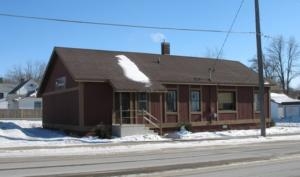
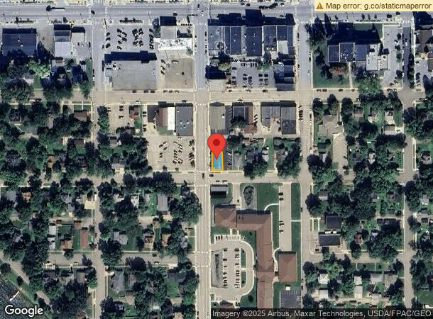
Property Record
115 Franklin St S, Glenwood, MN 56334
NEARBY LISTINGS FOR SALE OR LEASE
-
-
View all Glenwood listings for sale on LoopNet.com
Property Detail
115 Franklin St S
Minnesota Central Area
Glenwood City, Original Plat
Other Market Areas
W 39 FT OF S 70 FT OF LOT 6 BLOCK 26
21-0237-000
Pope
Commercialnec
Minnesota
2024
6
2024
0.06 AC
970400
DEMOGRAPHICS near 115 Franklin St S
1 Mile
3 Mile
5 Mile
2024 Total Population
2,585
3,727
4,867
2029 Population
2,673
3,867
5,061
Pop Growth 2024-2029
+ 3.40%
+ 3.76%
+ 3.99%
Average Age
44
45
45
2024 Total Households
1,182
1,704
2,196
HH Growth 2024-2029
+ 3.64%
+ 3.93%
+ 4.10%
Median Household Inc
$58,105
$61,377
$65,230
Avg Household Size
2.10
2.10
2.20
2024 Avg HH Vehicles
2.00
2.00
2.00
Median Home Value
$182,404
$204,762
$235,227
Median Year Built
1973
1974
1975
Nearby Places
- Restaurants
- Banks
- Shops
- Fitness
- Groceries
Nearby Properties
Address
Land Use
TOTAL SIZE
Lot Size
Zoning
Address
Land Use
TOTAL SIZE
Lot Size
Zoning
5.25 AC
Address
Land Use
TOTAL SIZE
Lot Size
Zoning
14,307 SF
1.88 AC
Address
Land Use
TOTAL SIZE
Lot Size
Zoning
60,990 SF
3.22 AC
Address
Land Use
TOTAL SIZE
Lot Size
Zoning
Address
Land Use
TOTAL SIZE
Lot Size
Zoning
3.89 AC
Address
Land Use
TOTAL SIZE
Lot Size
Zoning
2.27 AC
Address
Land Use
TOTAL SIZE
Lot Size
Zoning
12.03 AC
Address
Land Use
TOTAL SIZE
Lot Size
Zoning
19.35 AC
Address
Land Use
TOTAL SIZE
Lot Size
Zoning
7,238 SF
2.91 AC
Address
Land Use
TOTAL SIZE
Lot Size
Zoning
2,380 SF
1.78 AC
Address
Land Use
TOTAL SIZE
Lot Size
Zoning
Address
Land Use
TOTAL SIZE
Lot Size
Zoning
Address
Land Use
TOTAL SIZE
Lot Size
Zoning
Address
Land Use
TOTAL SIZE
Lot Size
Zoning
13.30 AC
Address
Land Use
TOTAL SIZE
Lot Size
Zoning
2,014 SF
0.62 AC
Address
Land Use
TOTAL SIZE
Lot Size
Zoning
0.53 AC
Address
Land Use
TOTAL SIZE
Lot Size
Zoning
Address
Land Use
TOTAL SIZE
Lot Size
Zoning
Address
Land Use
TOTAL SIZE
Lot Size
Zoning
11,004 SF
0.68 AC
Address
Land Use
TOTAL SIZE
Lot Size
Zoning
3.91 AC
Address
Land Use
TOTAL SIZE
Lot Size
Zoning
6.96 AC
Address
Land Use
TOTAL SIZE
Lot Size
Zoning
Address
Land Use
TOTAL SIZE
Lot Size
Zoning
5,143 SF
0.43 AC
Address
Land Use
TOTAL SIZE
Lot Size
Zoning
3.36 AC
Address
Land Use
TOTAL SIZE
Lot Size
Zoning
4.52 AC
Address
Land Use
TOTAL SIZE
Lot Size
Zoning
320 AC
Address
Land Use
TOTAL SIZE
Lot Size
Zoning
0.89 AC
Address
Land Use
TOTAL SIZE
Lot Size
Zoning
5,060 SF
0.12 AC
Address
Land Use
TOTAL SIZE
Lot Size
Zoning
The World's #1 Commercial Real Estate Marketplace
Connect with us
© 2025 CoStar Group
The information above has been obtained from sources believed reliable. While we do not doubt its accuracy we have not verified it and make no guarantee, warranty or representation about it. It is your responsibility to independently confirm its accuracy and completeness. Any projections, opinions, assumptions, or estimates used are for example only and do not represent the current or future performance of the property. The value of this transaction to you depends on tax and other factors which should be evaluated by your tax, financial, and legal advisors. You and your advisors should conduct a careful, independent investigation of the property to determine to your satisfaction the suitability of the property for your needs.