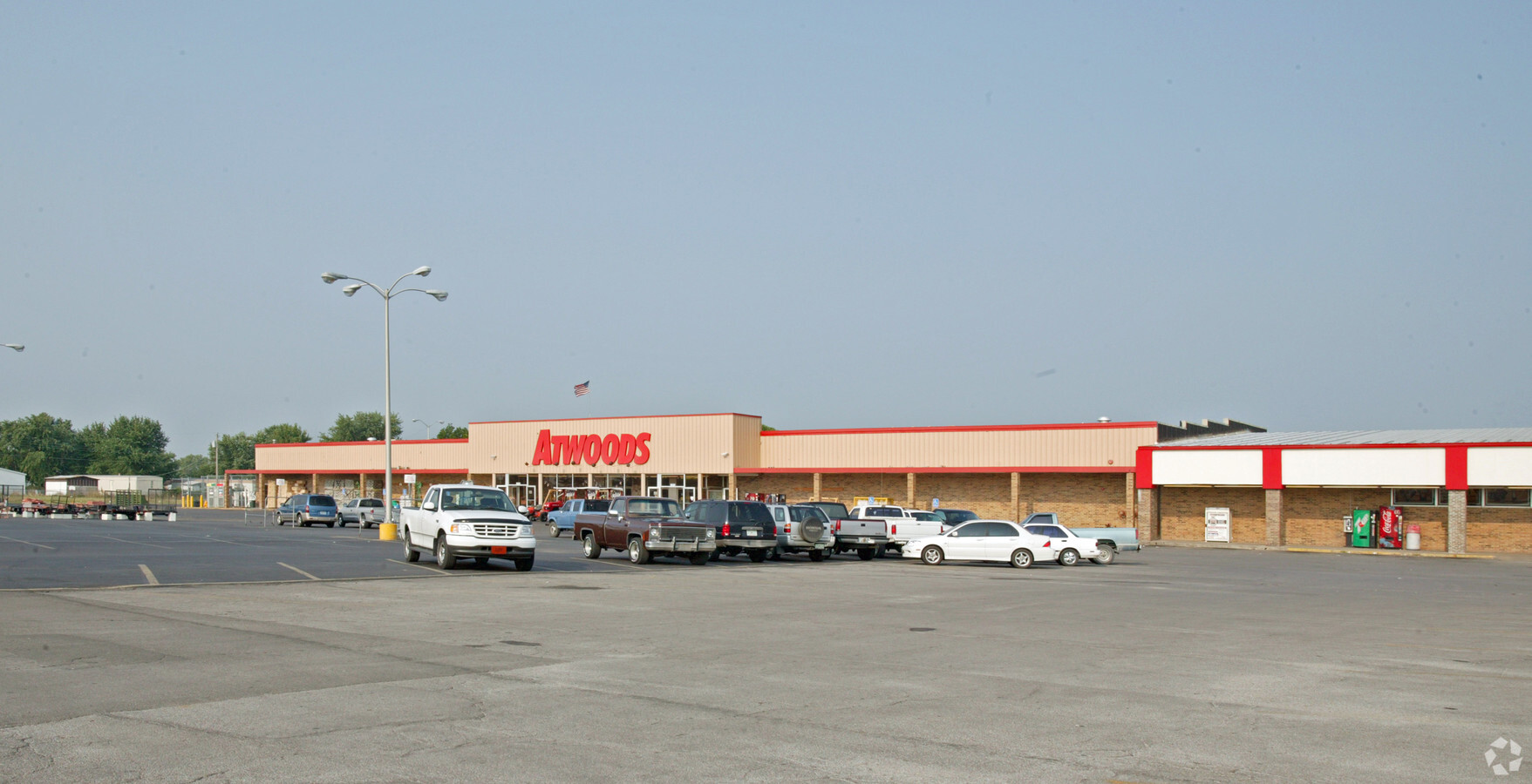
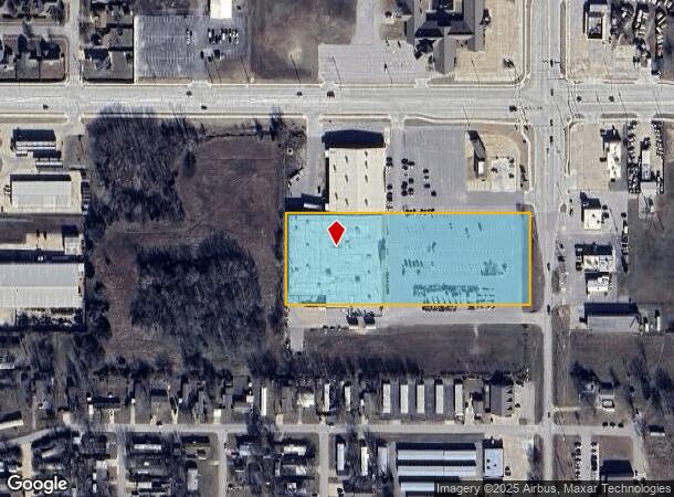
Property Record
11510 N Garnett Rd, Owasso, OK 74055

NEARBY LISTINGS FOR SALE OR LEASE
Property Detail
11510 N Garnett Rd
Tulsa, OK
Shopping Center At Hwys 169 And 20
57325-14-07-01785
S260 W282 & N260 S275 E413 LT 1 BLK 1
Departmentstore
Tulsa
X
Oklahoma
40131C0250H
1
2023
4.15 AC
2024
Northeast Tulsa
005811
Tulsa
65,830 SF
DEMOGRAPHICS near 11510 N Garnett Rd
1 Mile
3 Mile
5 Mile
2024 Total Population
5,480
32,179
66,308
2029 Population
5,655
33,464
69,413
Pop Growth 2024-2029
+ 3.19%
+ 3.99%
+ 4.68%
Average Age
35
37
38
2024 Total Households
1,962
11,824
24,537
HH Growth 2024-2029
+ 3.26%
+ 4.00%
+ 4.65%
Median Household Inc
$80,024
$79,858
$77,104
Avg Household Size
2.80
2.70
2.70
2024 Avg HH Vehicles
2.00
2.00
2.00
Median Home Value
$165,851
$210,909
$218,163
Median Year Built
2001
2001
1999
Nearby Places
- Restaurants
- Banks
- Shops
- Fitness
- Groceries
PUBLIC TRANSPORTATION
AIRPORT
Tulsa International
DRIVE
WALK
Distance
Tulsa International
19 min
11.5 mi
Freight Ports
Tulsa Port Of Catoosa
DRIVE
WALK
Distance
Tulsa Port Of Catoosa
22 min
14.3 mi
Nearby Properties
Address
Land Use
TOTAL SIZE
Lot Size
Zoning
Address
Land Use
TOTAL SIZE
Lot Size
Zoning
299,471 SF
64.32 AC
AG
Address
Land Use
TOTAL SIZE
Lot Size
Zoning
111,792 SF
12.43 AC
OM
Address
Land Use
TOTAL SIZE
Lot Size
Zoning
209,620 SF
19.59 AC
IM
Address
Land Use
TOTAL SIZE
Lot Size
Zoning
47,798 SF
5.13 AC
CS
Address
Land Use
TOTAL SIZE
Lot Size
Zoning
92,668 SF
19.30 AC
RS3
Address
Land Use
TOTAL SIZE
Lot Size
Zoning
138,427 SF
8.90 AC
OM
Address
Land Use
TOTAL SIZE
Lot Size
Zoning
105,098 SF
18.22 AC
RS2
Address
Land Use
TOTAL SIZE
Lot Size
Zoning
43,882 SF
10 AC
AG
Address
Land Use
TOTAL SIZE
Lot Size
Zoning
270,386 SF
14.65 AC
RM
Address
Land Use
TOTAL SIZE
Lot Size
Zoning
24,164 SF
11.81 AC
NCU
Address
Land Use
TOTAL SIZE
Lot Size
Zoning
31,502 SF
11.08 AC
AG
Address
Land Use
TOTAL SIZE
Lot Size
Zoning
17,600 SF
15.04 AC
RE
Address
Land Use
TOTAL SIZE
Lot Size
Zoning
266,778 SF
12.26 AC
CN
Address
Land Use
TOTAL SIZE
Lot Size
Zoning
226,062 SF
11.78 AC
RM2
Address
Land Use
TOTAL SIZE
Lot Size
Zoning
101,776 SF
9.96 AC
CS
Address
Land Use
TOTAL SIZE
Lot Size
Zoning
71,898 SF
3.66 AC
CS
Address
Land Use
TOTAL SIZE
Lot Size
Zoning
40,206 SF
3.72 AC
RS3
Address
Land Use
TOTAL SIZE
Lot Size
Zoning
40,822 SF
11.39 AC
AG
Address
Land Use
TOTAL SIZE
Lot Size
Zoning
28,400 SF
12.66 AC
AG
Address
Land Use
TOTAL SIZE
Lot Size
Zoning
178,815 SF
18.21 AC
CS
Address
Land Use
TOTAL SIZE
Lot Size
Zoning
133,301 SF
21.09 AC
RS3
Address
Land Use
TOTAL SIZE
Lot Size
Zoning
24,435 SF
4.41 AC
RE
Address
Land Use
TOTAL SIZE
Lot Size
Zoning
450 SF
10.35 AC
RS3
Address
Land Use
TOTAL SIZE
Lot Size
Zoning
208,326 SF
16.36 AC
CS
Address
Land Use
TOTAL SIZE
Lot Size
Zoning
16,388 SF
1.46 AC
CG
Address
Land Use
TOTAL SIZE
Lot Size
Zoning
31,781 SF
4.60 AC
AG
Address
Land Use
TOTAL SIZE
Lot Size
Zoning
3,679 SF
33.74 AC
AG
Address
Land Use
TOTAL SIZE
Lot Size
Zoning
33,157 SF
3.82 AC
AGR
Address
Land Use
TOTAL SIZE
Lot Size
Zoning
140,358 SF
5.10 AC
RM1
Address
Land Use
TOTAL SIZE
Lot Size
Zoning
61,622 SF
13.96 AC
CG
The World's #1 Commercial Real Estate Marketplace
Connect with us
© 2025 CoStar Group
The information above has been obtained from sources believed reliable. While we do not doubt its accuracy we have not verified it and make no guarantee, warranty or representation about it. It is your responsibility to independently confirm its accuracy and completeness. Any projections, opinions, assumptions, or estimates used are for example only and do not represent the current or future performance of the property. The value of this transaction to you depends on tax and other factors which should be evaluated by your tax, financial, and legal advisors. You and your advisors should conduct a careful, independent investigation of the property to determine to your satisfaction the suitability of the property for your needs.