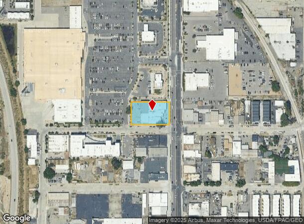
Property Record
1154 S 300 W, Salt Lake City, UT 84101

NEARBY LISTINGS FOR SALE OR LEASE
Property Detail
1154 S 300 W
Salt Lake City, UT
Davis Sharp & Stringers Sub
15-12-451-002-0000
LOTS 1 THRU 9, BLK 5 DAVIS SHARP & STRINGERS SUB TOGETHER WITH VACATED ALLEY ABUTTING SD LOT 6 ON E. LESS STREET 4067-16. 4822-1060 5868-0857 6413-2527 9279-2762
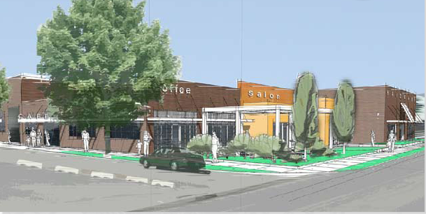
Stripcommercialcenter
Salt Lake
AH
Utah
49035C0282H
1-9
2023
0.70 AC
2023
Downtown
102900
Salt Lake City
18,120 SF
DEMOGRAPHICS near 1154 S 300 W
1 Mile
3 Mile
5 Mile
2024 Total Population
13,064
151,289
312,370
2029 Population
13,534
154,374
316,868
Pop Growth 2024-2029
+ 3.60%
+ 2.04%
+ 1.44%
Average Age
36
37
36
2024 Total Households
5,809
70,274
129,424
HH Growth 2024-2029
+ 4.15%
+ 2.49%
+ 1.79%
Median Household Inc
$51,424
$58,590
$62,713
Avg Household Size
2.10
2.00
2.30
2024 Avg HH Vehicles
1.00
1.00
2.00
Median Home Value
$390,489
$443,948
$443,502
Median Year Built
1993
1968
1972
Nearby Places
- Restaurants
- Banks
- Shops
- Fitness
- Groceries
PUBLIC TRANSPORTATION
TRANSIT/SUBWAY
Ballpark (TRAX Murray/Midvale/University Line - Utah Transit Authority (UTA), TRAX Salt Lake/Sandy Line - Utah Transit Authority (UTA))
DRIVE
WALK
Distance
Ballpark (TRAX Murray/Midvale/University Line - Utah Transit Authority (UTA), TRAX Salt Lake/Sandy Line - Utah Transit Authority (UTA))
2 min
6 min
0.3 mi
900 South (TRAX Murray/Midvale/University Line - Utah Transit Authority (UTA), TRAX Salt Lake/Sandy Line - Utah Transit Authority (UTA))
DRIVE
WALK
Distance
900 South (TRAX Murray/Midvale/University Line - Utah Transit Authority (UTA), TRAX Salt Lake/Sandy Line - Utah Transit Authority (UTA))
2 min
12 min
0.6 mi
COMMUTER RAIL
North Temple Station (FrontRunner - Utah Transit Authority (UTA))
DRIVE
WALK
Distance
North Temple Station (FrontRunner - Utah Transit Authority (UTA))
7 min
2.4 mi
Warm Springs Relief Point (FrontRunner - Utah Transit Authority (UTA))
DRIVE
WALK
Distance
Warm Springs Relief Point (FrontRunner - Utah Transit Authority (UTA))
9 min
4.7 mi
AIRPORT
Salt Lake City International
DRIVE
WALK
Distance
Salt Lake City International
12 min
7.3 mi
Freight Ports
Port of Stockton
DRIVE
WALK
Distance
Port of Stockton
712 min
697.6 mi
Nearby Properties
Address
Land Use
TOTAL SIZE
Lot Size
Zoning
Address
Land Use
TOTAL SIZE
Lot Size
Zoning
1,450,542 SF
9.72 AC
D-4
Address
Land Use
TOTAL SIZE
Lot Size
Zoning
1,573,360 SF
44.15 AC
I
Address
Land Use
TOTAL SIZE
Lot Size
Zoning
329,989 SF
33.64 AC
I
Address
Land Use
TOTAL SIZE
Lot Size
Zoning
268,830 SF
20.05 AC
1205
Address
Land Use
TOTAL SIZE
Lot Size
Zoning
56,741 SF
1.70 AC
D-1
Address
Land Use
TOTAL SIZE
Lot Size
Zoning
350,000 SF
10 AC
2000
Address
Land Use
TOTAL SIZE
Lot Size
Zoning
836,183 SF
5.89 AC
TSA-UC
Address
Land Use
TOTAL SIZE
Lot Size
Zoning
205,570 SF
5.63 AC
UI
Address
Land Use
TOTAL SIZE
Lot Size
Zoning
566,160 SF
4.14 AC
3000
Address
Land Use
TOTAL SIZE
Lot Size
Zoning
1,561,092 SF
3.50 AC
D-1
Address
Land Use
TOTAL SIZE
Lot Size
Zoning
296,978 SF
27.30 AC
I
Address
Land Use
TOTAL SIZE
Lot Size
Zoning
87,933 SF
4.90 AC
D-1
Address
Land Use
TOTAL SIZE
Lot Size
Zoning
1,779,694 SF
6.88 AC
D-1
Address
Land Use
TOTAL SIZE
Lot Size
Zoning
661,345 SF
0.01 AC
D1
Address
Land Use
TOTAL SIZE
Lot Size
Zoning
35,720 SF
0.55 AC
D-1
Address
Land Use
TOTAL SIZE
Lot Size
Zoning
737,755 SF
1.63 AC
D-1
Address
Land Use
TOTAL SIZE
Lot Size
Zoning
543,780 SF
0.33 AC
D1
Address
Land Use
TOTAL SIZE
Lot Size
Zoning
308,431 SF
38 AC
I
Address
Land Use
TOTAL SIZE
Lot Size
Zoning
163,932 SF
14.65 AC
PL
Address
Land Use
TOTAL SIZE
Lot Size
Zoning
82,851 SF
9.76 AC
PL2
Address
Land Use
TOTAL SIZE
Lot Size
Zoning
2,566,335 SF
10.01 AC
D-1
Address
Land Use
TOTAL SIZE
Lot Size
Zoning
497,018 SF
13.11 AC
1205
Address
Land Use
TOTAL SIZE
Lot Size
Zoning
449,528 SF
1.64 AC
2000
Address
Land Use
TOTAL SIZE
Lot Size
Zoning
366,584 SF
1.95 AC
TSAUC
Address
Land Use
TOTAL SIZE
Lot Size
Zoning
146,422 SF
2.62 AC
UI
Address
Land Use
TOTAL SIZE
Lot Size
Zoning
380,988 SF
1.64 AC
D-1
Address
Land Use
TOTAL SIZE
Lot Size
Zoning
542,678 SF
0.75 AC
X
Address
Land Use
TOTAL SIZE
Lot Size
Zoning
256,771 SF
2.33 AC
R-MU
Address
Land Use
TOTAL SIZE
Lot Size
Zoning
472,757 SF
3.20 AC
GMU
Address
Land Use
TOTAL SIZE
Lot Size
Zoning
1,330,057 SF
5.02 AC
D2
The World's #1 Commercial Real Estate Marketplace
Connect with us
© 2025 CoStar Group
The information above has been obtained from sources believed reliable. While we do not doubt its accuracy we have not verified it and make no guarantee, warranty or representation about it. It is your responsibility to independently confirm its accuracy and completeness. Any projections, opinions, assumptions, or estimates used are for example only and do not represent the current or future performance of the property. The value of this transaction to you depends on tax and other factors which should be evaluated by your tax, financial, and legal advisors. You and your advisors should conduct a careful, independent investigation of the property to determine to your satisfaction the suitability of the property for your needs.