Property Record
116 Purgatory Rd, Sutton, MA 01590
NEARBY LISTINGS FOR SALE OR LEASE
Property Detail
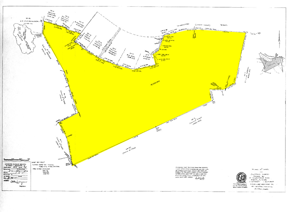
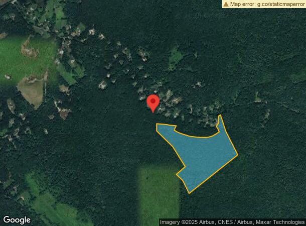
116 Purgatory Rd
SUTT-000032-000000-000002
Worcester
Stateproperty
Massachusetts
X
49.93 AC
25027C0840E
Outlying Worcester
0
Boston
2024
Worcester, MA-CT
751101
DEMOGRAPHICS near 116 Purgatory Rd
1 Mile
3 Mile
5 Mile
2024 Total Population
291
10,897
46,454
2029 Population
295
10,867
46,215
Pop Growth 2024-2029
+ 1.37%
(0.28%)
(0.51%)
Average Age
43
42
42
2024 Total Households
104
3,997
18,076
HH Growth 2024-2029
+ 1.92%
(0.33%)
(0.58%)
Median Household Inc
$154,167
$129,510
$110,346
Avg Household Size
2.70
2.70
2.50
2024 Avg HH Vehicles
2.00
2.00
2.00
Median Home Value
$549,020
$440,857
$409,156
Median Year Built
1981
1979
1975
Nearby Places
- Restaurants
- Banks
- Shops
- Fitness
- Groceries
PUBLIC TRANSPORTATION
AIRPORT
Worcester Regional
DRIVE
WALK
Distance
Worcester Regional
27 min
16.6 mi
Freight Ports
Port of Boston
DRIVE
WALK
Distance
Port of Boston
68 min
51.2 mi
Nearby Properties
Address
Land Use
TOTAL SIZE
Lot Size
Zoning
Address
Land Use
TOTAL SIZE
Lot Size
Zoning
200,557 SF
13.09 AC
R1
Address
Land Use
TOTAL SIZE
Lot Size
Zoning
161,541 SF
30.04 AC
Address
Land Use
TOTAL SIZE
Lot Size
Zoning
42.92 AC
R1
Address
Land Use
TOTAL SIZE
Lot Size
Zoning
423,649 SF
33.23 AC
B2
Address
Land Use
TOTAL SIZE
Lot Size
Zoning
607,486 SF
31.09 AC
OLI
Address
Land Use
TOTAL SIZE
Lot Size
Zoning
178,775 SF
36.78 AC
Address
Land Use
TOTAL SIZE
Lot Size
Zoning
10.19 AC
B2
Address
Land Use
TOTAL SIZE
Lot Size
Zoning
116,864 SF
16.87 AC
OLI
Address
Land Use
TOTAL SIZE
Lot Size
Zoning
136.75 AC
R1
Address
Land Use
TOTAL SIZE
Lot Size
Zoning
100,882 SF
25.60 AC
Address
Land Use
TOTAL SIZE
Lot Size
Zoning
107.27 AC
Address
Land Use
TOTAL SIZE
Lot Size
Zoning
109,500 SF
7.40 AC
V
Address
Land Use
TOTAL SIZE
Lot Size
Zoning
90,000 SF
9.40 AC
OLI
Address
Land Use
TOTAL SIZE
Lot Size
Zoning
29,851 SF
7.27 AC
OLI
Address
Land Use
TOTAL SIZE
Lot Size
Zoning
1,950 SF
506 AC
R1
Address
Land Use
TOTAL SIZE
Lot Size
Zoning
52,848 SF
7.02 AC
OLI
Address
Land Use
TOTAL SIZE
Lot Size
Zoning
159.46 AC
Address
Land Use
TOTAL SIZE
Lot Size
Zoning
9.60 AC
I
Address
Land Use
TOTAL SIZE
Lot Size
Zoning
27,918 SF
53.83 AC
OLI
Address
Land Use
TOTAL SIZE
Lot Size
Zoning
185,400 SF
16.35 AC
OLI
Address
Land Use
TOTAL SIZE
Lot Size
Zoning
18,450 SF
3.77 AC
B2
Address
Land Use
TOTAL SIZE
Lot Size
Zoning
3.50 AC
R1
Address
Land Use
TOTAL SIZE
Lot Size
Zoning
32,618 SF
4.36 AC
B2
Address
Land Use
TOTAL SIZE
Lot Size
Zoning
336,924 SF
37.33 AC
Address
Land Use
TOTAL SIZE
Lot Size
Zoning
86.84 AC
Address
Land Use
TOTAL SIZE
Lot Size
Zoning
255.31 AC
R1
Address
Land Use
TOTAL SIZE
Lot Size
Zoning
6,230 SF
2.52 AC
R1
Address
Land Use
TOTAL SIZE
Lot Size
Zoning
11.22 AC
V
Address
Land Use
TOTAL SIZE
Lot Size
Zoning
12,490 SF
3.32 AC
Address
Land Use
TOTAL SIZE
Lot Size
Zoning
4.41 AC
R1
The World's #1 Commercial Real Estate Marketplace
Connect with us
© 2025 CoStar Group
The information above has been obtained from sources believed reliable. While we do not doubt its accuracy we have not verified it and make no guarantee, warranty or representation about it. It is your responsibility to independently confirm its accuracy and completeness. Any projections, opinions, assumptions, or estimates used are for example only and do not represent the current or future performance of the property. The value of this transaction to you depends on tax and other factors which should be evaluated by your tax, financial, and legal advisors. You and your advisors should conduct a careful, independent investigation of the property to determine to your satisfaction the suitability of the property for your needs.