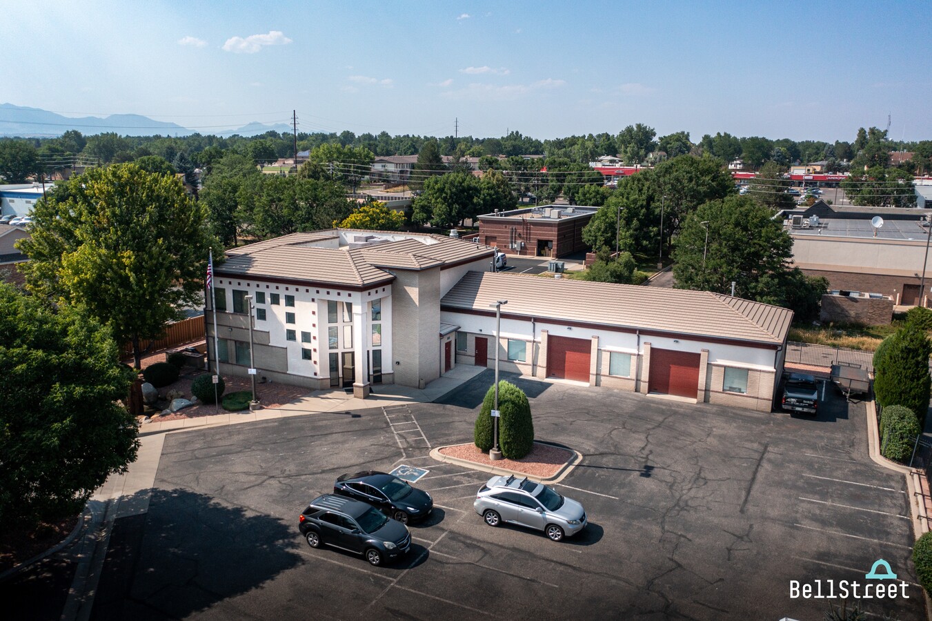
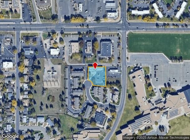
Property Record
11645 W 62Nd Pl, Arvada, CO 80004

Current Lease Availabilities
NEARBY LISTINGS FOR SALE OR LEASE
Property Detail
11645 W 62Nd Pl
Denver-Aurora-Lakewood, CO
Ralston Station Flg # 2 Amd Minor
39-081-01-039
SECTION 08 TOWNSHIP 03 RANGE 69 QTR NE SUBDIVISIONCD 626800 SUBDIVISIONNAME RALSTON STATION FLG # 2 AMD MINOR BLOCK LOT 0005 SIZE: 30000 TRACT VALUE: .689
Commercialnec
Jefferson
X
Colorado
08059C0192F
5
2023
0.69 AC
2024
Northwest Denver
010306
Denver
8,867 SF
DEMOGRAPHICS near 11645 W 62Nd Pl
1 Mile
3 Mile
5 Mile
2024 Total Population
16,402
92,838
220,708
2029 Population
16,211
91,904
219,033
Pop Growth 2024-2029
(1.16%)
(1.01%)
(0.76%)
Average Age
43
43
42
2024 Total Households
6,632
38,337
90,626
HH Growth 2024-2029
(1.36%)
(1.07%)
(0.77%)
Median Household Inc
$91,797
$96,454
$91,724
Avg Household Size
2.40
2.40
2.40
2024 Avg HH Vehicles
2.00
2.00
2.00
Median Home Value
$504,617
$583,864
$552,255
Median Year Built
1975
1978
1976
Nearby Places
- Restaurants
- Banks
- Shops
- Fitness
- Groceries
PUBLIC TRANSPORTATION
COMMUTER RAIL
Wheat Ridge - Ward Station Track 1 (Union Station to Wheat Ridge Ward Station - Regional Transportation District)
DRIVE
WALK
Distance
Wheat Ridge - Ward Station Track 1 (Union Station to Wheat Ridge Ward Station - Regional Transportation District)
6 min
2.5 mi
Arvada Ridge Station Track 1 (Union Station to Wheat Ridge Ward Station - Regional Transportation District)
DRIVE
WALK
Distance
Arvada Ridge Station Track 1 (Union Station to Wheat Ridge Ward Station - Regional Transportation District)
5 min
2.5 mi
AIRPORT
Denver International
DRIVE
WALK
Distance
Denver International
41 min
31.9 mi
Freight Ports
Tulsa Port Of Catoosa
DRIVE
WALK
Distance
Tulsa Port Of Catoosa
738 min
717.4 mi
Nearby Properties
Address
Land Use
TOTAL SIZE
Lot Size
Zoning
Address
Land Use
TOTAL SIZE
Lot Size
Zoning
830,160 SF
26.93 AC
Address
Land Use
TOTAL SIZE
Lot Size
Zoning
269,013 SF
31.89 AC
Address
Land Use
TOTAL SIZE
Lot Size
Zoning
253,643 SF
50.87 AC
A2
Address
Land Use
TOTAL SIZE
Lot Size
Zoning
365,230 SF
12.51 AC
Address
Land Use
TOTAL SIZE
Lot Size
Zoning
389,561 SF
10.73 AC
Address
Land Use
TOTAL SIZE
Lot Size
Zoning
215,878 SF
11.82 AC
A2
Address
Land Use
TOTAL SIZE
Lot Size
Zoning
131,135 SF
2.83 AC
Address
Land Use
TOTAL SIZE
Lot Size
Zoning
262,699 SF
13.10 AC
A2
Address
Land Use
TOTAL SIZE
Lot Size
Zoning
363,989 SF
30.10 AC
Address
Land Use
TOTAL SIZE
Lot Size
Zoning
101,761 SF
4.34 AC
Address
Land Use
TOTAL SIZE
Lot Size
Zoning
142,200 SF
9.82 AC
Address
Land Use
TOTAL SIZE
Lot Size
Zoning
149,115 SF
18 AC
Address
Land Use
TOTAL SIZE
Lot Size
Zoning
91,734 SF
9.69 AC
Address
Land Use
TOTAL SIZE
Lot Size
Zoning
113,903 SF
12.25 AC
Address
Land Use
TOTAL SIZE
Lot Size
Zoning
130,662 SF
9.67 AC
Address
Land Use
TOTAL SIZE
Lot Size
Zoning
33,506 SF
9.98 AC
A2
Address
Land Use
TOTAL SIZE
Lot Size
Zoning
82,055 SF
19.39 AC
Address
Land Use
TOTAL SIZE
Lot Size
Zoning
78,494 SF
5.68 AC
Address
Land Use
TOTAL SIZE
Lot Size
Zoning
68,300 SF
6 AC
Address
Land Use
TOTAL SIZE
Lot Size
Zoning
174,853 SF
14.68 AC
Address
Land Use
TOTAL SIZE
Lot Size
Zoning
169,525 SF
2.93 AC
Address
Land Use
TOTAL SIZE
Lot Size
Zoning
67,520 SF
6.46 AC
Address
Land Use
TOTAL SIZE
Lot Size
Zoning
51,987 SF
15.23 AC
PD
Address
Land Use
TOTAL SIZE
Lot Size
Zoning
83,684 SF
8.15 AC
Address
Land Use
TOTAL SIZE
Lot Size
Zoning
150,321 SF
6.52 AC
Address
Land Use
TOTAL SIZE
Lot Size
Zoning
224,923 SF
33.71 AC
Address
Land Use
TOTAL SIZE
Lot Size
Zoning
201,582 SF
5.78 AC
Address
Land Use
TOTAL SIZE
Lot Size
Zoning
22,524 SF
3.74 AC
Address
Land Use
TOTAL SIZE
Lot Size
Zoning
265,676 SF
2.03 AC
Address
Land Use
TOTAL SIZE
Lot Size
Zoning
67,879 SF
9.91 AC
A2
The World's #1 Commercial Real Estate Marketplace
Connect with us
© 2025 CoStar Group
The information above has been obtained from sources believed reliable. While we do not doubt its accuracy we have not verified it and make no guarantee, warranty or representation about it. It is your responsibility to independently confirm its accuracy and completeness. Any projections, opinions, assumptions, or estimates used are for example only and do not represent the current or future performance of the property. The value of this transaction to you depends on tax and other factors which should be evaluated by your tax, financial, and legal advisors. You and your advisors should conduct a careful, independent investigation of the property to determine to your satisfaction the suitability of the property for your needs.