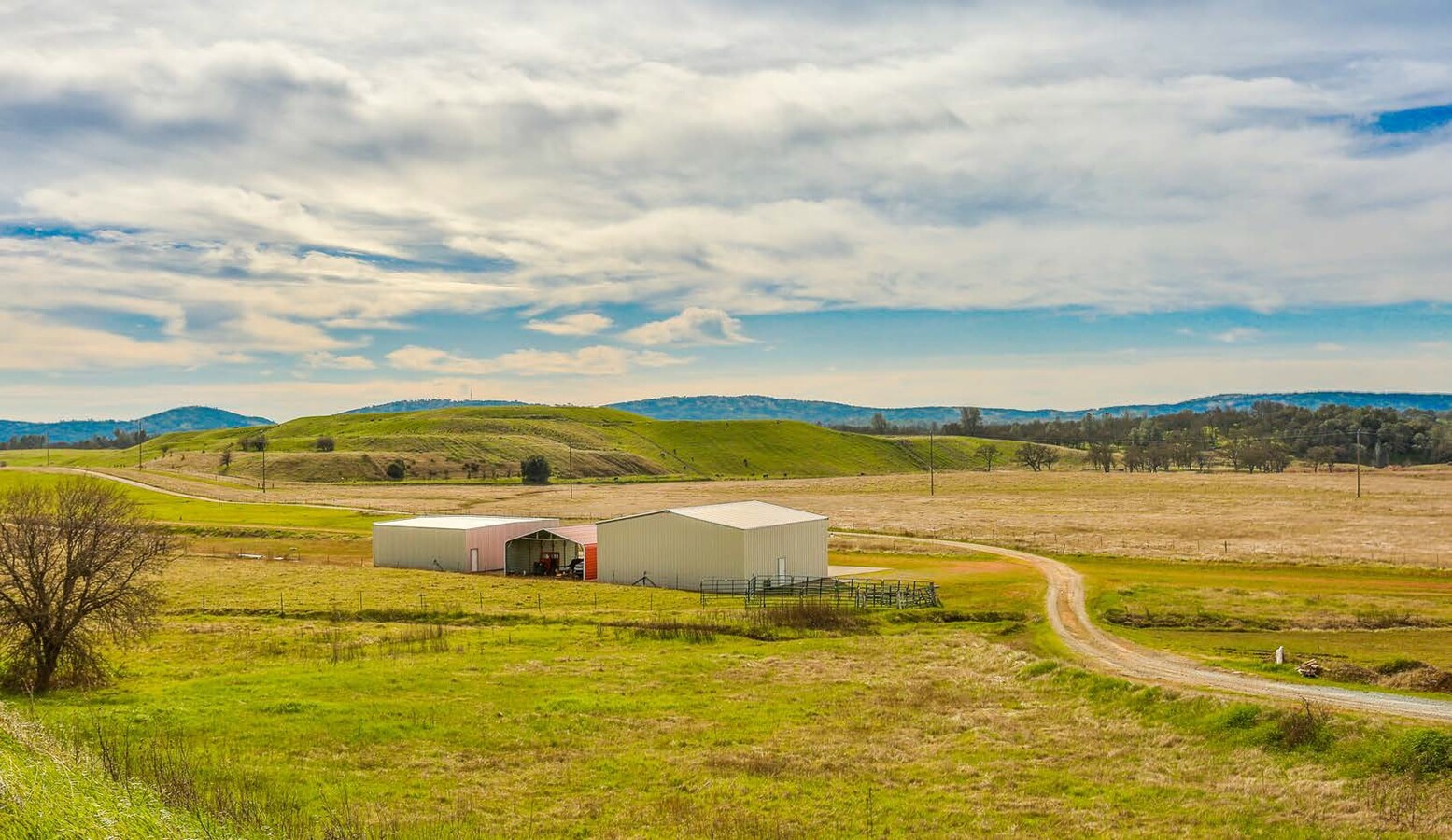
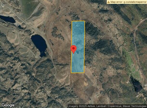
Property Record
1172 Hodson Rd, Copperopolis, CA 95228
NEARBY LISTINGS FOR SALE OR LEASE
-
-
View all Copperopolis listings for sale on LoopNet.com
Property Detail
1172 Hodson Rd
053-011-004-000
Township 2 North
Ranch
E2 OF E2 OF 29 T2R12
X
Calaveras
06009C0650E
California
2023
29
2023
160 AC
000123
Stockton/Modesto
1,156 SF
Other Market Areas
DEMOGRAPHICS near 1172 Hodson Rd
1 Mile
3 Mile
5 Mile
2024 Total Population
3
331
1,897
2029 Population
3
354
2,039
Pop Growth 2024-2029
0.00%
+ 6.95%
+ 7.49%
Average Age
0
45
45
2024 Total Households
1
130
752
HH Growth 2024-2029
0.00%
+ 6.15%
+ 6.91%
Median Household Inc
$0
$83,823
$85,294
Avg Household Size
.00
2.50
2.50
2024 Avg HH Vehicles
.00
3.00
3.00
Median Home Value
$750,000
$366,666
$376,035
Median Year Built
2005
1999
2000
Nearby Places
- Restaurants
- Banks
- Shops
- Fitness
- Groceries
SALE & LEASE HISTORY
LISTING DATE
SALE/LEASE

Feb 16, 2021
For Sale
Feb 12, 2020
For Sale
Nearby Properties
Address
Land Use
TOTAL SIZE
Lot Size
Zoning
Address
Land Use
TOTAL SIZE
Lot Size
Zoning
0.98 AC
C2
Address
Land Use
TOTAL SIZE
Lot Size
Zoning
3,755 SF
23.54 AC
U
Address
Land Use
TOTAL SIZE
Lot Size
Zoning
144.84 AC
A1
Address
Land Use
TOTAL SIZE
Lot Size
Zoning
3,700 SF
21.11 AC
RR15
Address
Land Use
TOTAL SIZE
Lot Size
Zoning
5,567 SF
17.65 AC
RR15
Address
Land Use
TOTAL SIZE
Lot Size
Zoning
2,528 SF
49.43 AC
A1
Address
Land Use
TOTAL SIZE
Lot Size
Zoning
3,556 SF
50.04 AC
A1
Address
Land Use
TOTAL SIZE
Lot Size
Zoning
2,989 SF
40 AC
A1
Address
Land Use
TOTAL SIZE
Lot Size
Zoning
3,304 SF
20.32 AC
RR15
Address
Land Use
TOTAL SIZE
Lot Size
Zoning
1,136 SF
20.02 AC
RR15
Address
Land Use
TOTAL SIZE
Lot Size
Zoning
3,525 SF
20.17 AC
A1
Address
Land Use
TOTAL SIZE
Lot Size
Zoning
2,910 SF
20.45 AC
RR15
Address
Land Use
TOTAL SIZE
Lot Size
Zoning
2,201 SF
20.04 AC
RR15
Address
Land Use
TOTAL SIZE
Lot Size
Zoning
2,982 SF
21.67 AC
RR15
Address
Land Use
TOTAL SIZE
Lot Size
Zoning
2,668 SF
21.33 AC
RR15
Address
Land Use
TOTAL SIZE
Lot Size
Zoning
0.48 AC
C2
Address
Land Use
TOTAL SIZE
Lot Size
Zoning
2,494 SF
20.01 AC
RR15
Address
Land Use
TOTAL SIZE
Lot Size
Zoning
3,087 SF
19.01 AC
RR15
Address
Land Use
TOTAL SIZE
Lot Size
Zoning
2,564 SF
17.88 AC
RR15
Address
Land Use
TOTAL SIZE
Lot Size
Zoning
1,560 SF
20.02 AC
RR15
Address
Land Use
TOTAL SIZE
Lot Size
Zoning
0.44 AC
C2
Address
Land Use
TOTAL SIZE
Lot Size
Zoning
100.19 AC
A1ME
Address
Land Use
TOTAL SIZE
Lot Size
Zoning
1,584 SF
20.82 AC
RR15
Address
Land Use
TOTAL SIZE
Lot Size
Zoning
2,475 SF
19.69 AC
U
Address
Land Use
TOTAL SIZE
Lot Size
Zoning
2,527 SF
5.07 AC
RR
Address
Land Use
TOTAL SIZE
Lot Size
Zoning
2,469 SF
19.19 AC
RR15
Address
Land Use
TOTAL SIZE
Lot Size
Zoning
2,476 SF
20 AC
RR15
Address
Land Use
TOTAL SIZE
Lot Size
Zoning
1,440 SF
18.87 AC
RR15
Address
Land Use
TOTAL SIZE
Lot Size
Zoning
2,491 SF
20 AC
RR15
The World's #1 Commercial Real Estate Marketplace
Connect with us
© 2025 CoStar Group
The information above has been obtained from sources believed reliable. While we do not doubt its accuracy we have not verified it and make no guarantee, warranty or representation about it. It is your responsibility to independently confirm its accuracy and completeness. Any projections, opinions, assumptions, or estimates used are for example only and do not represent the current or future performance of the property. The value of this transaction to you depends on tax and other factors which should be evaluated by your tax, financial, and legal advisors. You and your advisors should conduct a careful, independent investigation of the property to determine to your satisfaction the suitability of the property for your needs.