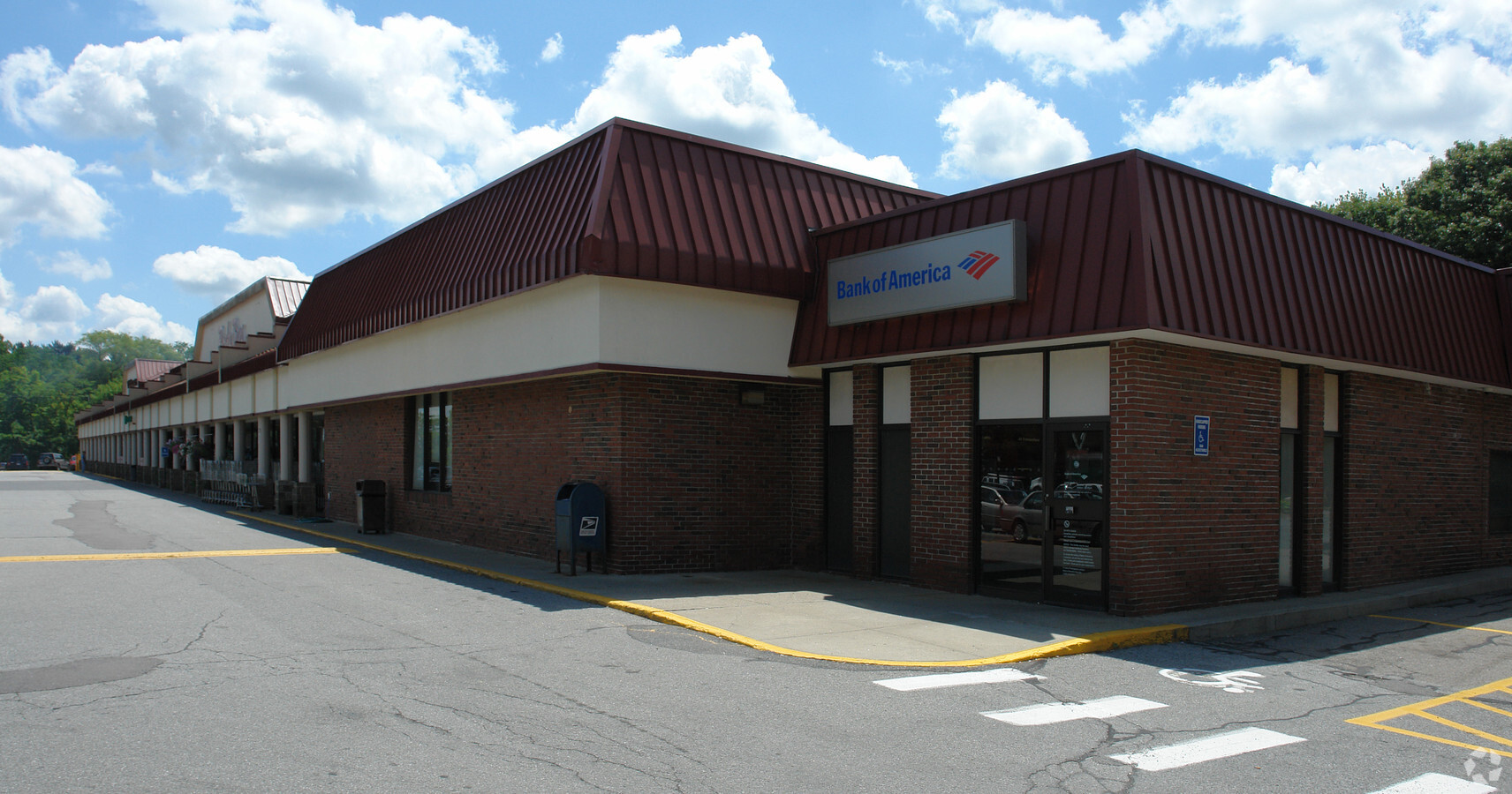
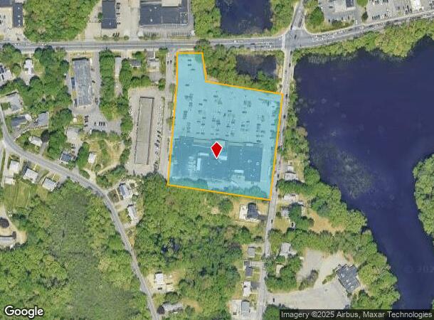
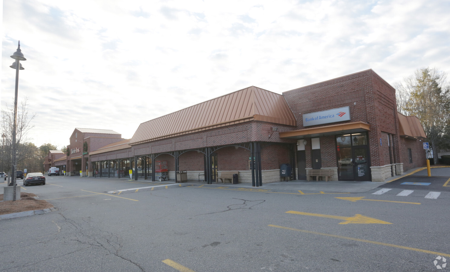
Property Record
118 Speen St, Natick, MA 01760
NEARBY LISTINGS FOR SALE OR LEASE
Property Detail
118 Speen St
Regionalshoppingcenterormallwithanchorstore
Middlesex
X
Massachusetts
25017C0517F
4.65 AC
2025
Framingham/Natick
2025
Boston
382500
Boston-Cambridge-Newton, MA-NH
52,288 SF
NATI-000041-000000-000097
DEMOGRAPHICS near 118 Speen St
1 Mile
3 Mile
5 Mile
2024 Total Population
9,216
74,912
154,976
2029 Population
9,062
74,232
153,819
Pop Growth 2024-2029
(1.67%)
(0.91%)
(0.75%)
Average Age
40
40
41
2024 Total Households
3,996
29,071
57,932
HH Growth 2024-2029
(1.90%)
(1.06%)
(0.85%)
Median Household Inc
$105,931
$96,064
$117,455
Avg Household Size
2.20
2.50
2.50
2024 Avg HH Vehicles
2.00
2.00
2.00
Median Home Value
$592,138
$647,893
$692,639
Median Year Built
1979
1962
1965
Nearby Places
- Restaurants
- Banks
- Shops
- Fitness
- Groceries
PUBLIC TRANSPORTATION
COMMUTER RAIL
West Natick (Framingham/Worcester Line - Massachusetts Bay Transportation Authority Commuter Rail (Purple Line))
DRIVE
WALK
Distance
West Natick (Framingham/Worcester Line - Massachusetts Bay Transportation Authority Commuter Rail (Purple Line))
2 min
17 min
0.9 mi
Natick (Framingham/Worcester Line - Massachusetts Bay Transportation Authority Commuter Rail (Purple Line))
DRIVE
WALK
Distance
Natick (Framingham/Worcester Line - Massachusetts Bay Transportation Authority Commuter Rail (Purple Line))
4 min
1.9 mi
AIRPORT
General Edward Lawrence Logan International
DRIVE
WALK
Distance
General Edward Lawrence Logan International
36 min
24.1 mi
Worcester Regional
DRIVE
WALK
Distance
Worcester Regional
51 min
33.8 mi
Freight Ports
Port of Boston
DRIVE
WALK
Distance
Port of Boston
35 min
22.5 mi
Nearby Properties
Address
Land Use
TOTAL SIZE
Lot Size
Zoning
Address
Land Use
TOTAL SIZE
Lot Size
Zoning
246,505 SF
6.48 AC
INII
Address
Land Use
TOTAL SIZE
Lot Size
Zoning
509,007 SF
22.26 AC
HM-I
Address
Land Use
TOTAL SIZE
Lot Size
Zoning
396,000 SF
44.41 AC
R-1
Address
Land Use
TOTAL SIZE
Lot Size
Zoning
304,444 SF
16.88 AC
INII
Address
Land Use
TOTAL SIZE
Lot Size
Zoning
478,440 SF
11.97 AC
B
Address
Land Use
TOTAL SIZE
Lot Size
Zoning
94,545 SF
11.70 AC
RSA
Address
Land Use
TOTAL SIZE
Lot Size
Zoning
188,746 SF
46.90 AC
RSA
Address
Land Use
TOTAL SIZE
Lot Size
Zoning
137,000 SF
18.96 AC
R-1
Address
Land Use
TOTAL SIZE
Lot Size
Zoning
837,977 SF
18.57 AC
M-1
Address
Land Use
TOTAL SIZE
Lot Size
Zoning
20,704 SF
13.36 AC
PCD
Address
Land Use
TOTAL SIZE
Lot Size
Zoning
315,055 SF
40.38 AC
G
Address
Land Use
TOTAL SIZE
Lot Size
Zoning
264,247 SF
6.09 AC
M-1
Address
Land Use
TOTAL SIZE
Lot Size
Zoning
269,426 SF
HM-II
Address
Land Use
TOTAL SIZE
Lot Size
Zoning
165,382 SF
12.46 AC
HPU
Address
Land Use
TOTAL SIZE
Lot Size
Zoning
122,748 SF
16.90 AC
HPU
Address
Land Use
TOTAL SIZE
Lot Size
Zoning
256,830 SF
12.61 AC
B
Address
Land Use
TOTAL SIZE
Lot Size
Zoning
207,522 SF
10.11 AC
B
Address
Land Use
TOTAL SIZE
Lot Size
Zoning
79.30 AC
RSA
Address
Land Use
TOTAL SIZE
Lot Size
Zoning
198,692 SF
2.60 AC
CII
Address
Land Use
TOTAL SIZE
Lot Size
Zoning
199,320 SF
16.65 AC
RSA
Address
Land Use
TOTAL SIZE
Lot Size
Zoning
251,366 SF
14.42 AC
G
Address
Land Use
TOTAL SIZE
Lot Size
Zoning
29,022 SF
4.89 AC
RG
Address
Land Use
TOTAL SIZE
Lot Size
Zoning
173,120 SF
15.29 AC
HM-I
Address
Land Use
TOTAL SIZE
Lot Size
Zoning
Address
Land Use
TOTAL SIZE
Lot Size
Zoning
182,736 SF
7.30 AC
B-2
Address
Land Use
TOTAL SIZE
Lot Size
Zoning
317,308 SF
10.04 AC
M
Address
Land Use
TOTAL SIZE
Lot Size
Zoning
73,257 SF
10.23 AC
RSA
Address
Land Use
TOTAL SIZE
Lot Size
Zoning
141,391 SF
9.15 AC
M
Address
Land Use
TOTAL SIZE
Lot Size
Zoning
350,935 SF
25.51 AC
M
Address
Land Use
TOTAL SIZE
Lot Size
Zoning
204,670 SF
12.55 AC
INI
The World's #1 Commercial Real Estate Marketplace
Connect with us
© 2025 CoStar Group
The information above has been obtained from sources believed reliable. While we do not doubt its accuracy we have not verified it and make no guarantee, warranty or representation about it. It is your responsibility to independently confirm its accuracy and completeness. Any projections, opinions, assumptions, or estimates used are for example only and do not represent the current or future performance of the property. The value of this transaction to you depends on tax and other factors which should be evaluated by your tax, financial, and legal advisors. You and your advisors should conduct a careful, independent investigation of the property to determine to your satisfaction the suitability of the property for your needs.