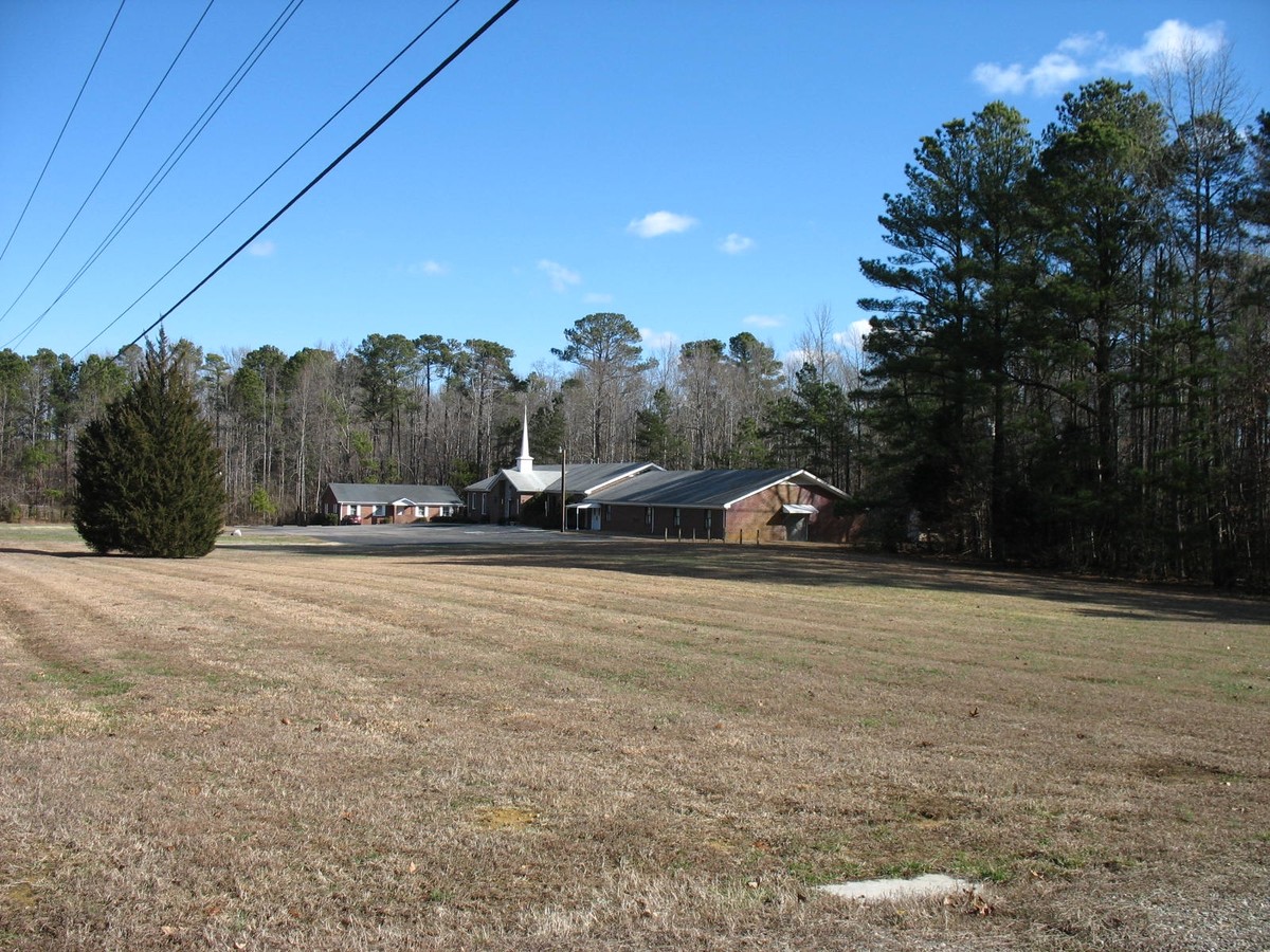
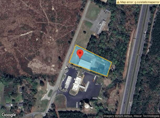
Property Record
11807 S Crater Rd, South Prince George, VA 23805

NEARBY LISTINGS FOR SALE OR LEASE
Property Detail
11807 S Crater Rd
430-0A-00-034-0
LEES MILL RD; ACRES:2.2006;
Commercialnec
Prince George
X
Virginia
51149C0175C
34
2024
2.20 AC
2024
Prince George
850501
Richmond VA
896 SF
Richmond, VA
DEMOGRAPHICS near 11807 S Crater Rd
1 Mile
3 Mile
5 Mile
2024 Total Population
840
6,770
22,839
2029 Population
843
6,702
22,462
Pop Growth 2024-2029
+ 0.36%
(1.00%)
(1.65%)
Average Age
44
43
42
2024 Total Households
336
2,841
9,780
HH Growth 2024-2029
+ 0.30%
(1.20%)
(1.79%)
Median Household Inc
$86,513
$68,513
$62,177
Avg Household Size
2.50
2.30
2.30
2024 Avg HH Vehicles
3.00
2.00
2.00
Median Home Value
$260,273
$195,435
$181,574
Median Year Built
1986
1984
1977
Nearby Places
- Restaurants
- Banks
- Shops
- Fitness
- Groceries
PUBLIC TRANSPORTATION
COMMUTER RAIL
Petersburg Amtrak Station (Carolinian - Amtrak, Northeast Regional - Amtrak, Palmetto - Amtrak, Silver Meteor - Amtrak, Silver Star - Amtrak)
DRIVE
WALK
Distance
Petersburg Amtrak Station (Carolinian - Amtrak, Northeast Regional - Amtrak, Palmetto - Amtrak, Silver Meteor - Amtrak, Silver Star - Amtrak)
14 min
8.8 mi
AIRPORT
Richmond International
DRIVE
WALK
Distance
Richmond International
42 min
33.7 mi
Freight Ports
Virginia Port Authority - Richmond
DRIVE
WALK
Distance
Virginia Port Authority - Richmond
36 min
25.1 mi
SALE & LEASE HISTORY
LISTING DATE
SALE/LEASE

Jun 30, 2017
For Sale
Nearby Properties
Address
Land Use
TOTAL SIZE
Lot Size
Zoning
Address
Land Use
TOTAL SIZE
Lot Size
Zoning
24.02 AC
B-2C
Address
Land Use
TOTAL SIZE
Lot Size
Zoning
220.52 AC
R1
Address
Land Use
TOTAL SIZE
Lot Size
Zoning
67,456 SF
512.10 AC
A2
Address
Land Use
TOTAL SIZE
Lot Size
Zoning
17.09 AC
PUD
Address
Land Use
TOTAL SIZE
Lot Size
Zoning
11.56 AC
PUD
Address
Land Use
TOTAL SIZE
Lot Size
Zoning
42,561 SF
6.91 AC
B-2C
Address
Land Use
TOTAL SIZE
Lot Size
Zoning
151,980 SF
23.12 AC
PUD
Address
Land Use
TOTAL SIZE
Lot Size
Zoning
1.09 AC
PUD
Address
Land Use
TOTAL SIZE
Lot Size
Zoning
8.72 AC
PUD
Address
Land Use
TOTAL SIZE
Lot Size
Zoning
102,424 SF
14.71 AC
PUD
Address
Land Use
TOTAL SIZE
Lot Size
Zoning
84,064 SF
15.54 AC
PUD
Address
Land Use
TOTAL SIZE
Lot Size
Zoning
9.72 AC
RA
Address
Land Use
TOTAL SIZE
Lot Size
Zoning
68,718 SF
2.33 AC
11
Address
Land Use
TOTAL SIZE
Lot Size
Zoning
33,360 SF
0.45 AC
B-2C
Address
Land Use
TOTAL SIZE
Lot Size
Zoning
44,311 SF
9.05 AC
R-1
Address
Land Use
TOTAL SIZE
Lot Size
Zoning
39,886 SF
2.74 AC
11
Address
Land Use
TOTAL SIZE
Lot Size
Zoning
8 AC
PUD
Address
Land Use
TOTAL SIZE
Lot Size
Zoning
58,986 SF
3.83 AC
11
Address
Land Use
TOTAL SIZE
Lot Size
Zoning
76,005 SF
16.13 AC
PUD
Address
Land Use
TOTAL SIZE
Lot Size
Zoning
40,884 SF
2.50 AC
Address
Land Use
TOTAL SIZE
Lot Size
Zoning
85,838 SF
10.18 AC
B-2C
Address
Land Use
TOTAL SIZE
Lot Size
Zoning
44.11 AC
M-2
Address
Land Use
TOTAL SIZE
Lot Size
Zoning
42,384 SF
1.49 AC
B-2
Address
Land Use
TOTAL SIZE
Lot Size
Zoning
37,211 SF
2.72 AC
11
Address
Land Use
TOTAL SIZE
Lot Size
Zoning
250 AC
R-1
Address
Land Use
TOTAL SIZE
Lot Size
Zoning
25,884 SF
152.42 AC
Address
Land Use
TOTAL SIZE
Lot Size
Zoning
18,180 SF
2.09 AC
R-5
Address
Land Use
TOTAL SIZE
Lot Size
Zoning
17,300 SF
2.26 AC
A
Address
Land Use
TOTAL SIZE
Lot Size
Zoning
33,967 SF
3.48 AC
R-5
Address
Land Use
TOTAL SIZE
Lot Size
Zoning
39,364 SF
9.75 AC
The World's #1 Commercial Real Estate Marketplace
Connect with us
© 2025 CoStar Group
The information above has been obtained from sources believed reliable. While we do not doubt its accuracy we have not verified it and make no guarantee, warranty or representation about it. It is your responsibility to independently confirm its accuracy and completeness. Any projections, opinions, assumptions, or estimates used are for example only and do not represent the current or future performance of the property. The value of this transaction to you depends on tax and other factors which should be evaluated by your tax, financial, and legal advisors. You and your advisors should conduct a careful, independent investigation of the property to determine to your satisfaction the suitability of the property for your needs.