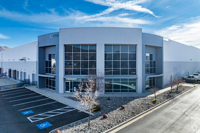
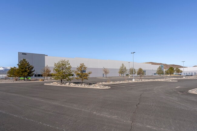
Property Record
1190 Trademark Dr, Reno, NV 89521


Property Detail
1190 Trademark Dr
163-020-10
PM 3201 ADJ LT F2 (RS 3449)
Industrialgeneral
Washoe
PD
Nevada
A Areas with a 1% annual chance of flooding and a 26% chance of flooding over the life of a 30-year mortgage.
f2
2025
23.50 AC
2026
South Reno
002214
Reno/Sparks
394,767 SF
Reno, NV
NEARBY LISTINGS FOR SALE OR LEASE
DEMOGRAPHICS near 1190 Trademark Dr
1 mile
3 mile
5 mile
2025 Total Population
7,743
57,141
116,701
2030 Population
7,996
58,804
120,251
Pop Growth 2025-2030
+ 3.27%
+ 2.91%
+ 3.04%
Average Age
39
41
41
2025 Total Households
3,003
23,611
47,899
HH Growth 2025-2030
+ 3.60%
+ 2.98%
+ 3.10%
Median Household Inc
$131,623
$100,994
$89,209
Avg Household Size
2.50
2.40
2.40
2025 Avg HH Vehicles
2.00
2.00
2.00
Median Home Value
$675,675
$643,751
$677,014
Median Year Built
2006
2000
1993
Nearby Places
Map Layers
Map Styles
 Street
 Aerial
Layers
 Traffic
 Biking
Places
Listings with unknown addresses are not visible on the map
- Restaurants
- Banks
- Shops
- Fitness
- Groceries
PUBLIC TRANSPORTATION
AIRPORT
Reno/Tahoe International
Drive
Walk
Distance
Reno/Tahoe International
31 min
10.7 mi
SALE & LEASE HISTORY
LISTING DATE
SALE/LEASE

Oct 29, 2025
For Lease
Nov 16, 2017
For Lease
May 20, 2025
For Lease
Mar 31, 2025
For Lease
Mar 06, 2017
For Lease
Jan 16, 2018
For Lease
Feb 12, 2024
For Lease
Nearby Properties
Address
Land Use
TOTAL SIZE
Lot Size
Zoning
Address
Land Use
TOTAL SIZE
Lot Size
Zoning
390,743 SF
22.20 AC
IC
Address
Land Use
TOTAL SIZE
Lot Size
Zoning
1,051,043 SF
78.81 AC
PD
Address
Land Use
TOTAL SIZE
Lot Size
Zoning
425,118 SF
30.37 AC
IC
Address
Land Use
TOTAL SIZE
Lot Size
Zoning
271,546 SF
20.62 AC
PD
Address
Land Use
TOTAL SIZE
Lot Size
Zoning
893,055 SF
52.71 AC
MA
Address
Land Use
TOTAL SIZE
Lot Size
Zoning
476,624 SF
19.33 AC
PD
Address
Land Use
TOTAL SIZE
Lot Size
Zoning
451,635 SF
15 AC
PD
Address
Land Use
TOTAL SIZE
Lot Size
Zoning
418,177 SF
16.59 AC
MS
Address
Land Use
TOTAL SIZE
Lot Size
Zoning
421,744 SF
12.07 AC
MS
Address
Land Use
TOTAL SIZE
Lot Size
Zoning
308,769 SF
17.53 AC
PD
Address
Land Use
TOTAL SIZE
Lot Size
Zoning
389,745 SF
15.17 AC
MS
Address
Land Use
TOTAL SIZE
Lot Size
Zoning
500,079 SF
45.66 AC
SPD
Address
Land Use
TOTAL SIZE
Lot Size
Zoning
327,867 SF
12.11 AC
PD
Address
Land Use
TOTAL SIZE
Lot Size
Zoning
181,150 SF
27.71 AC
PD
Address
Land Use
TOTAL SIZE
Lot Size
Zoning
476,624 SF
19.50 AC
PD
Address
Land Use
TOTAL SIZE
Lot Size
Zoning
310,004 SF
11.77 AC
PD
Address
Land Use
TOTAL SIZE
Lot Size
Zoning
283,103 SF
10.02 AC
PD
Address
Land Use
TOTAL SIZE
Lot Size
Zoning
276,780 SF
60.26 AC
PD
Address
Land Use
TOTAL SIZE
Lot Size
Zoning
335,490 SF
19.54 AC
PD
Address
Land Use
TOTAL SIZE
Lot Size
Zoning
392,820 SF
24.82 AC
MS
Address
Land Use
TOTAL SIZE
Lot Size
Zoning
342,019 SF
23.32 AC
MF14
Address
Land Use
TOTAL SIZE
Lot Size
Zoning
365,634 SF
19.70 AC
MF21
Address
Land Use
TOTAL SIZE
Lot Size
Zoning
151,254 SF
48.11 AC
MDS
Address
Land Use
TOTAL SIZE
Lot Size
Zoning
389,667 SF
19.52 AC
MS
Address
Land Use
TOTAL SIZE
Lot Size
Zoning
240,094 SF
8.16 AC
MS
Address
Land Use
TOTAL SIZE
Lot Size
Zoning
209,359 SF
10.98 AC
PD
Address
Land Use
TOTAL SIZE
Lot Size
Zoning
601,250 SF
27.39 AC
MS
Address
Land Use
TOTAL SIZE
Lot Size
Zoning
212,660 SF
5.21 AC
MS
Address
Land Use
TOTAL SIZE
Lot Size
Zoning
187,900 SF
14.83 AC
PD
Address
Land Use
TOTAL SIZE
Lot Size
Zoning
284,689 SF
10.63 AC
MS
The World's #1 Commercial Real Estate Marketplace
Connect with us
© 2026 CoStar Group
The information above has been obtained from sources believed reliable. While we do not doubt its accuracy we have not verified it and make no guarantee, warranty or representation about it. It is your responsibility to independently confirm its accuracy and completeness. Any projections, opinions, assumptions, or estimates used are for example only and do not represent the current or future performance of the property. The value of this transaction to you depends on tax and other factors which should be evaluated by your tax, financial, and legal advisors. You and your advisors should conduct a careful, independent investigation of the property to determine to your satisfaction the suitability of the property for your needs.