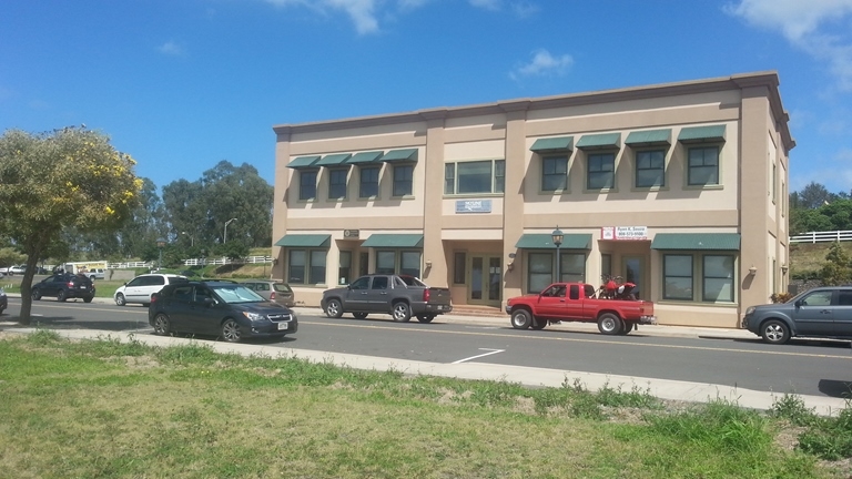
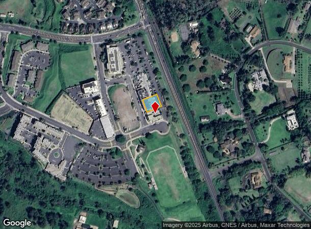
Property Record
12 Kiopaa Pl, Makawao, HI 96768
NEARBY LISTINGS FOR SALE OR LEASE
-
-
View all Makawao listings for sale on LoopNet.com
Property Detail
12 Kiopaa Pl
Kahului-Wailuku-Lahaina, HI
Kulamalu Mauka Subdivision
2-2-3-066-030-0000
LOT 11 KULAMALU MAUKA SUBDIVISION POR RP GR 1167 10,109 SF DES TOG/ESMT SUBJ/ESMT
Commercialnec
Maui
X
Hawaii
1500030625E
11
2024
0.23 AC
2024
Upcountry Maui
030406
Hawaii
7,092 SF
DEMOGRAPHICS near 12 Kiopaa Pl
1 Mile
3 Mile
5 Mile
2024 Total Population
1,766
16,857
22,916
2029 Population
1,725
16,396
22,247
Pop Growth 2024-2029
(2.32%)
(2.73%)
(2.92%)
Average Age
43
42
43
2024 Total Households
621
5,842
7,992
HH Growth 2024-2029
(3.22%)
(3.63%)
(3.78%)
Median Household Inc
$98,059
$92,223
$90,269
Avg Household Size
2.70
2.70
2.70
2024 Avg HH Vehicles
2.00
2.00
2.00
Median Home Value
$823,592
$781,618
$817,830
Median Year Built
1981
1980
1980
Nearby Places
- Restaurants
- Banks
- Shops
- Fitness
- Groceries
PUBLIC TRANSPORTATION
AIRPORT
Kahului
DRIVE
WALK
Distance
Kahului
16 min
9.5 mi
Nearby Properties
Address
Land Use
TOTAL SIZE
Lot Size
Zoning
Address
Land Use
TOTAL SIZE
Lot Size
Zoning
25,771 SF
2.79 AC
B-CT
Address
Land Use
TOTAL SIZE
Lot Size
Zoning
69,656 SF
6.49 AC
B-2
Address
Land Use
TOTAL SIZE
Lot Size
Zoning
26,154 SF
4.18 AC
B-CT
Address
Land Use
TOTAL SIZE
Lot Size
Zoning
5,924 SF
79.65 AC
2
Address
Land Use
TOTAL SIZE
Lot Size
Zoning
16,069 SF
1.98 AC
STATE URB
Address
Land Use
TOTAL SIZE
Lot Size
Zoning
0.49 AC
Address
Land Use
TOTAL SIZE
Lot Size
Zoning
0.46 AC
Address
Land Use
TOTAL SIZE
Lot Size
Zoning
13,824 SF
1.45 AC
2
Address
Land Use
TOTAL SIZE
Lot Size
Zoning
1.09 AC
OS
Address
Land Use
TOTAL SIZE
Lot Size
Zoning
15,397 SF
1.48 AC
2
Address
Land Use
TOTAL SIZE
Lot Size
Zoning
30.46 AC
A-1
Address
Land Use
TOTAL SIZE
Lot Size
Zoning
12,624 SF
15.37 AC
AGR
Address
Land Use
TOTAL SIZE
Lot Size
Zoning
0.33 AC
Address
Land Use
TOTAL SIZE
Lot Size
Zoning
14,942 SF
1.11 AC
R-3
Address
Land Use
TOTAL SIZE
Lot Size
Zoning
21,920 SF
1.14 AC
INTERIM
Address
Land Use
TOTAL SIZE
Lot Size
Zoning
15,040 SF
0.77 AC
2
Address
Land Use
TOTAL SIZE
Lot Size
Zoning
4,559 SF
0.46 AC
B-CT
Address
Land Use
TOTAL SIZE
Lot Size
Zoning
14,820 SF
0.64 AC
URBAN
Address
Land Use
TOTAL SIZE
Lot Size
Zoning
40.59 AC
SMA NONE
Address
Land Use
TOTAL SIZE
Lot Size
Zoning
7,499 SF
3.91 AC
COUNTY AG
Address
Land Use
TOTAL SIZE
Lot Size
Zoning
0.50 AC
2
Address
Land Use
TOTAL SIZE
Lot Size
Zoning
6,716 SF
2 AC
AGR
Address
Land Use
TOTAL SIZE
Lot Size
Zoning
1.52 AC
B-CT
Address
Land Use
TOTAL SIZE
Lot Size
Zoning
6 AC
AGR
Address
Land Use
TOTAL SIZE
Lot Size
Zoning
20.98 AC
SMA NONE
Address
Land Use
TOTAL SIZE
Lot Size
Zoning
1,381 SF
1.90 AC
Address
Land Use
TOTAL SIZE
Lot Size
Zoning
7,202 SF
0.24 AC
2
Address
Land Use
TOTAL SIZE
Lot Size
Zoning
4,730 SF
1.52 AC
B-CT
Address
Land Use
TOTAL SIZE
Lot Size
Zoning
5,097 SF
0.64 AC
URBAN
Address
Land Use
TOTAL SIZE
Lot Size
Zoning
1.20 AC
The World's #1 Commercial Real Estate Marketplace
Connect with us
© 2025 CoStar Group
The information above has been obtained from sources believed reliable. While we do not doubt its accuracy we have not verified it and make no guarantee, warranty or representation about it. It is your responsibility to independently confirm its accuracy and completeness. Any projections, opinions, assumptions, or estimates used are for example only and do not represent the current or future performance of the property. The value of this transaction to you depends on tax and other factors which should be evaluated by your tax, financial, and legal advisors. You and your advisors should conduct a careful, independent investigation of the property to determine to your satisfaction the suitability of the property for your needs.