No Photo
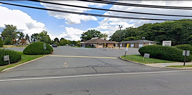
Property Record
12 Main St, Robbinsville, NJ 08691


Current Lease Availabilities
NEARBY LISTINGS FOR SALE OR LEASE
Property Detail
12 Main St
Trenton, NJ
CORESTATES
12-00002-0000-00007
Mercer
Financialbuilding
New Jersey
X
7
34021C0253F
1.58 AC
2024
Trenton
2025
Northern New Jersey
004311
DEMOGRAPHICS near 12 Main St
1 Mile
3 Mile
5 Mile
2024 Total Population
7,379
34,419
102,391
2029 Population
7,385
34,026
100,962
Pop Growth 2024-2029
+ 0.08%
(1.14%)
(1.40%)
Average Age
39
43
43
2024 Total Households
2,766
12,998
38,577
HH Growth 2024-2029
+ 0.07%
(1.31%)
(1.61%)
Median Household Inc
$147,946
$123,755
$107,840
Avg Household Size
2.70
2.60
2.50
2024 Avg HH Vehicles
2.00
2.00
2.00
Median Home Value
$414,017
$350,482
$330,442
Median Year Built
1995
1983
1973
Nearby Places
Map Layers
Map Styles
 Street
 Aerial
- Restaurants
- Banks
- Shops
- Fitness
- Groceries
PUBLIC TRANSPORTATION
COMMUTER RAIL
Hamilton (Northeast Corridor Line - NJ Transit Commuter Rail (NJ Transit))
DRIVE
WALK
Distance
Hamilton (Northeast Corridor Line - NJ Transit Commuter Rail (NJ Transit))
13 min
6.0 mi
Trenton Transit Center (NJT) (Northeast Corridor Line - NJ Transit Commuter Rail (NJ Transit), River LINE - River LINE (River LINE))
DRIVE
WALK
Distance
Trenton Transit Center (NJT) (Northeast Corridor Line - NJ Transit Commuter Rail (NJ Transit), River LINE - River LINE (River LINE))
17 min
7.7 mi
AIRPORT
Trenton Mercer
DRIVE
WALK
Distance
Trenton Mercer
26 min
15.8 mi
Freight Ports
South Jersey Port
DRIVE
WALK
Distance
South Jersey Port
50 min
37.0 mi
Nearby Properties
Address
Land Use
TOTAL SIZE
Lot Size
Zoning
Address
Land Use
TOTAL SIZE
Lot Size
Zoning
31.05 AC
Address
Land Use
TOTAL SIZE
Lot Size
Zoning
23.13 AC
RD
Address
Land Use
TOTAL SIZE
Lot Size
Zoning
55.71 AC
PCD
Address
Land Use
TOTAL SIZE
Lot Size
Zoning
64.43 AC
PCD
Address
Land Use
TOTAL SIZE
Lot Size
Zoning
30.94 AC
Address
Land Use
TOTAL SIZE
Lot Size
Zoning
60.26 AC
RD
Address
Land Use
TOTAL SIZE
Lot Size
Zoning
65.18 AC
PCD
Address
Land Use
TOTAL SIZE
Lot Size
Zoning
44.82 AC
RD
Address
Land Use
TOTAL SIZE
Lot Size
Zoning
2,030 SF
45.57 AC
Address
Land Use
TOTAL SIZE
Lot Size
Zoning
Address
Land Use
TOTAL SIZE
Lot Size
Zoning
18.33 AC
Address
Land Use
TOTAL SIZE
Lot Size
Zoning
17.84 AC
HC
Address
Land Use
TOTAL SIZE
Lot Size
Zoning
47.91 AC
PCD
Address
Land Use
TOTAL SIZE
Lot Size
Zoning
23.13 AC
RR
Address
Land Use
TOTAL SIZE
Lot Size
Zoning
56.90 AC
RD
Address
Land Use
TOTAL SIZE
Lot Size
Zoning
134,000 SF
117.90 AC
AR
Address
Land Use
TOTAL SIZE
Lot Size
Zoning
37.90 AC
PCD
Address
Land Use
TOTAL SIZE
Lot Size
Zoning
50.05 AC
RR
Address
Land Use
TOTAL SIZE
Lot Size
Zoning
1,836 SF
33.91 AC
RD
Address
Land Use
TOTAL SIZE
Lot Size
Zoning
9.63 AC
RD
Address
Land Use
TOTAL SIZE
Lot Size
Zoning
22.91 AC
PCD
Address
Land Use
TOTAL SIZE
Lot Size
Zoning
15.80 AC
C
Address
Land Use
TOTAL SIZE
Lot Size
Zoning
30.70 AC
PCD
Address
Land Use
TOTAL SIZE
Lot Size
Zoning
21.62 AC
RD
Address
Land Use
TOTAL SIZE
Lot Size
Zoning
Address
Land Use
TOTAL SIZE
Lot Size
Zoning
38.78 AC
PCD
Address
Land Use
TOTAL SIZE
Lot Size
Zoning
46.35 AC
PCD
Address
Land Use
TOTAL SIZE
Lot Size
Zoning
60,564 SF
18.37 AC
RD
Address
Land Use
TOTAL SIZE
Lot Size
Zoning
77,722 SF
39.13 AC
Address
Land Use
TOTAL SIZE
Lot Size
Zoning
17.06 AC
RD
The World's #1 Commercial Real Estate Marketplace
Connect with us
© 2025 CoStar Group
The information above has been obtained from sources believed reliable. While we do not doubt its accuracy we have not verified it and make no guarantee, warranty or representation about it. It is your responsibility to independently confirm its accuracy and completeness. Any projections, opinions, assumptions, or estimates used are for example only and do not represent the current or future performance of the property. The value of this transaction to you depends on tax and other factors which should be evaluated by your tax, financial, and legal advisors. You and your advisors should conduct a careful, independent investigation of the property to determine to your satisfaction the suitability of the property for your needs.