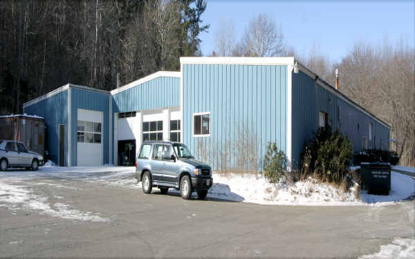
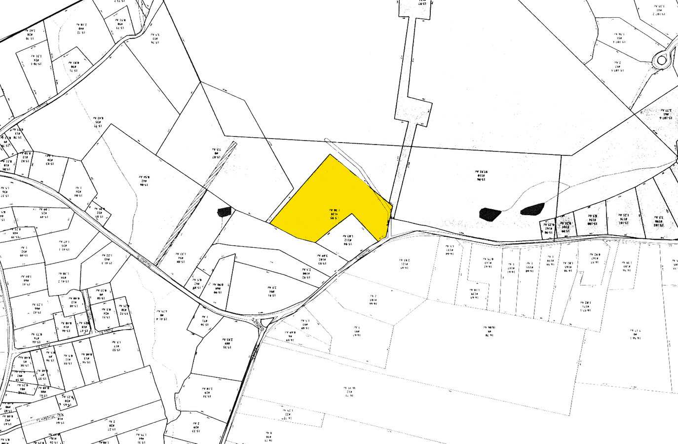
Property Record
120 Haverhill St, Rowley, MA 01969
NEARBY LISTINGS FOR SALE OR LEASE
-
-
View all Rowley listings for sale on LoopNet.com
Property Detail
120 Haverhill St
ROWL-000015-000095
Casablancaa Twnhs
Manufacturinglight
Essex
X
Massachusetts
25009C0259F
1.58 AC
2025
Amesbury/Ipswich
2025
Boston
270100
Boston-Cambridge-Newton, MA-NH
15,440 SF
DEMOGRAPHICS near 120 Haverhill St
1 Mile
3 Mile
5 Mile
2024 Total Population
1,916
11,874
31,556
2029 Population
1,914
11,872
31,552
Pop Growth 2024-2029
(0.10%)
(0.02%)
(0.01%)
Average Age
44
44
44
2024 Total Households
720
4,416
12,312
HH Growth 2024-2029
(0.28%)
(0.18%)
(0.14%)
Median Household Inc
$129,375
$136,544
$127,545
Avg Household Size
2.70
2.70
2.50
2024 Avg HH Vehicles
2.00
2.00
2.00
Median Home Value
$665,865
$679,655
$676,883
Median Year Built
1980
1981
1974
Nearby Places
- Restaurants
- Banks
- Shops
- Fitness
- Groceries
PUBLIC TRANSPORTATION
COMMUTER RAIL
Rowley (Newburyport/Rockport Line - Massachusetts Bay Transportation Authority Commuter Rail (Purple Line))
DRIVE
WALK
Distance
Rowley (Newburyport/Rockport Line - Massachusetts Bay Transportation Authority Commuter Rail (Purple Line))
7 min
2.5 mi
Ipswich (Newburyport/Rockport Line - Massachusetts Bay Transportation Authority Commuter Rail (Purple Line))
DRIVE
WALK
Distance
Ipswich (Newburyport/Rockport Line - Massachusetts Bay Transportation Authority Commuter Rail (Purple Line))
10 min
4.4 mi
AIRPORT
General Edward Lawrence Logan International
DRIVE
WALK
Distance
General Edward Lawrence Logan International
47 min
28.4 mi
Portsmouth International at Pease
DRIVE
WALK
Distance
Portsmouth International at Pease
46 min
31.2 mi
Freight Ports
Port of Boston
DRIVE
WALK
Distance
Port of Boston
50 min
31.4 mi
Nearby Properties
Address
Land Use
TOTAL SIZE
Lot Size
Zoning
Address
Land Use
TOTAL SIZE
Lot Size
Zoning
1,520 AC
RRA
Address
Land Use
TOTAL SIZE
Lot Size
Zoning
22.90 AC
HB
Address
Land Use
TOTAL SIZE
Lot Size
Zoning
86,812 SF
27.80 AC
Address
Land Use
TOTAL SIZE
Lot Size
Zoning
106,342 SF
22.38 AC
Address
Land Use
TOTAL SIZE
Lot Size
Zoning
284.17 AC
RRA
Address
Land Use
TOTAL SIZE
Lot Size
Zoning
2,394 SF
63.04 AC
Address
Land Use
TOTAL SIZE
Lot Size
Zoning
130,204 SF
40.90 AC
Address
Land Use
TOTAL SIZE
Lot Size
Zoning
55,946 SF
20.50 AC
Address
Land Use
TOTAL SIZE
Lot Size
Zoning
108,934 SF
7.64 AC
LI
Address
Land Use
TOTAL SIZE
Lot Size
Zoning
36,838 SF
13.93 AC
HB
Address
Land Use
TOTAL SIZE
Lot Size
Zoning
1,863 SF
9.67 AC
RRA
Address
Land Use
TOTAL SIZE
Lot Size
Zoning
90,855 SF
16.19 AC
Address
Land Use
TOTAL SIZE
Lot Size
Zoning
1,035 AC
RRA
Address
Land Use
TOTAL SIZE
Lot Size
Zoning
78,740 SF
14.54 AC
Address
Land Use
TOTAL SIZE
Lot Size
Zoning
10,255 SF
6.39 AC
Address
Land Use
TOTAL SIZE
Lot Size
Zoning
83.80 AC
AR4
Address
Land Use
TOTAL SIZE
Lot Size
Zoning
14,240 SF
51.38 AC
PC
Address
Land Use
TOTAL SIZE
Lot Size
Zoning
3.70 AC
PC
Address
Land Use
TOTAL SIZE
Lot Size
Zoning
64,500 SF
6.93 AC
PC
Address
Land Use
TOTAL SIZE
Lot Size
Zoning
264 SF
232.27 AC
PC
Address
Land Use
TOTAL SIZE
Lot Size
Zoning
46,186 SF
9.08 AC
RRA
Address
Land Use
TOTAL SIZE
Lot Size
Zoning
5.40 AC
RRA
Address
Land Use
TOTAL SIZE
Lot Size
Zoning
56,998 SF
17.23 AC
RRA
Address
Land Use
TOTAL SIZE
Lot Size
Zoning
57,400 SF
7.79 AC
LI
Address
Land Use
TOTAL SIZE
Lot Size
Zoning
2,286 SF
3.82 AC
Address
Land Use
TOTAL SIZE
Lot Size
Zoning
19,665 SF
17.01 AC
PC
Address
Land Use
TOTAL SIZE
Lot Size
Zoning
194.58 AC
RRC
Address
Land Use
TOTAL SIZE
Lot Size
Zoning
15.50 AC
AR4
Address
Land Use
TOTAL SIZE
Lot Size
Zoning
1,500 SF
7.55 AC
RRA
Address
Land Use
TOTAL SIZE
Lot Size
Zoning
3.21 AC
HB
The World's #1 Commercial Real Estate Marketplace
Connect with us
© 2025 CoStar Group
The information above has been obtained from sources believed reliable. While we do not doubt its accuracy we have not verified it and make no guarantee, warranty or representation about it. It is your responsibility to independently confirm its accuracy and completeness. Any projections, opinions, assumptions, or estimates used are for example only and do not represent the current or future performance of the property. The value of this transaction to you depends on tax and other factors which should be evaluated by your tax, financial, and legal advisors. You and your advisors should conduct a careful, independent investigation of the property to determine to your satisfaction the suitability of the property for your needs.