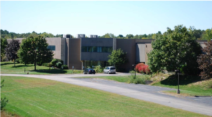
Property Record
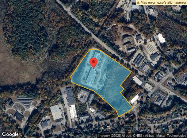
120 N Meadows Rd, Medfield, MA 02052

NEARBY LISTINGS FOR SALE OR LEASE
-
-
View all Medfield listings for lease on LoopNet.com
Property Detail
120 N Meadows Rd
MEDF-000048-000000-000001
Norfolk
Industrialgeneral
Massachusetts
X
1
25021C0154E
18.08 AC
2025
I-95 Corridor South
2025
Boston
406101
Boston-Cambridge-Newton, MA-NH
DEMOGRAPHICS near 120 N Meadows Rd
1 Mile
3 Mile
5 Mile
2024 Total Population
2,324
18,188
54,090
2029 Population
2,334
18,138
54,007
Pop Growth 2024-2029
+ 0.43%
(0.27%)
(0.15%)
Average Age
41
41
41
2024 Total Households
862
6,569
19,013
HH Growth 2024-2029
+ 0.35%
(0.29%)
(0.15%)
Median Household Inc
$141,517
$161,750
$172,928
Avg Household Size
2.70
2.70
2.80
2024 Avg HH Vehicles
2.00
2.00
2.00
Median Home Value
$722,850
$731,725
$728,099
Median Year Built
1968
1972
1973
Nearby Places
- Restaurants
- Banks
- Shops
- Fitness
- Groceries
PUBLIC TRANSPORTATION
COMMUTER RAIL
Walpole (Foxboro Line (Special Events Only) - Massachusetts Bay Transportation Authority Commuter Rail (Purple Line), Franklin Line - Massachusetts Bay Transportation Authority Commuter Rail (Purple Line))
DRIVE
WALK
Distance
Walpole (Foxboro Line (Special Events Only) - Massachusetts Bay Transportation Authority Commuter Rail (Purple Line), Franklin Line - Massachusetts Bay Transportation Authority Commuter Rail (Purple Line))
11 min
5.6 mi
Norfolk (Franklin Line - Massachusetts Bay Transportation Authority Commuter Rail (Purple Line))
DRIVE
WALK
Distance
Norfolk (Franklin Line - Massachusetts Bay Transportation Authority Commuter Rail (Purple Line))
13 min
6.7 mi
AIRPORT
General Edward Lawrence Logan International
DRIVE
WALK
Distance
General Edward Lawrence Logan International
48 min
25.1 mi
Worcester Regional
DRIVE
WALK
Distance
Worcester Regional
63 min
35.0 mi
Freight Ports
Port of Boston
DRIVE
WALK
Distance
Port of Boston
46 min
23.5 mi
SALE & LEASE HISTORY
LISTING DATE
SALE/LEASE

Sep 25, 2016
For Lease
Mar 21, 2023
For Lease
Jul 11, 2017
For Lease
Feb 21, 2017
For Lease
Aug 20, 2018
For Lease
Nearby Properties
Address
Land Use
TOTAL SIZE
Lot Size
Zoning
Address
Land Use
TOTAL SIZE
Lot Size
Zoning
61.50 AC
RS
Address
Land Use
TOTAL SIZE
Lot Size
Zoning
146,536 SF
3.30 AC
Address
Land Use
TOTAL SIZE
Lot Size
Zoning
36.60 AC
R2
Address
Land Use
TOTAL SIZE
Lot Size
Zoning
138,644 SF
12.89 AC
Address
Land Use
TOTAL SIZE
Lot Size
Zoning
16.98 AC
RS
Address
Land Use
TOTAL SIZE
Lot Size
Zoning
12.65 AC
B
Address
Land Use
TOTAL SIZE
Lot Size
Zoning
87.30 AC
A
Address
Land Use
TOTAL SIZE
Lot Size
Zoning
28,080 SF
2.80 AC
RU
Address
Land Use
TOTAL SIZE
Lot Size
Zoning
89,572 SF
4.50 AC
RS
Address
Land Use
TOTAL SIZE
Lot Size
Zoning
91,891 SF
10.03 AC
B
Address
Land Use
TOTAL SIZE
Lot Size
Zoning
157.50 AC
Address
Land Use
TOTAL SIZE
Lot Size
Zoning
65,190 SF
44.25 AC
RE
Address
Land Use
TOTAL SIZE
Lot Size
Zoning
12,960 SF
3.89 AC
RS
Address
Land Use
TOTAL SIZE
Lot Size
Zoning
14.91 AC
RU
Address
Land Use
TOTAL SIZE
Lot Size
Zoning
83,772 SF
7.69 AC
Address
Land Use
TOTAL SIZE
Lot Size
Zoning
117,230 SF
12.08 AC
IE
Address
Land Use
TOTAL SIZE
Lot Size
Zoning
80,860 SF
8.77 AC
Address
Land Use
TOTAL SIZE
Lot Size
Zoning
59.96 AC
R2
Address
Land Use
TOTAL SIZE
Lot Size
Zoning
4,480 SF
21.61 AC
RE
Address
Land Use
TOTAL SIZE
Lot Size
Zoning
71,001 SF
9.33 AC
Address
Land Use
TOTAL SIZE
Lot Size
Zoning
186.89 AC
RT
Address
Land Use
TOTAL SIZE
Lot Size
Zoning
24.42 AC
R2
Address
Land Use
TOTAL SIZE
Lot Size
Zoning
2,108 SF
3.20 AC
Address
Land Use
TOTAL SIZE
Lot Size
Zoning
182.58 AC
RT
Address
Land Use
TOTAL SIZE
Lot Size
Zoning
67.42 AC
R2
Address
Land Use
TOTAL SIZE
Lot Size
Zoning
28,342 SF
3.18 AC
B
Address
Land Use
TOTAL SIZE
Lot Size
Zoning
6.78 AC
RU
Address
Land Use
TOTAL SIZE
Lot Size
Zoning
34,867 SF
3.10 AC
Address
Land Use
TOTAL SIZE
Lot Size
Zoning
1.35 AC
RS
Address
Land Use
TOTAL SIZE
Lot Size
Zoning
0.94 AC
B
The World's #1 Commercial Real Estate Marketplace
Connect with us
© 2025 CoStar Group
The information above has been obtained from sources believed reliable. While we do not doubt its accuracy we have not verified it and make no guarantee, warranty or representation about it. It is your responsibility to independently confirm its accuracy and completeness. Any projections, opinions, assumptions, or estimates used are for example only and do not represent the current or future performance of the property. The value of this transaction to you depends on tax and other factors which should be evaluated by your tax, financial, and legal advisors. You and your advisors should conduct a careful, independent investigation of the property to determine to your satisfaction the suitability of the property for your needs.