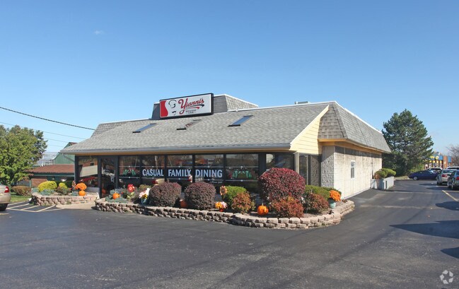
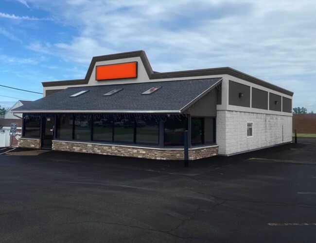
Property Record
120 Pixley Rd, Rochester, NY 14624

NEARBY LISTINGS FOR SALE OR LEASE
Property Detail
120 Pixley Rd
262600-119-090-0001-035-000
0162- 1-02 20000 AC
Restaurantbuilding
Monroe
X
New York
36055C0189G
35.000
2025
0.57 AC
2024
Southwest
014400
Rochester
3,670 SF
Rochester, NY
DEMOGRAPHICS near 120 Pixley Rd
1 Mile
3 Mile
5 Mile
2024 Total Population
4,484
50,584
171,111
2029 Population
4,407
49,792
168,391
Pop Growth 2024-2029
(1.72%)
(1.57%)
(1.59%)
Average Age
45
42
38
2024 Total Households
1,875
21,535
68,479
HH Growth 2024-2029
(1.87%)
(1.70%)
(1.68%)
Median Household Inc
$71,310
$69,091
$54,190
Avg Household Size
2.30
2.30
2.30
2024 Avg HH Vehicles
2.00
2.00
1.00
Median Home Value
$150,630
$146,461
$141,289
Median Year Built
1969
1966
1960
Nearby Places
Map Layers
Map Styles
 Street
 Aerial
- Restaurants
- Banks
- Shops
- Fitness
- Groceries
PUBLIC TRANSPORTATION
COMMUTER RAIL
DRIVE
WALK
Distance
12 min
5.9 mi
AIRPORT
Frederick Douglass/Greater Rochester International
DRIVE
WALK
Distance
Frederick Douglass/Greater Rochester International
11 min
5.7 mi
SALE & LEASE HISTORY
LISTING DATE
SALE/LEASE

Aug 06, 2024
For Lease
Nearby Properties
Address
Land Use
TOTAL SIZE
Lot Size
Zoning
Address
Land Use
TOTAL SIZE
Lot Size
Zoning
796,051 SF
100.85 AC
06 - INDUS
Address
Land Use
TOTAL SIZE
Lot Size
Zoning
Address
Land Use
TOTAL SIZE
Lot Size
Zoning
Address
Land Use
TOTAL SIZE
Lot Size
Zoning
628,572 SF
134.14 AC
06 - INDUS
Address
Land Use
TOTAL SIZE
Lot Size
Zoning
200,000 SF
764.91 AC
Address
Land Use
TOTAL SIZE
Lot Size
Zoning
348,895 SF
76.07 AC
06 - INDUS
Address
Land Use
TOTAL SIZE
Lot Size
Zoning
11,408 SF
98.28 AC
02 - SINGL
Address
Land Use
TOTAL SIZE
Lot Size
Zoning
540,000 SF
39.70 AC
06 - INDUS
Address
Land Use
TOTAL SIZE
Lot Size
Zoning
1,440 SF
5.40 AC
02 - SINGL
Address
Land Use
TOTAL SIZE
Lot Size
Zoning
671,599 SF
33.10 AC
06 - INDUS
Address
Land Use
TOTAL SIZE
Lot Size
Zoning
109,772 SF
10.42 AC
06 - INDUS
Address
Land Use
TOTAL SIZE
Lot Size
Zoning
201,774 SF
17.17 AC
05 - COMME
Address
Land Use
TOTAL SIZE
Lot Size
Zoning
119,777 SF
14.38 AC
06 - INDUS
Address
Land Use
TOTAL SIZE
Lot Size
Zoning
391,478 SF
29.27 AC
Address
Land Use
TOTAL SIZE
Lot Size
Zoning
250,500 SF
18 AC
Address
Land Use
TOTAL SIZE
Lot Size
Zoning
119,983 SF
17.80 AC
03 - MULTI
Address
Land Use
TOTAL SIZE
Lot Size
Zoning
14,268 SF
36.20 AC
MFR
Address
Land Use
TOTAL SIZE
Lot Size
Zoning
149,541 SF
6.10 AC
03 - MULTI
Address
Land Use
TOTAL SIZE
Lot Size
Zoning
8.86 AC
Address
Land Use
TOTAL SIZE
Lot Size
Zoning
67,000 SF
3.86 AC
Address
Land Use
TOTAL SIZE
Lot Size
Zoning
206,603 SF
13.35 AC
Address
Land Use
TOTAL SIZE
Lot Size
Zoning
190,815 SF
14.75 AC
Address
Land Use
TOTAL SIZE
Lot Size
Zoning
6,960 SF
20.31 AC
02 - SINGL
Address
Land Use
TOTAL SIZE
Lot Size
Zoning
52,400 SF
114.60 AC
Address
Land Use
TOTAL SIZE
Lot Size
Zoning
119,706 SF
16.43 AC
05 - COMME
Address
Land Use
TOTAL SIZE
Lot Size
Zoning
290 AC
06 - INDUS
Address
Land Use
TOTAL SIZE
Lot Size
Zoning
23,940 SF
6.45 AC
05 - COMME
Address
Land Use
TOTAL SIZE
Lot Size
Zoning
94,806 SF
23.30 AC
Address
Land Use
TOTAL SIZE
Lot Size
Zoning
9,556 SF
21.24 AC
MFR
Address
Land Use
TOTAL SIZE
Lot Size
Zoning
4,448 SF
18.78 AC
05 - COMME
The World's #1 Commercial Real Estate Marketplace
Connect with us
© 2026 CoStar Group
The information above has been obtained from sources believed reliable. While we do not doubt its accuracy we have not verified it and make no guarantee, warranty or representation about it. It is your responsibility to independently confirm its accuracy and completeness. Any projections, opinions, assumptions, or estimates used are for example only and do not represent the current or future performance of the property. The value of this transaction to you depends on tax and other factors which should be evaluated by your tax, financial, and legal advisors. You and your advisors should conduct a careful, independent investigation of the property to determine to your satisfaction the suitability of the property for your needs.