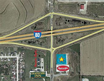
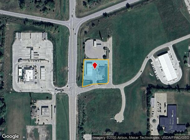
Property Record
1203 Guthrie St, De Soto, IA 50069
NEARBY LISTINGS FOR SALE OR LEASE
-
-
View all De Soto listings for sale on LoopNet.com
Property Detail
1203 Guthrie St
Des Moines-West Des Moines, IA
Ashland Crossroads Plat 1
15-19-301-017
ASHLAND CROSSROADS PLAT 1 LOT 1 /EX PARCEL A/
Storebuilding
Dallas
X
Iowa
19049C0320F
1
2023
1.25 AC
2023
Outlying Dallas County
050902
Des Moines
3,358 SF
DEMOGRAPHICS near 1203 Guthrie St
1 Mile
3 Mile
5 Mile
2024 Total Population
1,049
2,674
8,289
2029 Population
1,252
3,207
9,994
Pop Growth 2024-2029
+ 19.35%
+ 19.93%
+ 20.57%
Average Age
39
38
37
2024 Total Households
401
976
2,995
HH Growth 2024-2029
+ 20.20%
+ 20.70%
+ 21.40%
Median Household Inc
$75,325
$90,801
$93,802
Avg Household Size
2.60
2.70
2.80
2024 Avg HH Vehicles
3.00
3.00
3.00
Median Home Value
$177,868
$226,591
$263,659
Median Year Built
1975
1978
1993
Nearby Places
- Restaurants
- Banks
- Shops
- Fitness
- Groceries
PUBLIC TRANSPORTATION
AIRPORT
Des Moines International
Drive
Walk
Distance
Des Moines International
32 min
22.7 mi
Freight Ports
Port Milwaukee
Drive
Walk
Distance
Port Milwaukee
439 min
394.5 mi
Nearby Properties
Address
Land Use
TOTAL SIZE
Lot Size
Zoning
Address
Land Use
TOTAL SIZE
Lot Size
Zoning
8612
10 AC
Address
Land Use
TOTAL SIZE
Lot Size
Zoning
9000
59.47 AC
Address
Land Use
TOTAL SIZE
Lot Size
Zoning
12322
3 AC
Address
Land Use
TOTAL SIZE
Lot Size
Zoning
14500
9.78 AC
Address
Land Use
TOTAL SIZE
Lot Size
Zoning
18750
2.93 AC
Address
Land Use
TOTAL SIZE
Lot Size
Zoning
5376
4.24 AC
Address
Land Use
TOTAL SIZE
Lot Size
Zoning
1536
2.92 AC
Address
Land Use
TOTAL SIZE
Lot Size
Zoning
4119
1.15 AC
Address
Land Use
TOTAL SIZE
Lot Size
Zoning
9659
1.03 AC
Address
Land Use
TOTAL SIZE
Lot Size
Zoning
2400
1.85 AC
Address
Land Use
TOTAL SIZE
Lot Size
Zoning
3250
1.82 AC
Address
Land Use
TOTAL SIZE
Lot Size
Zoning
Address
Land Use
TOTAL SIZE
Lot Size
Zoning
10500
2.22 AC
Address
Land Use
TOTAL SIZE
Lot Size
Zoning
8000
1.89 AC
Address
Land Use
TOTAL SIZE
Lot Size
Zoning
6752
7.57 AC
Address
Land Use
TOTAL SIZE
Lot Size
Zoning
9600
1.40 AC
Address
Land Use
TOTAL SIZE
Lot Size
Zoning
9825
0.86 AC
Address
Land Use
TOTAL SIZE
Lot Size
Zoning
8000
1.50 AC
Address
Land Use
TOTAL SIZE
Lot Size
Zoning
3132
15.26 AC
Address
Land Use
TOTAL SIZE
Lot Size
Zoning
5500
1 AC
Address
Land Use
TOTAL SIZE
Lot Size
Zoning
1549
1.12 AC
Address
Land Use
TOTAL SIZE
Lot Size
Zoning
7800
0.50 AC
Address
Land Use
TOTAL SIZE
Lot Size
Zoning
9000
2.07 AC
Address
Land Use
TOTAL SIZE
Lot Size
Zoning
2562
0.33 AC
Address
Land Use
TOTAL SIZE
Lot Size
Zoning
4192
1.26 AC
Address
Land Use
TOTAL SIZE
Lot Size
Zoning
7760
0.57 AC
Address
Land Use
TOTAL SIZE
Lot Size
Zoning
4800
0.50 AC
Address
Land Use
TOTAL SIZE
Lot Size
Zoning
3600
1 AC
Start a new search to find other properties for sale or lease
Connect with us
© 2024 CoStar Group
The information above has been obtained from sources believed reliable. While we do not doubt its accuracy we have not verified it and make no guarantee, warranty or representation about it. It is your responsibility to independently confirm its accuracy and completeness. Any projections, opinions, assumptions, or estimates used are for example only and do not represent the current or future performance of the property. The value of this transaction to you depends on tax and other factors which should be evaluated by your tax, financial, and legal advisors. You and your advisors should conduct a careful, independent investigation of the property to determine to your satisfaction the suitability of the property for your needs.