Property Record
1209 Shelby Hwy, Cherryville, NC 28021
NEARBY LISTINGS FOR SALE OR LEASE
-
-
View all Cherryville listings for sale on LoopNet.com
Property Detail
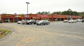
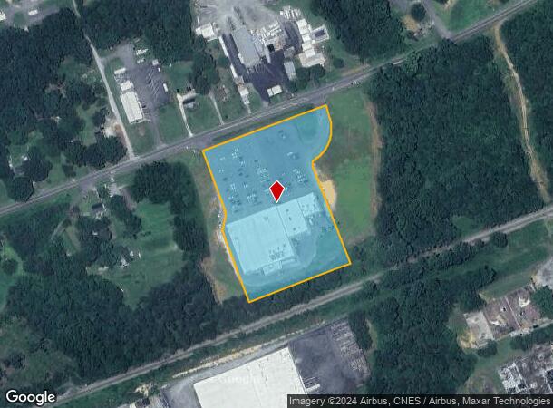
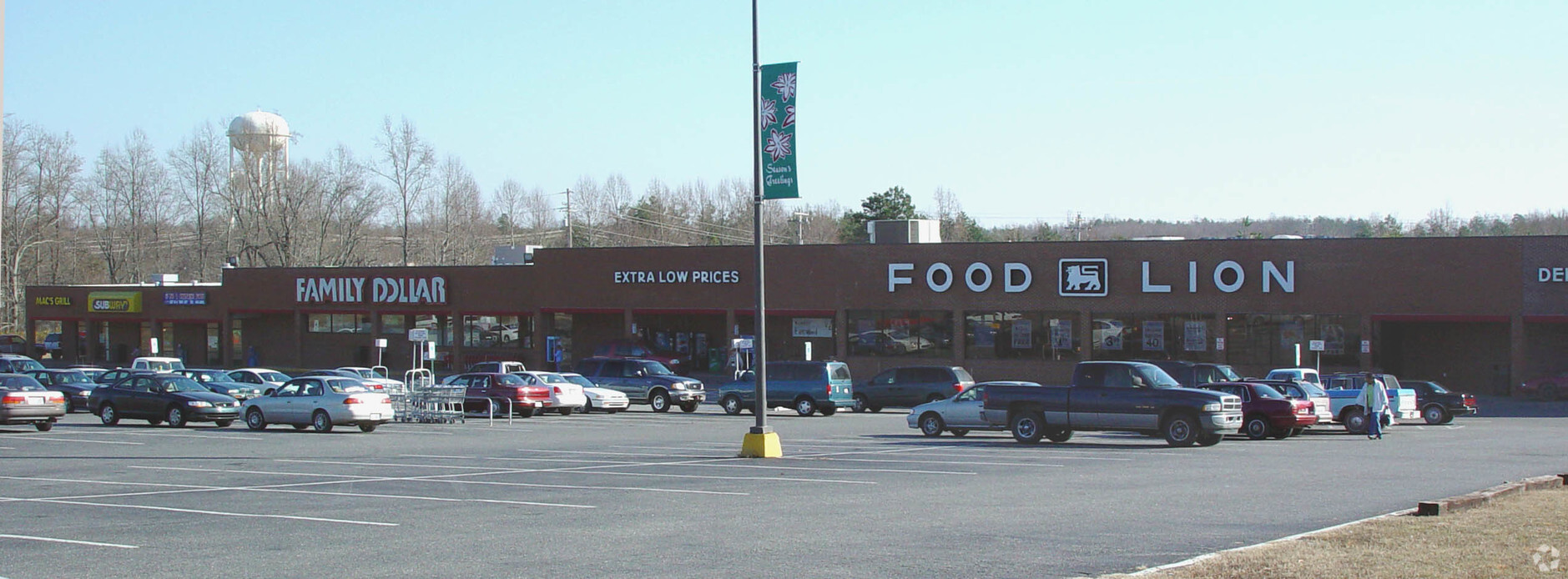
1209 Shelby Hwy
160330
CHERRYHILL CENTER L 2 12 052 006 00 000
Regionalshoppingcenterormallwithanchorstore
Gaston
X
North Carolina
3710268000J
4.99 AC
2024
Gaston County
2024
Charlotte
0306021024
Charlotte-Concord-Gastonia, NC-SC
45,862 SF
DEMOGRAPHICS near 1209 Shelby Hwy
1 Mile
3 Mile
5 Mile
2024 Total Population
2,537
10,009
17,658
2029 Population
2,727
10,656
18,803
Pop Growth 2024-2029
+ 7.49%
+ 6.46%
+ 6.48%
Average Age
42
42
41
2024 Total Households
1,033
4,028
6,966
HH Growth 2024-2029
+ 7.65%
+ 6.68%
+ 6.66%
Median Household Inc
$52,650
$49,489
$50,507
Avg Household Size
2.40
2.40
2.40
2024 Avg HH Vehicles
2.00
2.00
2.00
Median Home Value
$193,541
$170,611
$171,495
Median Year Built
1967
1973
1979
Nearby Places
- Restaurants
- Banks
- Shops
- Fitness
- Groceries
PUBLIC TRANSPORTATION
AIRPORT
Charlotte/Douglas International
DRIVE
WALK
Distance
Charlotte/Douglas International
55 min
33.8 mi
Freight Ports
North Charleston Terminal
DRIVE
WALK
Distance
North Charleston Terminal
265 min
220.8 mi
Nearby Properties
Address
Land Use
TOTAL SIZE
Lot Size
Zoning
Address
Land Use
TOTAL SIZE
Lot Size
Zoning
69,747 SF
18.33 AC
R1
Address
Land Use
TOTAL SIZE
Lot Size
Zoning
120,500 SF
12.50 AC
ELDD I-G
Address
Land Use
TOTAL SIZE
Lot Size
Zoning
1,320 SF
72.60 AC
Address
Land Use
TOTAL SIZE
Lot Size
Zoning
92,928 SF
21.25 AC
PUB01
Address
Land Use
TOTAL SIZE
Lot Size
Zoning
38,904 SF
5.84 AC
HCAR4
Address
Land Use
TOTAL SIZE
Lot Size
Zoning
3,917 SF
3.43 AC
R2
Address
Land Use
TOTAL SIZE
Lot Size
Zoning
75,190 SF
10.70 AC
PUB01
Address
Land Use
TOTAL SIZE
Lot Size
Zoning
62,238 SF
17 AC
PUB01
Address
Land Use
TOTAL SIZE
Lot Size
Zoning
11,669 SF
1.80 AC
ELDD PD-MU
Address
Land Use
TOTAL SIZE
Lot Size
Zoning
6,480 SF
12.98 AC
PUB01
Address
Land Use
TOTAL SIZE
Lot Size
Zoning
41,067 SF
2.42 AC
CHUR2
Address
Land Use
TOTAL SIZE
Lot Size
Zoning
35,044 SF
5.88 AC
CHUR2
Address
Land Use
TOTAL SIZE
Lot Size
Zoning
38,154 SF
26.69 AC
CHUR2
Address
Land Use
TOTAL SIZE
Lot Size
Zoning
106,624 SF
8.38 AC
INDS1
Address
Land Use
TOTAL SIZE
Lot Size
Zoning
22,808 SF
2.67 AC
HCAR4
Address
Land Use
TOTAL SIZE
Lot Size
Zoning
6,975 SF
105.20 AC
R2
Address
Land Use
TOTAL SIZE
Lot Size
Zoning
650 SF
4.33 AC
INDS1
Address
Land Use
TOTAL SIZE
Lot Size
Zoning
7,702 SF
1.55 AC
OFF01
Address
Land Use
TOTAL SIZE
Lot Size
Zoning
768 SF
11.52 AC
APT01
Address
Land Use
TOTAL SIZE
Lot Size
Zoning
26,004 SF
12.35 AC
CHUR2
Address
Land Use
TOTAL SIZE
Lot Size
Zoning
119,424 SF
11.57 AC
INDS2
Address
Land Use
TOTAL SIZE
Lot Size
Zoning
13,881 SF
2.48 AC
GOV06
Address
Land Use
TOTAL SIZE
Lot Size
Zoning
1,430 SF
2.57 AC
APT01
Address
Land Use
TOTAL SIZE
Lot Size
Zoning
20,046 SF
17.69 AC
CHUR2
Address
Land Use
TOTAL SIZE
Lot Size
Zoning
3,712 SF
2.33 AC
APT01
Address
Land Use
TOTAL SIZE
Lot Size
Zoning
13,480 SF
4.88 AC
AA3
Address
Land Use
TOTAL SIZE
Lot Size
Zoning
512 SF
918.24 AC
R15
Address
Land Use
TOTAL SIZE
Lot Size
Zoning
3,811 SF
0.88 AC
REST1
Address
Land Use
TOTAL SIZE
Lot Size
Zoning
3,984 SF
111.08 AC
The World's #1 Commercial Real Estate Marketplace
Connect with us
© 2025 CoStar Group
The information above has been obtained from sources believed reliable. While we do not doubt its accuracy we have not verified it and make no guarantee, warranty or representation about it. It is your responsibility to independently confirm its accuracy and completeness. Any projections, opinions, assumptions, or estimates used are for example only and do not represent the current or future performance of the property. The value of this transaction to you depends on tax and other factors which should be evaluated by your tax, financial, and legal advisors. You and your advisors should conduct a careful, independent investigation of the property to determine to your satisfaction the suitability of the property for your needs.