Property Record
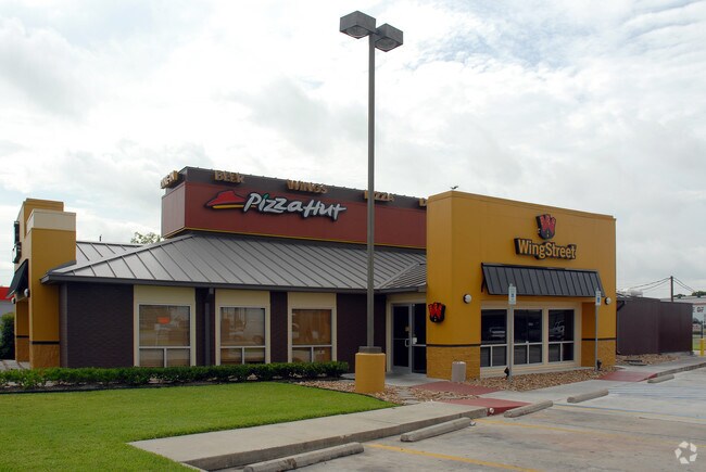
1211 W Main St, Tomball, TX 77375

NEARBY LISTINGS FOR SALE OR LEASE
Property Detail
1211 W Main St
0402700010742
Abst 34 J House
Restaurantdrivein
TR 25A-4 ABST 34 J HOUSE
X
Harris
48339C0675G
Texas
2024
0.65 AC
2025
Far Tomball
555404
Houston
3,326 SF
Houston-The Woodlands-Sugar Land, TX
DEMOGRAPHICS near 1211 W Main St
1 Mile
3 Mile
5 Mile
2024 Total Population
5,315
22,989
106,340
2029 Population
5,529
24,174
111,614
Pop Growth 2024-2029
+ 4.03%
+ 5.15%
+ 4.96%
Average Age
43
40
36
2024 Total Households
2,386
8,689
35,556
HH Growth 2024-2029
+ 4.19%
+ 5.14%
+ 5.03%
Median Household Inc
$44,374
$77,457
$95,944
Avg Household Size
2.10
2.60
2.90
2024 Avg HH Vehicles
1.00
2.00
2.00
Median Home Value
$250,218
$324,855
$292,486
Median Year Built
1986
1999
2007
Nearby Places
Map Layers
Map Styles
 Street
 Aerial
- Restaurants
- Banks
- Shops
- Fitness
- Groceries
PUBLIC TRANSPORTATION
AIRPORT
George Bush Intcntl/Houston
DRIVE
WALK
Distance
George Bush Intcntl/Houston
35 min
27.8 mi
Freight Ports
Port of Houston
DRIVE
WALK
Distance
Port of Houston
55 min
38.4 mi
SALE & LEASE HISTORY
LISTING DATE
SALE/LEASE

Mar 06, 2018
For Sale
Nearby Properties
Address
Land Use
TOTAL SIZE
Lot Size
Zoning
Address
Land Use
TOTAL SIZE
Lot Size
Zoning
722,325 SF
27.72 AC
Address
Land Use
TOTAL SIZE
Lot Size
Zoning
914,880 SF
50.50 AC
Address
Land Use
TOTAL SIZE
Lot Size
Zoning
749,700 SF
35.22 AC
Address
Land Use
TOTAL SIZE
Lot Size
Zoning
148,105 SF
19.73 AC
Address
Land Use
TOTAL SIZE
Lot Size
Zoning
451,840 SF
44.47 AC
Address
Land Use
TOTAL SIZE
Lot Size
Zoning
331,691 SF
17.95 AC
Address
Land Use
TOTAL SIZE
Lot Size
Zoning
123,937 SF
5.52 AC
Address
Land Use
TOTAL SIZE
Lot Size
Zoning
155,960 SF
25.96 AC
Address
Land Use
TOTAL SIZE
Lot Size
Zoning
179,083 SF
8.29 AC
Address
Land Use
TOTAL SIZE
Lot Size
Zoning
230,612 SF
28.42 AC
Address
Land Use
TOTAL SIZE
Lot Size
Zoning
142,427 SF
12.02 AC
Address
Land Use
TOTAL SIZE
Lot Size
Zoning
110,553 SF
10.34 AC
Address
Land Use
TOTAL SIZE
Lot Size
Zoning
87,936 SF
3.92 AC
Address
Land Use
TOTAL SIZE
Lot Size
Zoning
176,180 SF
7.28 AC
Address
Land Use
TOTAL SIZE
Lot Size
Zoning
77,804 SF
5.73 AC
Address
Land Use
TOTAL SIZE
Lot Size
Zoning
146,605 SF
12.99 AC
Address
Land Use
TOTAL SIZE
Lot Size
Zoning
146,990 SF
7.02 AC
Address
Land Use
TOTAL SIZE
Lot Size
Zoning
59,119 SF
6.26 AC
Address
Land Use
TOTAL SIZE
Lot Size
Zoning
153,224 SF
5.04 AC
Address
Land Use
TOTAL SIZE
Lot Size
Zoning
112,854 SF
5.80 AC
Address
Land Use
TOTAL SIZE
Lot Size
Zoning
118,004 SF
5.55 AC
Address
Land Use
TOTAL SIZE
Lot Size
Zoning
194,195 SF
Address
Land Use
TOTAL SIZE
Lot Size
Zoning
55,008 SF
4.76 AC
Address
Land Use
TOTAL SIZE
Lot Size
Zoning
65,564 SF
10.06 AC
Address
Land Use
TOTAL SIZE
Lot Size
Zoning
103,000 SF
8.36 AC
Address
Land Use
TOTAL SIZE
Lot Size
Zoning
88,950 SF
12.24 AC
Address
Land Use
TOTAL SIZE
Lot Size
Zoning
135,804 SF
15.33 AC
Address
Land Use
TOTAL SIZE
Lot Size
Zoning
285,837 SF
13.31 AC
Address
Land Use
TOTAL SIZE
Lot Size
Zoning
37,200 SF
2.22 AC
The World's #1 Commercial Real Estate Marketplace
Connect with us
© 2025 CoStar Group
The information above has been obtained from sources believed reliable. While we do not doubt its accuracy we have not verified it and make no guarantee, warranty or representation about it. It is your responsibility to independently confirm its accuracy and completeness. Any projections, opinions, assumptions, or estimates used are for example only and do not represent the current or future performance of the property. The value of this transaction to you depends on tax and other factors which should be evaluated by your tax, financial, and legal advisors. You and your advisors should conduct a careful, independent investigation of the property to determine to your satisfaction the suitability of the property for your needs.