Property Record
12130 S Vancouver Ave, Glenpool, OK 74033


NEARBY LISTINGS FOR SALE OR LEASE
Property Detail
12130 S Vancouver Ave
Tulsa, OK
Southwest Crossroads
85365-72-03-15375
PRT LT 1 BEG 200S NWC LT 1 TH E200 S39.58 W200 N39.58 POB & PRT LT 2 BEG 124.39N SWC LT 2 TH N105.42 E200 S84.08 CRV RT 21.34 W199.38 POB BLK 3
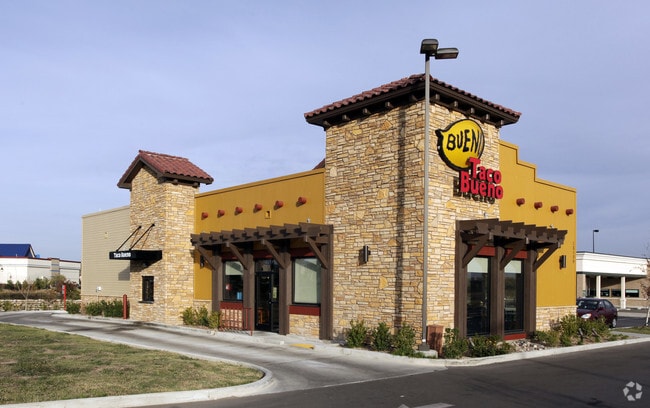
Restaurantbuilding
Tulsa
X
Oklahoma
40143C0407L
1
2025
0.67 AC
2025
South Tulsa
007707
Tulsa
2,714 SF
DEMOGRAPHICS near 12130 S Vancouver Ave
1 Mile
3 Mile
5 Mile
2024 Total Population
2,927
32,682
70,388
2029 Population
3,036
33,729
72,864
Pop Growth 2024-2029
+ 3.72%
+ 3.20%
+ 3.52%
Average Age
35
36
37
2024 Total Households
993
11,159
26,177
HH Growth 2024-2029
+ 3.73%
+ 3.28%
+ 3.44%
Median Household Inc
$80,482
$85,113
$75,690
Avg Household Size
2.90
2.90
2.70
2024 Avg HH Vehicles
2.00
2.00
2.00
Median Home Value
$280,904
$238,568
$245,748
Median Year Built
2010
2000
1997
Nearby Places
Map Layers
Map Styles
 Street
 Aerial
- Restaurants
- Banks
- Shops
- Fitness
- Groceries
PUBLIC TRANSPORTATION
AIRPORT
Tulsa International
DRIVE
WALK
Distance
Tulsa International
30 min
21.4 mi
Freight Ports
DRIVE
WALK
Distance
38 min
28.8 mi
SALE & LEASE HISTORY
LISTING DATE
SALE/LEASE

Nov 01, 2017
For Sale
Nearby Properties
Address
Land Use
TOTAL SIZE
Lot Size
Zoning
Address
Land Use
TOTAL SIZE
Lot Size
Zoning
49,344 SF
5.34 AC
CG
Address
Land Use
TOTAL SIZE
Lot Size
Zoning
52,441 SF
12.79 AC
CS
Address
Land Use
TOTAL SIZE
Lot Size
Zoning
58,907 SF
5 AC
CG
Address
Land Use
TOTAL SIZE
Lot Size
Zoning
358,394 SF
38.86 AC
Address
Land Use
TOTAL SIZE
Lot Size
Zoning
31,313 SF
17.95 AC
IL
Address
Land Use
TOTAL SIZE
Lot Size
Zoning
81,732 SF
26.20 AC
AG
Address
Land Use
TOTAL SIZE
Lot Size
Zoning
49,025 SF
10.75 AC
AG
Address
Land Use
TOTAL SIZE
Lot Size
Zoning
28,761 SF
9.71 AC
RS1
Address
Land Use
TOTAL SIZE
Lot Size
Zoning
87,304 SF
3.29 AC
CN
Address
Land Use
TOTAL SIZE
Lot Size
Zoning
137,364 SF
14.65 AC
RS3
Address
Land Use
TOTAL SIZE
Lot Size
Zoning
186,012 SF
9.31 AC
RS3
Address
Land Use
TOTAL SIZE
Lot Size
Zoning
331,125 SF
17.64 AC
CG
Address
Land Use
TOTAL SIZE
Lot Size
Zoning
25,555 SF
17.31 AC
CN
Address
Land Use
TOTAL SIZE
Lot Size
Zoning
15,636 SF
4.91 AC
AG
Address
Land Use
TOTAL SIZE
Lot Size
Zoning
250,717 SF
10.11 AC
CS
Address
Land Use
TOTAL SIZE
Lot Size
Zoning
11,436 SF
1.38 AC
CG
Address
Land Use
TOTAL SIZE
Lot Size
Zoning
9,521 SF
2.58 AC
OM
Address
Land Use
TOTAL SIZE
Lot Size
Zoning
26,708 SF
2.86 AC
CS
Address
Land Use
TOTAL SIZE
Lot Size
Zoning
25,932 SF
15 AC
RE
Address
Land Use
TOTAL SIZE
Lot Size
Zoning
216,308 SF
23.91 AC
CG
Address
Land Use
TOTAL SIZE
Lot Size
Zoning
23,600 SF
15.69 AC
Address
Land Use
TOTAL SIZE
Lot Size
Zoning
5,110 SF
25.09 AC
AG
Address
Land Use
TOTAL SIZE
Lot Size
Zoning
3,660 SF
10 AC
CG
Address
Land Use
TOTAL SIZE
Lot Size
Zoning
80,336 SF
7.77 AC
AG
Address
Land Use
TOTAL SIZE
Lot Size
Zoning
19,857 SF
3.44 AC
AG
Address
Land Use
TOTAL SIZE
Lot Size
Zoning
27.87 AC
IM
Address
Land Use
TOTAL SIZE
Lot Size
Zoning
16,068 SF
0.80 AC
CG
Address
Land Use
TOTAL SIZE
Lot Size
Zoning
32,408 SF
6.25 AC
AG
Address
Land Use
TOTAL SIZE
Lot Size
Zoning
11,745 SF
1.88 AC
AG
Address
Land Use
TOTAL SIZE
Lot Size
Zoning
12,938 SF
2.14 AC
CG
The World's #1 Commercial Real Estate Marketplace
Connect with us
© 2026 CoStar Group
The information above has been obtained from sources believed reliable. While we do not doubt its accuracy we have not verified it and make no guarantee, warranty or representation about it. It is your responsibility to independently confirm its accuracy and completeness. Any projections, opinions, assumptions, or estimates used are for example only and do not represent the current or future performance of the property. The value of this transaction to you depends on tax and other factors which should be evaluated by your tax, financial, and legal advisors. You and your advisors should conduct a careful, independent investigation of the property to determine to your satisfaction the suitability of the property for your needs.