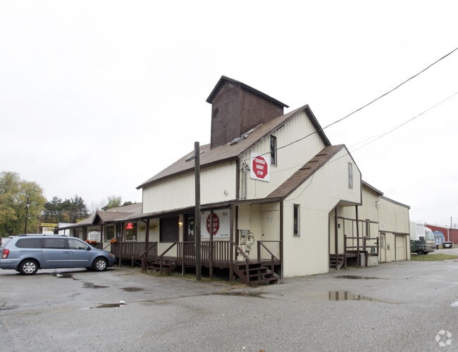
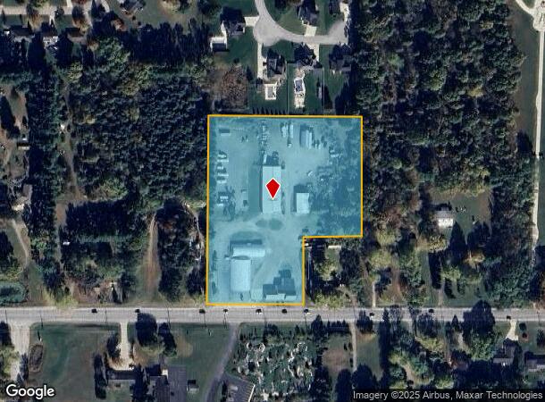
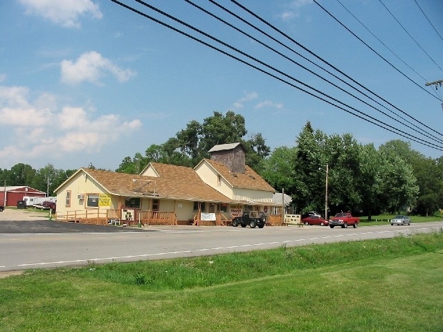
Property Record
12131 Adams Rd, Granger, IN 46530
NEARBY LISTINGS FOR SALE OR LEASE
Property Detail
12131 Adams Rd
South Bend-Mishawaka, IN-MI
Kendall Minor Subdivision
71-05-07-477-011.000-011
KENDALL MINOR SUBDIVISION LOT 1
Commercialnec
St Joseph
X
Indiana
18039C0015D
1
2023
6.12 AC
2024
Outlying St Joseph County
011406
South Bend/Mishawaka
26,342 SF
DEMOGRAPHICS near 12131 Adams Rd
1 Mile
3 Mile
5 Mile
2024 Total Population
2,807
17,685
48,902
2029 Population
2,742
17,455
48,258
Pop Growth 2024-2029
(2.32%)
(1.30%)
(1.32%)
Average Age
40
39
40
2024 Total Households
981
5,925
18,003
HH Growth 2024-2029
(2.45%)
(1.40%)
(1.34%)
Median Household Inc
$116,110
$112,608
$96,013
Avg Household Size
2.80
2.90
2.70
2024 Avg HH Vehicles
3.00
2.00
2.00
Median Home Value
$240,700
$265,807
$245,650
Median Year Built
1985
1990
1988
Nearby Places
Map Layers
Map Styles
 Street
 Aerial
- Restaurants
- Banks
- Shops
- Fitness
- Groceries
PUBLIC TRANSPORTATION
AIRPORT
South Bend International
DRIVE
WALK
Distance
South Bend International
35 min
19.4 mi
Freight Ports
Port Milwaukee
DRIVE
WALK
Distance
Port Milwaukee
225 min
187.0 mi
Nearby Properties
Address
Land Use
TOTAL SIZE
Lot Size
Zoning
Address
Land Use
TOTAL SIZE
Lot Size
Zoning
138,405 SF
87 SF
Address
Land Use
TOTAL SIZE
Lot Size
Zoning
70,532 SF
87 SF
Address
Land Use
TOTAL SIZE
Lot Size
Zoning
73,600 SF
44 SF
Address
Land Use
TOTAL SIZE
Lot Size
Zoning
35,063 SF
87 SF
Address
Land Use
TOTAL SIZE
Lot Size
Zoning
81,550 SF
44 SF
Address
Land Use
TOTAL SIZE
Lot Size
Zoning
0.02 AC
Address
Land Use
TOTAL SIZE
Lot Size
Zoning
30,292 SF
44 SF
Address
Land Use
TOTAL SIZE
Lot Size
Zoning
191,022 SF
9.60 AC
Address
Land Use
TOTAL SIZE
Lot Size
Zoning
12,230 SF
44 SF
Address
Land Use
TOTAL SIZE
Lot Size
Zoning
196,170 SF
87 SF
Address
Land Use
TOTAL SIZE
Lot Size
Zoning
161,884 SF
8.30 AC
Address
Land Use
TOTAL SIZE
Lot Size
Zoning
22,750 SF
1.47 AC
Address
Land Use
TOTAL SIZE
Lot Size
Zoning
12,484 SF
174 SF
Address
Land Use
TOTAL SIZE
Lot Size
Zoning
23,199 SF
7.07 AC
Address
Land Use
TOTAL SIZE
Lot Size
Zoning
87,056 SF
4.22 AC
Address
Land Use
TOTAL SIZE
Lot Size
Zoning
43,321 SF
9.22 AC
Address
Land Use
TOTAL SIZE
Lot Size
Zoning
17,114 SF
5.24 AC
Address
Land Use
TOTAL SIZE
Lot Size
Zoning
9,515 SF
174 SF
Address
Land Use
TOTAL SIZE
Lot Size
Zoning
31,110 SF
2.42 AC
ZO01
Address
Land Use
TOTAL SIZE
Lot Size
Zoning
88,328 SF
47.92 AC
Address
Land Use
TOTAL SIZE
Lot Size
Zoning
15,276 SF
1.59 AC
Address
Land Use
TOTAL SIZE
Lot Size
Zoning
393,455 SF
174 SF
Address
Land Use
TOTAL SIZE
Lot Size
Zoning
10,456 SF
2.01 AC
Address
Land Use
TOTAL SIZE
Lot Size
Zoning
14,796 SF
2.34 AC
Address
Land Use
TOTAL SIZE
Lot Size
Zoning
9,796 SF
1.43 AC
Address
Land Use
TOTAL SIZE
Lot Size
Zoning
12,600 SF
2.78 AC
Address
Land Use
TOTAL SIZE
Lot Size
Zoning
14,859 SF
2.11 AC
Address
Land Use
TOTAL SIZE
Lot Size
Zoning
18,882 SF
2.15 AC
Address
Land Use
TOTAL SIZE
Lot Size
Zoning
4,508 SF
2.91 AC
Address
Land Use
TOTAL SIZE
Lot Size
Zoning
7,864 SF
44 SF
The World's #1 Commercial Real Estate Marketplace
Connect with us
© 2026 CoStar Group
The information above has been obtained from sources believed reliable. While we do not doubt its accuracy we have not verified it and make no guarantee, warranty or representation about it. It is your responsibility to independently confirm its accuracy and completeness. Any projections, opinions, assumptions, or estimates used are for example only and do not represent the current or future performance of the property. The value of this transaction to you depends on tax and other factors which should be evaluated by your tax, financial, and legal advisors. You and your advisors should conduct a careful, independent investigation of the property to determine to your satisfaction the suitability of the property for your needs.