Property Record
1215 E Shelby Dr, Memphis, TN 38116


NEARBY LISTINGS FOR SALE OR LEASE
Property Detail
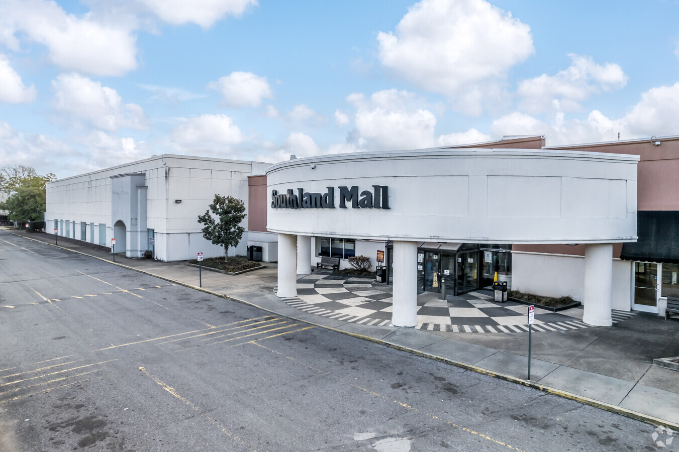
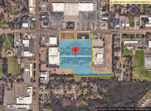
1215 E Shelby Dr
07-9061-0-0200
Goldsmiths Sc-1 Reg Shop Ctr
Regionalshoppingcenterormallwithanchorstore
SS SHELBY DR SEE MAP GRID 212 H
X
Shelby
05035C0475E
Tennessee
2023
19.11 AC
2024
South
022121
Memphis
290,513 SF
Memphis, TN-MS-AR
DEMOGRAPHICS near 1215 E Shelby Dr
1 Mile
3 Mile
5 Mile
2024 Total Population
8,217
63,321
136,905
2029 Population
8,079
63,698
140,228
Pop Growth 2024-2029
(1.68%)
+ 0.60%
+ 2.43%
Average Age
41
38
38
2024 Total Households
3,154
24,090
52,072
HH Growth 2024-2029
(1.87%)
+ 0.52%
+ 2.38%
Median Household Inc
$45,871
$41,286
$42,059
Avg Household Size
2.50
2.60
2.60
2024 Avg HH Vehicles
2.00
2.00
2.00
Median Home Value
$144,146
$98,779
$100,078
Median Year Built
1965
1965
1970
Nearby Places
- Restaurants
- Banks
- Shops
- Fitness
- Groceries
PUBLIC TRANSPORTATION
AIRPORT
Memphis International
DRIVE
WALK
Distance
Memphis International
9 min
5.2 mi
Freight Ports
Port of Shreveport
DRIVE
WALK
Distance
Port of Shreveport
411 min
377.8 mi
SALE & LEASE HISTORY
LISTING DATE
SALE/LEASE

Sep 11, 2018
For Sale
Oct 04, 2016
For Lease
May 04, 2020
For Lease
Nearby Properties
Address
Land Use
TOTAL SIZE
Lot Size
Zoning
Address
Land Use
TOTAL SIZE
Lot Size
Zoning
732,894 SF
79.73 AC
WD
Address
Land Use
TOTAL SIZE
Lot Size
Zoning
279,419 SF
172.07 AC
EMP
Address
Land Use
TOTAL SIZE
Lot Size
Zoning
146,316 SF
18.07 AC
CMU-3
Address
Land Use
TOTAL SIZE
Lot Size
Zoning
1,009,363 SF
78.56 AC
EMP
Address
Land Use
TOTAL SIZE
Lot Size
Zoning
1,013,319 SF
38.86 AC
EMP
Address
Land Use
TOTAL SIZE
Lot Size
Zoning
180,831 SF
13.11 AC
EMP
Address
Land Use
TOTAL SIZE
Lot Size
Zoning
357,582 SF
5.61 AC
EMP
Address
Land Use
TOTAL SIZE
Lot Size
Zoning
853,440 SF
39.22 AC
EMP
Address
Land Use
TOTAL SIZE
Lot Size
Zoning
47.65 AC
R-8
Address
Land Use
TOTAL SIZE
Lot Size
Zoning
214,950 SF
17.05 AC
CMU-2
Address
Land Use
TOTAL SIZE
Lot Size
Zoning
38,600 SF
30.35 AC
RU-3
Address
Land Use
TOTAL SIZE
Lot Size
Zoning
61,164 SF
36.95 AC
RU-3
Address
Land Use
TOTAL SIZE
Lot Size
Zoning
14,075 SF
9.36 AC
RU-3
Address
Land Use
TOTAL SIZE
Lot Size
Zoning
144,078 SF
17.93 AC
RU-3
Address
Land Use
TOTAL SIZE
Lot Size
Zoning
432,700 SF
28.16 AC
EMP
Address
Land Use
TOTAL SIZE
Lot Size
Zoning
52,347 SF
11.55 AC
R-8
Address
Land Use
TOTAL SIZE
Lot Size
Zoning
165,227 SF
25.12 AC
RU-3
Address
Land Use
TOTAL SIZE
Lot Size
Zoning
81,790 SF
17.82 AC
CMU-2
Address
Land Use
TOTAL SIZE
Lot Size
Zoning
188,404 SF
59.17 AC
R-8
Address
Land Use
TOTAL SIZE
Lot Size
Zoning
230,103 SF
22.07 AC
CMU-2
Address
Land Use
TOTAL SIZE
Lot Size
Zoning
321.59 AC
R-8
Address
Land Use
TOTAL SIZE
Lot Size
Zoning
318,661 SF
26.92 AC
CMU-3
Address
Land Use
TOTAL SIZE
Lot Size
Zoning
779,780 SF
46.22 AC
PBP
Address
Land Use
TOTAL SIZE
Lot Size
Zoning
79,658 SF
7 AC
RU-3
Address
Land Use
TOTAL SIZE
Lot Size
Zoning
79,340 SF
7 AC
RU-3
Address
Land Use
TOTAL SIZE
Lot Size
Zoning
43,476 SF
4.62 AC
CMU-3
Address
Land Use
TOTAL SIZE
Lot Size
Zoning
80,264 SF
10.14 AC
RU-3
Address
Land Use
TOTAL SIZE
Lot Size
Zoning
111,541 SF
8.88 AC
R-8
Address
Land Use
TOTAL SIZE
Lot Size
Zoning
147,890 SF
16.92 AC
EMP
Address
Land Use
TOTAL SIZE
Lot Size
Zoning
34.26 AC
R-6
The World's #1 Commercial Real Estate Marketplace
Connect with us
© 2025 CoStar Group
The information above has been obtained from sources believed reliable. While we do not doubt its accuracy we have not verified it and make no guarantee, warranty or representation about it. It is your responsibility to independently confirm its accuracy and completeness. Any projections, opinions, assumptions, or estimates used are for example only and do not represent the current or future performance of the property. The value of this transaction to you depends on tax and other factors which should be evaluated by your tax, financial, and legal advisors. You and your advisors should conduct a careful, independent investigation of the property to determine to your satisfaction the suitability of the property for your needs.