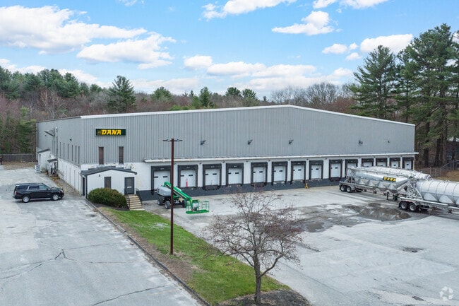
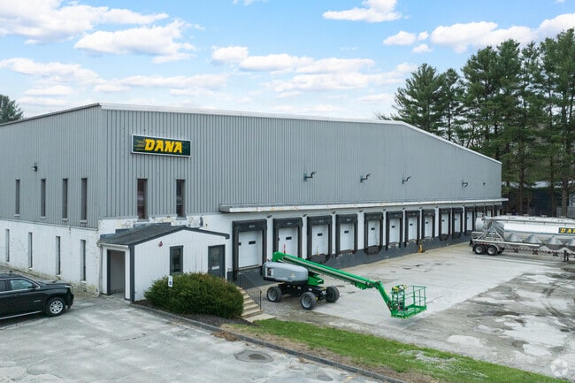
Property Record
122 Main St, Oxford, MA 01540

Property Detail
122 Main St
Warehouse
WORCESTER
GB
Massachusetts
B and X Area of moderate flood hazard, usually the area between the limits of the 100-year and 500-year floods.
4.54 AC
2025
Outlying Worcester
2025
Boston
753200
Worcester, MA
42,139 SF
OXFO-000050B-000000-C002201
NEARBY LISTINGS FOR SALE OR LEASE
DEMOGRAPHICS near 122 Main St
1 mile
3 mile
5 mile
2025 Total Population
3,005
17,033
43,615
2030 Population
3,072
17,399
44,597
Pop Growth 2025-2030
+ 2.23%
+ 2.15%
+ 2.25%
Average Age
43
43
43
2025 Total Households
1,151
6,862
17,721
HH Growth 2025-2030
+ 2.35%
+ 2.20%
+ 2.31%
Median Household Inc
$99,387
$89,370
$87,291
Avg Household Size
2.50
2.40
2.40
2025 Avg HH Vehicles
2.00
2.00
2.00
Median Home Value
$352,783
$370,115
$388,617
Median Year Built
1967
1966
1967
Nearby Places
Map Layers
Map Styles
 Street
 Aerial
Layers
 Traffic
 Biking
Places
Listings with unknown addresses are not visible on the map
- Restaurants
- Banks
- Shops
- Fitness
- Groceries
PUBLIC TRANSPORTATION
AIRPORT
Worcester Regional
Drive
Walk
Distance
Worcester Regional
28 min
15.6 mi
Rhode Island Tf Green International
Drive
Walk
Distance
Rhode Island Tf Green International
67 min
47.8 mi
Freight Ports
Port of Boston
Drive
Walk
Distance
Port of Boston
74 min
54.7 mi
SALE & LEASE HISTORY
LISTING DATE
SALE/LEASE

Oct 10, 2018
For Lease
Nearby Properties
Address
Land Use
TOTAL SIZE
Lot Size
Zoning
Address
Land Use
TOTAL SIZE
Lot Size
Zoning
95,274 SF
10.18 AC
Address
Land Use
TOTAL SIZE
Lot Size
Zoning
34 AC
LI
Address
Land Use
TOTAL SIZE
Lot Size
Zoning
15.60 AC
R2
Address
Land Use
TOTAL SIZE
Lot Size
Zoning
9.05 AC
INDUST
Address
Land Use
TOTAL SIZE
Lot Size
Zoning
131,686 SF
14.60 AC
INDUST
Address
Land Use
TOTAL SIZE
Lot Size
Zoning
13.22 AC
INDUST
Address
Land Use
TOTAL SIZE
Lot Size
Zoning
175,000 SF
10.01 AC
LI
Address
Land Use
TOTAL SIZE
Lot Size
Zoning
4.87 AC
INDUST
Address
Land Use
TOTAL SIZE
Lot Size
Zoning
199,444 SF
179.03 AC
R1
Address
Land Use
TOTAL SIZE
Lot Size
Zoning
105,657 SF
12.65 AC
HI
Address
Land Use
TOTAL SIZE
Lot Size
Zoning
20.31 AC
INDUST
Address
Land Use
TOTAL SIZE
Lot Size
Zoning
81,491 SF
6.64 AC
HI
Address
Land Use
TOTAL SIZE
Lot Size
Zoning
10.09 AC
Address
Land Use
TOTAL SIZE
Lot Size
Zoning
109,380 SF
27.60 AC
R2
Address
Land Use
TOTAL SIZE
Lot Size
Zoning
102,704 SF
31 AC
GB-4 W
Address
Land Use
TOTAL SIZE
Lot Size
Zoning
164,660 SF
15.40 AC
INDUST
Address
Land Use
TOTAL SIZE
Lot Size
Zoning
123,910 SF
10 AC
INDUST
Address
Land Use
TOTAL SIZE
Lot Size
Zoning
60 AC
INDUST
Address
Land Use
TOTAL SIZE
Lot Size
Zoning
52,677 SF
15.17 AC
Address
Land Use
TOTAL SIZE
Lot Size
Zoning
45,054 SF
6.60 AC
HI
Address
Land Use
TOTAL SIZE
Lot Size
Zoning
3,600 SF
9.52 AC
GB
Address
Land Use
TOTAL SIZE
Lot Size
Zoning
51,609 SF
10.24 AC
R3
Address
Land Use
TOTAL SIZE
Lot Size
Zoning
8.96 AC
GB-5 W
Address
Land Use
TOTAL SIZE
Lot Size
Zoning
54,273 SF
8.94 AC
INDUST
Address
Land Use
TOTAL SIZE
Lot Size
Zoning
9,496 SF
13.25 AC
R3
Address
Land Use
TOTAL SIZE
Lot Size
Zoning
5.24 AC
GB-4 W
Address
Land Use
TOTAL SIZE
Lot Size
Zoning
6.08 AC
MR-12,
Address
Land Use
TOTAL SIZE
Lot Size
Zoning
4.60 AC
I
Address
Land Use
TOTAL SIZE
Lot Size
Zoning
10 AC
LI
Address
Land Use
TOTAL SIZE
Lot Size
Zoning
60,233 SF
4.09 AC
GB-4 W
The World's #1 Commercial Real Estate Marketplace
Connect with us
© 2026 CoStar Group
The information above has been obtained from sources believed reliable. While we do not doubt its accuracy we have not verified it and make no guarantee, warranty or representation about it. It is your responsibility to independently confirm its accuracy and completeness. Any projections, opinions, assumptions, or estimates used are for example only and do not represent the current or future performance of the property. The value of this transaction to you depends on tax and other factors which should be evaluated by your tax, financial, and legal advisors. You and your advisors should conduct a careful, independent investigation of the property to determine to your satisfaction the suitability of the property for your needs.