Property Record
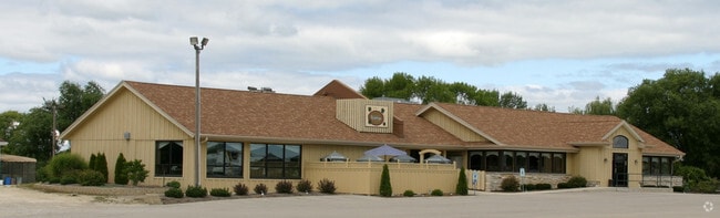
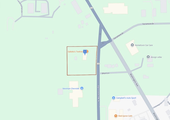
1221 Wauwatosa Rd, Cedarburg, WI 53012

NEARBY LISTINGS FOR SALE OR LEASE
Property Detail
1221 Wauwatosa Rd
Milwaukee-Waukesha-West Allis, WI
1504/784 PART NE NE 2.510 ACS COMM 33 FT W OF SE COR TH W 367 FT N 361 FT E 400 FT SE 230 FT S 132 FT POB BEING PART #408 CSM LOT 1 VOL 2/129 SEC 21 T 10R 21
30210102100
Ozaukee
Commercialnec
Wisconsin
AE
1
55089C0159G
2.51 AC
2024
North Ozaukee
2024
Milwaukee/Madison
650300
DEMOGRAPHICS near 1221 Wauwatosa Rd
1 Mile
3 Mile
5 Mile
2024 Total Population
1,862
23,810
37,382
2029 Population
1,880
24,381
38,583
Pop Growth 2024-2029
+ 0.97%
+ 2.40%
+ 3.21%
Average Age
44
43
43
2024 Total Households
764
9,925
15,118
HH Growth 2024-2029
+ 0.92%
+ 2.31%
+ 3.10%
Median Household Inc
$78,885
$80,091
$86,640
Avg Household Size
2.40
2.40
2.40
2024 Avg HH Vehicles
2.00
2.00
2.00
Median Home Value
$341,186
$329,908
$333,365
Median Year Built
1974
1974
1977
Nearby Places
Map Layers
Map Styles
 Street
 Aerial
- Restaurants
- Banks
- Shops
- Fitness
- Groceries
PUBLIC TRANSPORTATION
AIRPORT
General Mitchell International
DRIVE
WALK
Distance
General Mitchell International
46 min
31.7 mi
Freight Ports
Port Milwaukee
DRIVE
WALK
Distance
Port Milwaukee
38 min
27.5 mi
Nearby Properties
Address
Land Use
TOTAL SIZE
Lot Size
Zoning
Address
Land Use
TOTAL SIZE
Lot Size
Zoning
Address
Land Use
TOTAL SIZE
Lot Size
Zoning
14.07 AC
Address
Land Use
TOTAL SIZE
Lot Size
Zoning
Address
Land Use
TOTAL SIZE
Lot Size
Zoning
Address
Land Use
TOTAL SIZE
Lot Size
Zoning
Address
Land Use
TOTAL SIZE
Lot Size
Zoning
Address
Land Use
TOTAL SIZE
Lot Size
Zoning
13.19 AC
Address
Land Use
TOTAL SIZE
Lot Size
Zoning
7.64 AC
Address
Land Use
TOTAL SIZE
Lot Size
Zoning
Address
Land Use
TOTAL SIZE
Lot Size
Zoning
Address
Land Use
TOTAL SIZE
Lot Size
Zoning
27.88 AC
Address
Land Use
TOTAL SIZE
Lot Size
Zoning
Address
Land Use
TOTAL SIZE
Lot Size
Zoning
Address
Land Use
TOTAL SIZE
Lot Size
Zoning
9.30 AC
Address
Land Use
TOTAL SIZE
Lot Size
Zoning
9.83 AC
Address
Land Use
TOTAL SIZE
Lot Size
Zoning
2.03 AC
Address
Land Use
TOTAL SIZE
Lot Size
Zoning
Address
Land Use
TOTAL SIZE
Lot Size
Zoning
Address
Land Use
TOTAL SIZE
Lot Size
Zoning
Address
Land Use
TOTAL SIZE
Lot Size
Zoning
Address
Land Use
TOTAL SIZE
Lot Size
Zoning
0.92 AC
Address
Land Use
TOTAL SIZE
Lot Size
Zoning
6.07 AC
Address
Land Use
TOTAL SIZE
Lot Size
Zoning
Address
Land Use
TOTAL SIZE
Lot Size
Zoning
Address
Land Use
TOTAL SIZE
Lot Size
Zoning
Address
Land Use
TOTAL SIZE
Lot Size
Zoning
Address
Land Use
TOTAL SIZE
Lot Size
Zoning
7.82 AC
Address
Land Use
TOTAL SIZE
Lot Size
Zoning
Address
Land Use
TOTAL SIZE
Lot Size
Zoning
13.32 AC
Address
Land Use
TOTAL SIZE
Lot Size
Zoning
The World's #1 Commercial Real Estate Marketplace
Connect with us
© 2026 CoStar Group
The information above has been obtained from sources believed reliable. While we do not doubt its accuracy we have not verified it and make no guarantee, warranty or representation about it. It is your responsibility to independently confirm its accuracy and completeness. Any projections, opinions, assumptions, or estimates used are for example only and do not represent the current or future performance of the property. The value of this transaction to you depends on tax and other factors which should be evaluated by your tax, financial, and legal advisors. You and your advisors should conduct a careful, independent investigation of the property to determine to your satisfaction the suitability of the property for your needs.