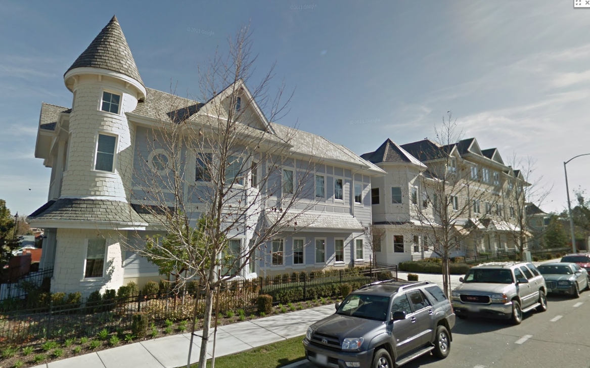
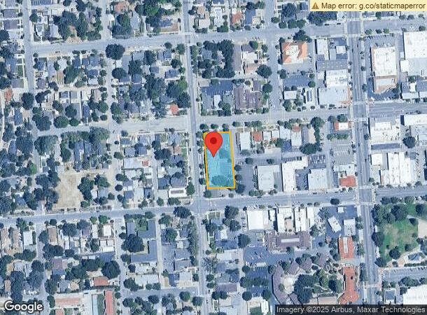
Property Record
1222 Vine St, Paso Robles, CA 93446

NEARBY LISTINGS FOR SALE OR LEASE
Property Detail
1222 Vine St
San Luis Obispo-Paso Robles-Arroyo Grande, CA
Springs Hotel
009-036-024
CY PR SPR HOTEL TR LTS 26 TO 30
Officebuilding
San Luis Obispo
X
California
06079C0389H
26
2023
0.69 AC
2024
North 101 Corridor
010103
San Luis Obispo/Paso Robles
19,750 SF
DEMOGRAPHICS near 1222 Vine St
1 Mile
3 Mile
5 Mile
2024 Total Population
6,691
30,798
37,050
2029 Population
6,724
30,578
36,683
Pop Growth 2024-2029
+ 0.49%
(0.71%)
(0.99%)
Average Age
40
40
41
2024 Total Households
2,705
11,323
13,733
HH Growth 2024-2029
+ 0.37%
(0.87%)
(1.17%)
Median Household Inc
$80,404
$77,551
$79,637
Avg Household Size
2.40
2.70
2.60
2024 Avg HH Vehicles
2.00
2.00
2.00
Median Home Value
$647,476
$628,520
$627,240
Median Year Built
1968
1986
1987
Nearby Places
- Restaurants
- Banks
- Shops
- Fitness
- Groceries
PUBLIC TRANSPORTATION
COMMUTER RAIL
Paso Robles Amtrak Station (Coast Starlight - Amtrak)
DRIVE
WALK
Distance
Paso Robles Amtrak Station (Coast Starlight - Amtrak)
1 min
12 min
0.6 mi
AIRPORT
San Luis County Regional
DRIVE
WALK
Distance
San Luis County Regional
46 min
34.2 mi
Freight Ports
The Port of Hueneme
DRIVE
WALK
Distance
The Port of Hueneme
203 min
161.2 mi
SALE & LEASE HISTORY
LISTING DATE
SALE/LEASE

Jul 20, 2018
For Sale
Nearby Properties
Address
Land Use
TOTAL SIZE
Lot Size
Zoning
Address
Land Use
TOTAL SIZE
Lot Size
Zoning
23,092 SF
1.38 AC
Address
Land Use
TOTAL SIZE
Lot Size
Zoning
197,140 SF
11.87 AC
R3
Address
Land Use
TOTAL SIZE
Lot Size
Zoning
115,054 SF
18.24 AC
PM
Address
Land Use
TOTAL SIZE
Lot Size
Zoning
282,906 SF
10 AC
R4
Address
Land Use
TOTAL SIZE
Lot Size
Zoning
129,241 SF
18.91 AC
POS
Address
Land Use
TOTAL SIZE
Lot Size
Zoning
72,406 SF
4.87 AC
OP
Address
Land Use
TOTAL SIZE
Lot Size
Zoning
63.59 AC
POS
Address
Land Use
TOTAL SIZE
Lot Size
Zoning
330,848 SF
30.24 AC
R315
Address
Land Use
TOTAL SIZE
Lot Size
Zoning
42,617 SF
4.79 AC
PM
Address
Land Use
TOTAL SIZE
Lot Size
Zoning
91,903 SF
5.10 AC
POS
Address
Land Use
TOTAL SIZE
Lot Size
Zoning
4.57 AC
PM
Address
Land Use
TOTAL SIZE
Lot Size
Zoning
48.88 AC
R1
Address
Land Use
TOTAL SIZE
Lot Size
Zoning
92,102 SF
2.79 AC
R4
Address
Land Use
TOTAL SIZE
Lot Size
Zoning
221,386 SF
10.45 AC
M
Address
Land Use
TOTAL SIZE
Lot Size
Zoning
11.53 AC
C3
Address
Land Use
TOTAL SIZE
Lot Size
Zoning
73,236 SF
2.45 AC
TC2
Address
Land Use
TOTAL SIZE
Lot Size
Zoning
49,520 SF
1.57 AC
C2
Address
Land Use
TOTAL SIZE
Lot Size
Zoning
82,249 SF
6.67 AC
Address
Land Use
TOTAL SIZE
Lot Size
Zoning
58,884 SF
2.34 AC
T4N
Address
Land Use
TOTAL SIZE
Lot Size
Zoning
4.25 AC
Address
Land Use
TOTAL SIZE
Lot Size
Zoning
65,931 SF
3.16 AC
PM
Address
Land Use
TOTAL SIZE
Lot Size
Zoning
89,417 SF
3.13 AC
T4N
Address
Land Use
TOTAL SIZE
Lot Size
Zoning
12.56 AC
CR
Address
Land Use
TOTAL SIZE
Lot Size
Zoning
1.59 AC
C3
Address
Land Use
TOTAL SIZE
Lot Size
Zoning
5.94 AC
R2
Address
Land Use
TOTAL SIZE
Lot Size
Zoning
74,710 SF
7.79 AC
R3
Address
Land Use
TOTAL SIZE
Lot Size
Zoning
18,400 SF
2.42 AC
TC1
Address
Land Use
TOTAL SIZE
Lot Size
Zoning
89,400 SF
7.97 AC
RC
Address
Land Use
TOTAL SIZE
Lot Size
Zoning
64,323 SF
2.56 AC
T4N
Address
Land Use
TOTAL SIZE
Lot Size
Zoning
46,269 SF
2.30 AC
C2
The World's #1 Commercial Real Estate Marketplace
Connect with us
© 2025 CoStar Group
The information above has been obtained from sources believed reliable. While we do not doubt its accuracy we have not verified it and make no guarantee, warranty or representation about it. It is your responsibility to independently confirm its accuracy and completeness. Any projections, opinions, assumptions, or estimates used are for example only and do not represent the current or future performance of the property. The value of this transaction to you depends on tax and other factors which should be evaluated by your tax, financial, and legal advisors. You and your advisors should conduct a careful, independent investigation of the property to determine to your satisfaction the suitability of the property for your needs.