No Photo
Property Record
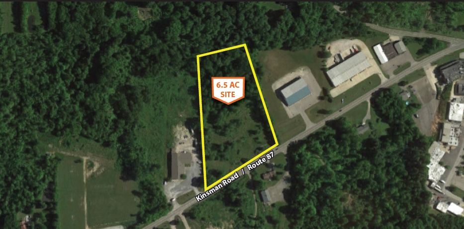
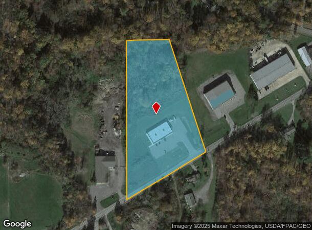
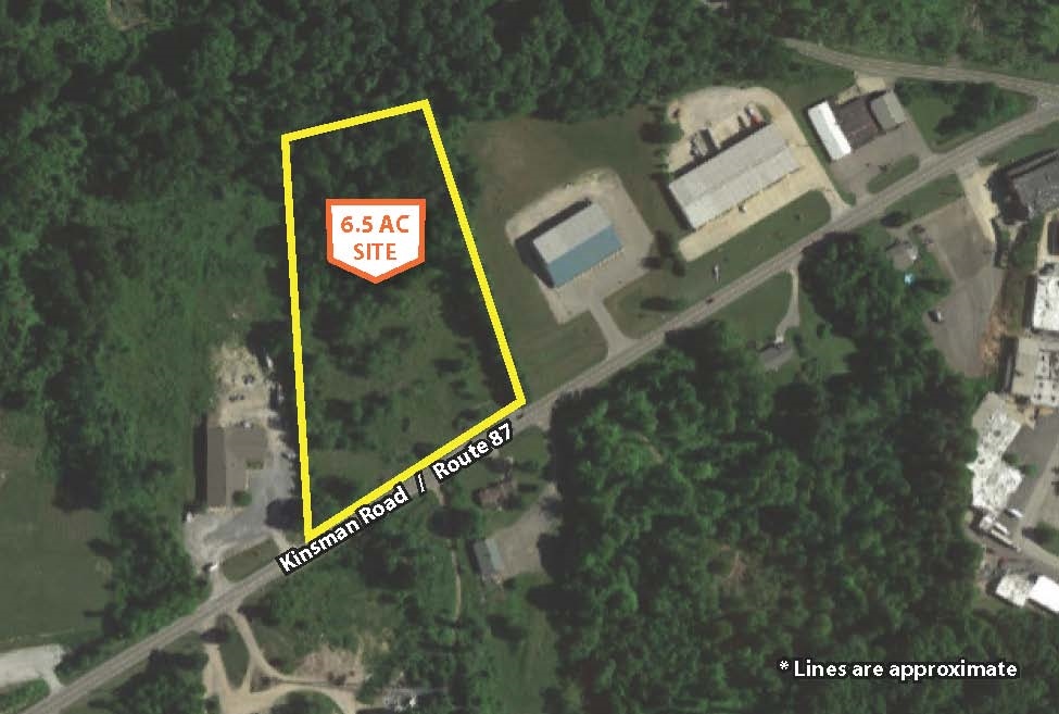
12222 Kinsman Rd, Newbury, OH 44065
NEARBY LISTINGS FOR SALE OR LEASE
-
-
View all Newbury listings for sale on LoopNet.com
Property Detail
12222 Kinsman Rd
23-131150
LOT 1 TR 2
Storebuilding
Geauga
X
Ohio
39055C0230D
1
2023
6.55 AC
2023
Geauga County
311400
Cleveland
8,980 SF
Cleveland-Elyria, OH
DEMOGRAPHICS near 12222 Kinsman Rd
1 Mile
3 Mile
5 Mile
2024 Total Population
744
6,036
13,751
2029 Population
743
5,994
13,684
Pop Growth 2024-2029
(0.13%)
(0.70%)
(0.49%)
Average Age
46
45
44
2024 Total Households
317
2,460
5,200
HH Growth 2024-2029
(0.32%)
(0.81%)
(0.60%)
Median Household Inc
$76,667
$82,169
$93,357
Avg Household Size
2.30
2.40
2.50
2024 Avg HH Vehicles
2.00
2.00
2.00
Median Home Value
$242,708
$247,262
$261,425
Median Year Built
1968
1966
1972
Nearby Places
- Restaurants
- Banks
- Shops
- Fitness
- Groceries
SALE & LEASE HISTORY
LISTING DATE
SALE/LEASE

Sep 24, 2016
For Sale
Nearby Properties
Address
Land Use
TOTAL SIZE
Lot Size
Zoning
Address
Land Use
TOTAL SIZE
Lot Size
Zoning
183,473 SF
70.84 AC
INST
Address
Land Use
TOTAL SIZE
Lot Size
Zoning
94,824 SF
13.09 AC
INST
Address
Land Use
TOTAL SIZE
Lot Size
Zoning
67,386 SF
15.87 AC
INST
Address
Land Use
TOTAL SIZE
Lot Size
Zoning
Address
Land Use
TOTAL SIZE
Lot Size
Zoning
672 SF
78.48 AC
AP
Address
Land Use
TOTAL SIZE
Lot Size
Zoning
28,789 SF
2.69 AC
S1
Address
Land Use
TOTAL SIZE
Lot Size
Zoning
73,490 SF
12.95 AC
M1
Address
Land Use
TOTAL SIZE
Lot Size
Zoning
4,984 SF
14.17 AC
B1
Address
Land Use
TOTAL SIZE
Lot Size
Zoning
6,148 SF
9.12 AC
R3
Address
Land Use
TOTAL SIZE
Lot Size
Zoning
4,640 SF
4.72 AC
R3
Address
Land Use
TOTAL SIZE
Lot Size
Zoning
43,500 SF
16.71 AC
INST
Address
Land Use
TOTAL SIZE
Lot Size
Zoning
1,844 SF
17.77 AC
M1
Address
Land Use
TOTAL SIZE
Lot Size
Zoning
27,052 SF
7.70 AC
INST
Address
Land Use
TOTAL SIZE
Lot Size
Zoning
21,530 SF
12.67 AC
Address
Land Use
TOTAL SIZE
Lot Size
Zoning
29,440 SF
5.10 AC
B2
Address
Land Use
TOTAL SIZE
Lot Size
Zoning
17,926 SF
5.41 AC
INST
Address
Land Use
TOTAL SIZE
Lot Size
Zoning
3,481 SF
100 AC
AP
Address
Land Use
TOTAL SIZE
Lot Size
Zoning
72,340 SF
10.33 AC
B1
Address
Land Use
TOTAL SIZE
Lot Size
Zoning
4,196 SF
126.21 AC
Address
Land Use
TOTAL SIZE
Lot Size
Zoning
4,524 SF
161.76 AC
INST
Address
Land Use
TOTAL SIZE
Lot Size
Zoning
702 SF
11.52 AC
Address
Land Use
TOTAL SIZE
Lot Size
Zoning
3,560 SF
5.44 AC
INST
Address
Land Use
TOTAL SIZE
Lot Size
Zoning
15,757 SF
3 AC
Address
Land Use
TOTAL SIZE
Lot Size
Zoning
5,159 SF
85.89 AC
R1
Address
Land Use
TOTAL SIZE
Lot Size
Zoning
11,504 SF
9.94 AC
Address
Land Use
TOTAL SIZE
Lot Size
Zoning
18,994 SF
2.28 AC
Address
Land Use
TOTAL SIZE
Lot Size
Zoning
15,196 SF
5 AC
M2
Address
Land Use
TOTAL SIZE
Lot Size
Zoning
1,500 SF
231.50 AC
R5
Address
Land Use
TOTAL SIZE
Lot Size
Zoning
4,506 SF
48.33 AC
R1
The World's #1 Commercial Real Estate Marketplace
Connect with us
© 2025 CoStar Group
The information above has been obtained from sources believed reliable. While we do not doubt its accuracy we have not verified it and make no guarantee, warranty or representation about it. It is your responsibility to independently confirm its accuracy and completeness. Any projections, opinions, assumptions, or estimates used are for example only and do not represent the current or future performance of the property. The value of this transaction to you depends on tax and other factors which should be evaluated by your tax, financial, and legal advisors. You and your advisors should conduct a careful, independent investigation of the property to determine to your satisfaction the suitability of the property for your needs.