Property Record
1228 S Main St, Lake Park, GA 31636
NEARBY LISTINGS FOR SALE OR LEASE
-
-
No Photo
-
View all Lake Park listings for sale on LoopNet.com
Property Detail
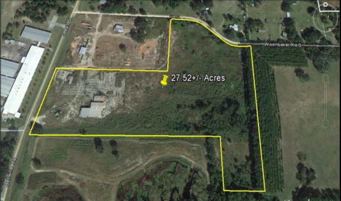
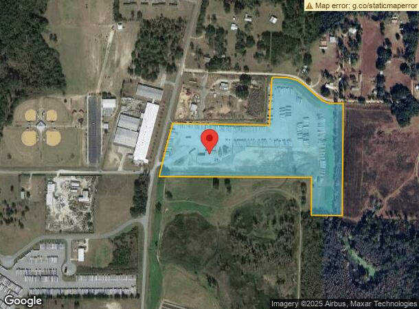
1228 S Main St
0225-016
Lake Park Industrial
Warehouse
LL 105, 106 & 126 LD 16 _ PCA 798
X
Lowndes
12047C0045C
Georgia
2024
27.17 AC
2024
Valdosta/Lake Park
011600
Other Market Areas
14,250 SF
Valdosta, GA
DEMOGRAPHICS near 1228 S Main St
1 Mile
3 Mile
5 Mile
2024 Total Population
422
5,167
8,745
2029 Population
441
5,441
9,134
Pop Growth 2024-2029
+ 4.50%
+ 5.30%
+ 4.45%
Average Age
43
39
39
2024 Total Households
174
2,077
3,442
HH Growth 2024-2029
+ 4.60%
+ 5.39%
+ 4.56%
Median Household Inc
$44,999
$43,972
$44,398
Avg Household Size
2.40
2.50
2.50
2024 Avg HH Vehicles
2.00
2.00
2.00
Median Home Value
$178,845
$189,137
$186,110
Median Year Built
1986
1992
1992
Nearby Places
- Restaurants
- Banks
- Shops
- Fitness
- Groceries
PUBLIC TRANSPORTATION
AIRPORT
Valdosta Regional
DRIVE
WALK
Distance
Valdosta Regional
18 min
11.8 mi
Freight Ports
Jacksonville Port
DRIVE
WALK
Distance
Jacksonville Port
128 min
111.4 mi
SALE & LEASE HISTORY
LISTING DATE
SALE/LEASE

Jun 08, 2017
For Sale
Nearby Properties
Address
Land Use
TOTAL SIZE
Lot Size
Zoning
Address
Land Use
TOTAL SIZE
Lot Size
Zoning
660,000 SF
89.77 AC
M-2
Address
Land Use
TOTAL SIZE
Lot Size
Zoning
43,512 SF
2.01 AC
C-H
Address
Land Use
TOTAL SIZE
Lot Size
Zoning
37,152 SF
9.86 AC
R-6,C-C
Address
Land Use
TOTAL SIZE
Lot Size
Zoning
79,884 SF
6.42 AC
M-2
Address
Land Use
TOTAL SIZE
Lot Size
Zoning
36,050 SF
12.49 AC
C-H
Address
Land Use
TOTAL SIZE
Lot Size
Zoning
40,500 SF
1.42 AC
C-H
Address
Land Use
TOTAL SIZE
Lot Size
Zoning
237,872 SF
22.07 AC
C-H
Address
Land Use
TOTAL SIZE
Lot Size
Zoning
76,020 SF
40.70 AC
M-2
Address
Land Use
TOTAL SIZE
Lot Size
Zoning
64,795 SF
6.02 AC
P-D
Address
Land Use
TOTAL SIZE
Lot Size
Zoning
38,400 SF
2.10 AC
R-10
Address
Land Use
TOTAL SIZE
Lot Size
Zoning
18,816 SF
18.78 AC
C-H
Address
Land Use
TOTAL SIZE
Lot Size
Zoning
25,520 SF
9.50 AC
R-15
Address
Land Use
TOTAL SIZE
Lot Size
Zoning
126,739 SF
6.37 AC
M-1
Address
Land Use
TOTAL SIZE
Lot Size
Zoning
17,600 SF
8.65 AC
C-C
Address
Land Use
TOTAL SIZE
Lot Size
Zoning
69,696 SF
4.59 AC
M-2
Address
Land Use
TOTAL SIZE
Lot Size
Zoning
2,000 SF
52.61 AC
M-1
Address
Land Use
TOTAL SIZE
Lot Size
Zoning
4,832 SF
7.12 AC
R-10
Address
Land Use
TOTAL SIZE
Lot Size
Zoning
27,292 SF
1.52 AC
C-H
Address
Land Use
TOTAL SIZE
Lot Size
Zoning
3,680 SF
26.64 AC
R-10
Address
Land Use
TOTAL SIZE
Lot Size
Zoning
1,418 SF
2.44 AC
C-H
Address
Land Use
TOTAL SIZE
Lot Size
Zoning
1,056 SF
17.34 AC
C-H
Address
Land Use
TOTAL SIZE
Lot Size
Zoning
47,500 SF
4.20 AC
C-H
Address
Land Use
TOTAL SIZE
Lot Size
Zoning
2,392 AC
E-A
Address
Land Use
TOTAL SIZE
Lot Size
Zoning
5,224 SF
1.80 AC
C-H
Address
Land Use
TOTAL SIZE
Lot Size
Zoning
1,466 SF
2.17 AC
C-H
Address
Land Use
TOTAL SIZE
Lot Size
Zoning
968 SF
1.45 AC
C-H
Address
Land Use
TOTAL SIZE
Lot Size
Zoning
9,600 SF
12.16 AC
R-10
Address
Land Use
TOTAL SIZE
Lot Size
Zoning
6,598 SF
6.03 AC
P-D
Address
Land Use
TOTAL SIZE
Lot Size
Zoning
13,770 SF
6.02 AC
C-H
Address
Land Use
TOTAL SIZE
Lot Size
Zoning
6,128 SF
3.50 AC
R-10
The World's #1 Commercial Real Estate Marketplace
Connect with us
© 2025 CoStar Group
The information above has been obtained from sources believed reliable. While we do not doubt its accuracy we have not verified it and make no guarantee, warranty or representation about it. It is your responsibility to independently confirm its accuracy and completeness. Any projections, opinions, assumptions, or estimates used are for example only and do not represent the current or future performance of the property. The value of this transaction to you depends on tax and other factors which should be evaluated by your tax, financial, and legal advisors. You and your advisors should conduct a careful, independent investigation of the property to determine to your satisfaction the suitability of the property for your needs.