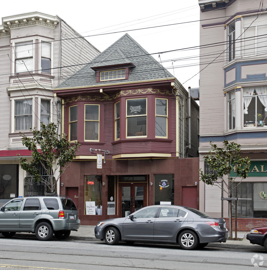
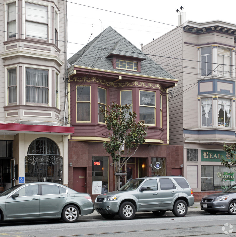
Property Record
1687 Church St, San Francisco, CA 94131

NEARBY LISTINGS FOR SALE OR LEASE
Property Detail
1687 Church St
San Francisco
Portion Of Horners Addition
San Francisco-Redwood City-South San Francisco, CA
BLK 54
6618-020
San Francisco
Retailwithmorethanonenonretailuse
California
2023
20
2023
0.06 AC
021500
Southern City
1,888 SF
DEMOGRAPHICS near 1687 Church St
1 Mile
3 Mile
5 Mile
2024 Total Population
68,767
503,101
856,285
2029 Population
63,850
464,038
792,856
Pop Growth 2024-2029
(7.15%)
(7.76%)
(7.41%)
Average Age
42
42
42
2024 Total Households
28,554
200,340
356,461
HH Growth 2024-2029
(7.68%)
(8.08%)
(7.76%)
Median Household Inc
$168,742
$123,794
$124,168
Avg Household Size
2.30
2.30
2.30
2024 Avg HH Vehicles
1.00
1.00
1.00
Median Home Value
$1,115,526
$1,088,925
$1,092,933
Median Year Built
1947
1949
1949
Nearby Places
- Restaurants
- Banks
- Shops
- Fitness
- Groceries
PUBLIC TRANSPORTATION
TRANSIT/SUBWAY
Church And 29Th Street (J Church - San Francisco Municipal Railway (MUNI Metro))
DRIVE
WALK
Distance
Church And 29Th Street (J Church - San Francisco Municipal Railway (MUNI Metro))
0 min
0 min
0.0 mi
J Line Outbound (J Church - San Francisco Municipal Railway (MUNI Metro))
DRIVE
WALK
Distance
J Line Outbound (J Church - San Francisco Municipal Railway (MUNI Metro))
0 min
1 min
0.1 mi
Church And 27Th Street (J Church - San Francisco Municipal Railway (MUNI Metro))
DRIVE
WALK
Distance
Church And 27Th Street (J Church - San Francisco Municipal Railway (MUNI Metro))
1 min
4 min
0.2 mi
30Th Street And Dolores (J Church - San Francisco Municipal Railway (MUNI Metro))
DRIVE
WALK
Distance
30Th Street And Dolores (J Church - San Francisco Municipal Railway (MUNI Metro))
1 min
4 min
0.2 mi
San Jose Ave & Randall St (J Church - San Francisco Municipal Railway (MUNI Metro))
DRIVE
WALK
Distance
San Jose Ave & Randall St (J Church - San Francisco Municipal Railway (MUNI Metro))
1 min
8 min
0.4 mi
COMMUTER RAIL
Bayshore Caltrain Station (Local - Caltrain (Caltrain))
DRIVE
WALK
Distance
Bayshore Caltrain Station (Local - Caltrain (Caltrain))
8 min
4.8 mi
22Nd Street (Caltrain - Caltrain (Caltrain))
DRIVE
WALK
Distance
22Nd Street (Caltrain - Caltrain (Caltrain))
9 min
5.9 mi
AIRPORT
San Francisco International
DRIVE
WALK
Distance
San Francisco International
20 min
12.7 mi
Metro Oakland International
DRIVE
WALK
Distance
Metro Oakland International
37 min
23.0 mi
Freight Ports
Port of San Francisco
DRIVE
WALK
Distance
Port of San Francisco
13 min
4.7 mi
SALE & LEASE HISTORY
LISTING DATE
SALE/LEASE

Jul 15, 2024
For Sale
Jan 19, 2023
For Sale
Nearby Properties
Address
Land Use
TOTAL SIZE
Lot Size
Zoning
Address
Land Use
TOTAL SIZE
Lot Size
Zoning
10.92 AC
Address
Land Use
TOTAL SIZE
Lot Size
Zoning
750,370 SF
3.25 AC
MBR3
Address
Land Use
TOTAL SIZE
Lot Size
Zoning
248,303 SF
4.35 AC
Address
Land Use
TOTAL SIZE
Lot Size
Zoning
717,234 SF
3.47 AC
UMU
Address
Land Use
TOTAL SIZE
Lot Size
Zoning
696,431 SF
0.97 AC
C3G
Address
Land Use
TOTAL SIZE
Lot Size
Zoning
266,143 SF
4 AC
C-3-R
Address
Land Use
TOTAL SIZE
Lot Size
Zoning
885,581 SF
5.20 AC
M2
Address
Land Use
TOTAL SIZE
Lot Size
Zoning
1.52 AC
C3G
Address
Land Use
TOTAL SIZE
Lot Size
Zoning
2.74 AC
Address
Land Use
TOTAL SIZE
Lot Size
Zoning
313,306 SF
1.23 AC
WMUG
Address
Land Use
TOTAL SIZE
Lot Size
Zoning
314,826 SF
1.85 AC
MB-RA
Address
Land Use
TOTAL SIZE
Lot Size
Zoning
10.92 AC
Address
Land Use
TOTAL SIZE
Lot Size
Zoning
302,084 SF
0.88 AC
MBO
Address
Land Use
TOTAL SIZE
Lot Size
Zoning
393,918 SF
3.36 AC
WMUG
Address
Land Use
TOTAL SIZE
Lot Size
Zoning
393,918 SF
3.36 AC
WMUG
Address
Land Use
TOTAL SIZE
Lot Size
Zoning
291,522 SF
6.66 AC
CM
Address
Land Use
TOTAL SIZE
Lot Size
Zoning
24.37 AC
Address
Land Use
TOTAL SIZE
Lot Size
Zoning
241,659 SF
3.76 AC
Address
Land Use
TOTAL SIZE
Lot Size
Zoning
230,853 SF
3.76 AC
Address
Land Use
TOTAL SIZE
Lot Size
Zoning
674,317 SF
3.36 AC
UMU
Address
Land Use
TOTAL SIZE
Lot Size
Zoning
222,000 SF
1 AC
MB-RA
Address
Land Use
TOTAL SIZE
Lot Size
Zoning
10.92 AC
Address
Land Use
TOTAL SIZE
Lot Size
Zoning
342,727 SF
1.36 AC
C3G
Address
Land Use
TOTAL SIZE
Lot Size
Zoning
2.93 AC
Address
Land Use
TOTAL SIZE
Lot Size
Zoning
718 SF
18.55 AC
RH2
Address
Land Use
TOTAL SIZE
Lot Size
Zoning
411,904 SF
21.74 AC
C2
Address
Land Use
TOTAL SIZE
Lot Size
Zoning
248,974 SF
0.88 AC
MBO
Address
Land Use
TOTAL SIZE
Lot Size
Zoning
250,884 SF
1.66 AC
MB-RA
Address
Land Use
TOTAL SIZE
Lot Size
Zoning
1.74 AC
WMUG
Address
Land Use
TOTAL SIZE
Lot Size
Zoning
2.22 AC
M1
The World's #1 Commercial Real Estate Marketplace
Connect with us
© 2025 CoStar Group
The information above has been obtained from sources believed reliable. While we do not doubt its accuracy we have not verified it and make no guarantee, warranty or representation about it. It is your responsibility to independently confirm its accuracy and completeness. Any projections, opinions, assumptions, or estimates used are for example only and do not represent the current or future performance of the property. The value of this transaction to you depends on tax and other factors which should be evaluated by your tax, financial, and legal advisors. You and your advisors should conduct a careful, independent investigation of the property to determine to your satisfaction the suitability of the property for your needs.