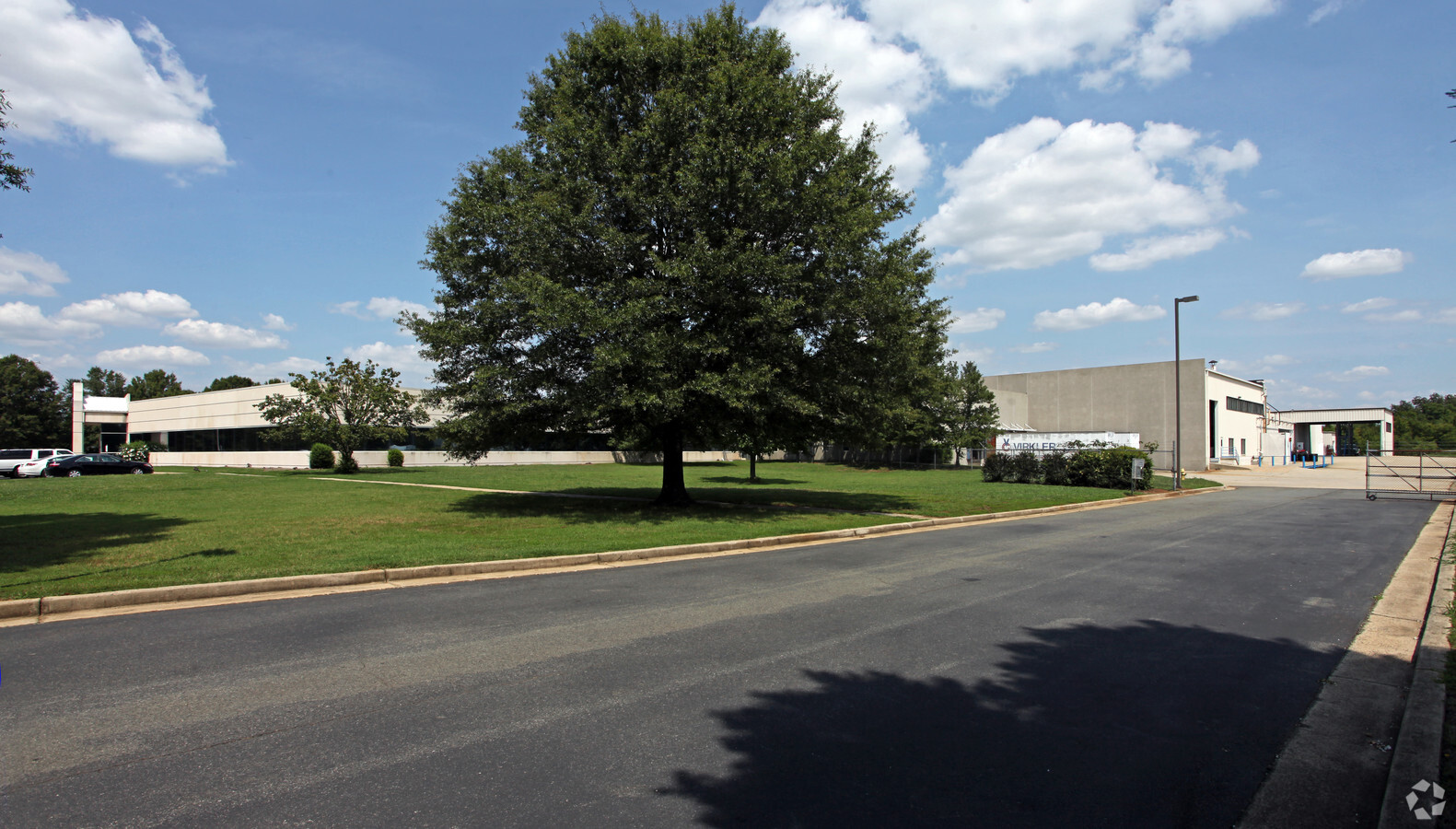
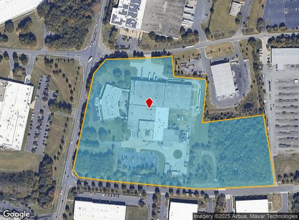
Property Record
12345 Steele Creek Rd, Charlotte, NC 28273


NEARBY LISTINGS FOR SALE OR LEASE
Property Detail
12345 Steele Creek Rd
201-421-02
Property/Steele Crk Assoc Ltd
Industrialgeneral
Mecklenburg
X
North Carolina
3710450000K
2
2023
19.03 AC
2023
State Line
005930
Charlotte
138,775 SF
Charlotte-Concord-Gastonia, NC-SC
DEMOGRAPHICS near 12345 Steele Creek Rd
1 Mile
3 Mile
5 Mile
2024 Total Population
6,346
55,738
119,598
2029 Population
6,739
58,975
129,638
Pop Growth 2024-2029
+ 6.19%
+ 5.81%
+ 8.39%
Average Age
38
37
38
2024 Total Households
2,430
21,920
46,722
HH Growth 2024-2029
+ 6.17%
+ 5.86%
+ 8.47%
Median Household Inc
$81,822
$85,585
$89,598
Avg Household Size
2.50
2.50
2.50
2024 Avg HH Vehicles
2.00
2.00
2.00
Median Home Value
$290,122
$302,376
$332,600
Median Year Built
2003
2004
2004
Nearby Places
- Restaurants
- Banks
- Shops
- Fitness
- Groceries
PUBLIC TRANSPORTATION
AIRPORT
Charlotte/Douglas International
DRIVE
WALK
Distance
Charlotte/Douglas International
17 min
8.0 mi
Concord-Padgett Regional
DRIVE
WALK
Distance
Concord-Padgett Regional
38 min
29.6 mi
Freight Ports
North Charleston Terminal
DRIVE
WALK
Distance
North Charleston Terminal
218 min
190.9 mi
Nearby Properties
Address
Land Use
TOTAL SIZE
Lot Size
Zoning
Address
Land Use
TOTAL SIZE
Lot Size
Zoning
432,123 SF
36.75 AC
R17MFCD
Address
Land Use
TOTAL SIZE
Lot Size
Zoning
1,255,063 SF
292.46 AC
I2
Address
Land Use
TOTAL SIZE
Lot Size
Zoning
395,382 SF
9.84 AC
MUDDO
Address
Land Use
TOTAL SIZE
Lot Size
Zoning
283,424 SF
24.95 AC
R17MFCD
Address
Land Use
TOTAL SIZE
Lot Size
Zoning
399,178 SF
17.59 AC
Address
Land Use
TOTAL SIZE
Lot Size
Zoning
369,622 SF
26.28 AC
R17MFCD
Address
Land Use
TOTAL SIZE
Lot Size
Zoning
252,275 SF
20.23 AC
Address
Land Use
TOTAL SIZE
Lot Size
Zoning
293,943 SF
12.90 AC
Address
Land Use
TOTAL SIZE
Lot Size
Zoning
289,148 SF
17.12 AC
Address
Land Use
TOTAL SIZE
Lot Size
Zoning
280,293 SF
25.47 AC
R3
Address
Land Use
TOTAL SIZE
Lot Size
Zoning
250,307 SF
15.53 AC
R17MFCD
Address
Land Use
TOTAL SIZE
Lot Size
Zoning
229,094 SF
7.29 AC
R3
Address
Land Use
TOTAL SIZE
Lot Size
Zoning
1,396,936 SF
68.78 AC
I2
Address
Land Use
TOTAL SIZE
Lot Size
Zoning
899,731 SF
73.49 AC
Address
Land Use
TOTAL SIZE
Lot Size
Zoning
269,639 SF
15.32 AC
R17MFCD
Address
Land Use
TOTAL SIZE
Lot Size
Zoning
254,393 SF
12.48 AC
Address
Land Use
TOTAL SIZE
Lot Size
Zoning
136,576 SF
4.75 AC
Address
Land Use
TOTAL SIZE
Lot Size
Zoning
245,573 SF
23.62 AC
R12MFCD
Address
Land Use
TOTAL SIZE
Lot Size
Zoning
275,215 SF
12.35 AC
R17MFCD
Address
Land Use
TOTAL SIZE
Lot Size
Zoning
857,532 SF
73.57 AC
I1
Address
Land Use
TOTAL SIZE
Lot Size
Zoning
218,322 SF
15.93 AC
R17MFCD
Address
Land Use
TOTAL SIZE
Lot Size
Zoning
220,232 SF
15.45 AC
R15MFCD
Address
Land Use
TOTAL SIZE
Lot Size
Zoning
415,871 SF
66.17 AC
R3
Address
Land Use
TOTAL SIZE
Lot Size
Zoning
200,765 SF
7.71 AC
Address
Land Use
TOTAL SIZE
Lot Size
Zoning
213,739 SF
9.79 AC
MUDDO
Address
Land Use
TOTAL SIZE
Lot Size
Zoning
873,356 SF
52.31 AC
I2
Address
Land Use
TOTAL SIZE
Lot Size
Zoning
221,746 SF
8.82 AC
O-2(CD)
Address
Land Use
TOTAL SIZE
Lot Size
Zoning
182,235 SF
18.29 AC
R17MF
Address
Land Use
TOTAL SIZE
Lot Size
Zoning
163,002 SF
5.65 AC
R17MF
Address
Land Use
TOTAL SIZE
Lot Size
Zoning
198,432 SF
16.97 AC
R17MFCD
The World's #1 Commercial Real Estate Marketplace
Connect with us
© 2025 CoStar Group
The information above has been obtained from sources believed reliable. While we do not doubt its accuracy we have not verified it and make no guarantee, warranty or representation about it. It is your responsibility to independently confirm its accuracy and completeness. Any projections, opinions, assumptions, or estimates used are for example only and do not represent the current or future performance of the property. The value of this transaction to you depends on tax and other factors which should be evaluated by your tax, financial, and legal advisors. You and your advisors should conduct a careful, independent investigation of the property to determine to your satisfaction the suitability of the property for your needs.