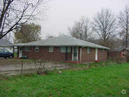
Property Record
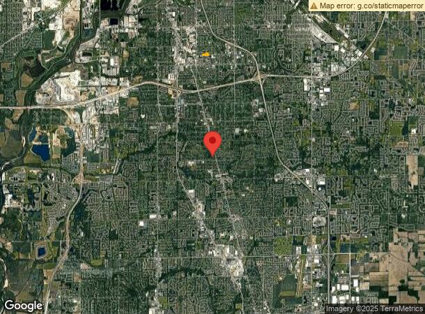
1236 National Ave, Indianapolis, IN 46227
NEARBY LISTINGS FOR SALE OR LEASE
-
-
View all Indianapolis listings for sale on LoopNet.com
Property Detail
1236 National Ave
Indianapolis-Carmel-Anderson, IN
Woodlawn Gardens 2Nd Sec
49-10-30-106-001.085-501
WOODLAWN GARDENS 2ND SEC PT L244 THRU L256 SURVEY TR55 & TR57 THRU TR60 & PT OF VAC BOYD AVE BEG SW COR L244 P.O.B. N130? E576? N7.5 E65? N142.5? E65? S142.5? E130? S142.5 W65? N5? W470.07? N10? W75? S10? W225.94? TO BEG 2.947 AC
Privateschool
Marion
X
Indiana
18097C0234F
244
2023
2.95 AC
2023
University Heights
381002
Indianapolis
80,348 SF
DEMOGRAPHICS near 1236 National Ave
1 Mile
3 Mile
5 Mile
2024 Total Population
11,932
84,272
226,792
2029 Population
11,942
83,838
225,869
Pop Growth 2024-2029
+ 0.08%
(0.51%)
(0.41%)
Average Age
33
37
36
2024 Total Households
4,009
33,508
93,031
HH Growth 2024-2029
+ 0.02%
(0.58%)
(0.36%)
Median Household Inc
$43,716
$53,617
$59,000
Avg Household Size
2.40
2.40
2.30
2024 Avg HH Vehicles
2.00
2.00
2.00
Median Home Value
$126,474
$160,577
$176,277
Median Year Built
1958
1959
1965
Nearby Places
- Restaurants
- Banks
- Shops
- Fitness
- Groceries
PUBLIC TRANSPORTATION
COMMUTER RAIL
Indianapolis (Cardinal - Amtrak)
DRIVE
WALK
Distance
Indianapolis (Cardinal - Amtrak)
12 min
6.6 mi
AIRPORT
Indianapolis International
DRIVE
WALK
Distance
Indianapolis International
29 min
16.8 mi
Freight Ports
Port of Toledo
DRIVE
WALK
Distance
Port of Toledo
280 min
233.3 mi
Nearby Properties
Address
Land Use
TOTAL SIZE
Lot Size
Zoning
Address
Land Use
TOTAL SIZE
Lot Size
Zoning
295,161 SF
70.54 AC
Address
Land Use
TOTAL SIZE
Lot Size
Zoning
3,586 SF
30.28 AC
ZO01
Address
Land Use
TOTAL SIZE
Lot Size
Zoning
5,279 SF
18.07 AC
ZO01
Address
Land Use
TOTAL SIZE
Lot Size
Zoning
6,786 SF
45.81 AC
Address
Land Use
TOTAL SIZE
Lot Size
Zoning
3,286 SF
26.39 AC
Address
Land Use
TOTAL SIZE
Lot Size
Zoning
110,598 SF
22.82 AC
ZO01
Address
Land Use
TOTAL SIZE
Lot Size
Zoning
23,040 SF
9.28 AC
ZO01
Address
Land Use
TOTAL SIZE
Lot Size
Zoning
4,476 SF
12.18 AC
Address
Land Use
TOTAL SIZE
Lot Size
Zoning
21,784 SF
30.75 AC
ZO01
Address
Land Use
TOTAL SIZE
Lot Size
Zoning
3,818 SF
15.24 AC
Address
Land Use
TOTAL SIZE
Lot Size
Zoning
51,196 SF
50.61 AC
ZO01
Address
Land Use
TOTAL SIZE
Lot Size
Zoning
2,486 SF
13.75 AC
ZO01
Address
Land Use
TOTAL SIZE
Lot Size
Zoning
1,102 SF
9.98 AC
Address
Land Use
TOTAL SIZE
Lot Size
Zoning
226,129 SF
18.69 AC
ZO01
Address
Land Use
TOTAL SIZE
Lot Size
Zoning
2,911 SF
24.62 AC
ZO01
Address
Land Use
TOTAL SIZE
Lot Size
Zoning
5,665 SF
25.25 AC
ZO01
Address
Land Use
TOTAL SIZE
Lot Size
Zoning
1,925 SF
29.98 AC
Address
Land Use
TOTAL SIZE
Lot Size
Zoning
37,718 SF
11.77 AC
ZO01
Address
Land Use
TOTAL SIZE
Lot Size
Zoning
3,337 SF
21.53 AC
ZO01
Address
Land Use
TOTAL SIZE
Lot Size
Zoning
3,003 SF
3.52 AC
ZO01
Address
Land Use
TOTAL SIZE
Lot Size
Zoning
3,202 SF
18.62 AC
ZO01
Address
Land Use
TOTAL SIZE
Lot Size
Zoning
41,565 SF
8.94 AC
ZO01
Address
Land Use
TOTAL SIZE
Lot Size
Zoning
1,960 SF
23.76 AC
Address
Land Use
TOTAL SIZE
Lot Size
Zoning
3,701 SF
26 AC
ZO01
Address
Land Use
TOTAL SIZE
Lot Size
Zoning
26,192 SF
5.49 AC
ZO01
Address
Land Use
TOTAL SIZE
Lot Size
Zoning
3,793 SF
23.47 AC
ZO01
Address
Land Use
TOTAL SIZE
Lot Size
Zoning
3,782 SF
44.43 AC
ZO01
Address
Land Use
TOTAL SIZE
Lot Size
Zoning
3,257 SF
19.49 AC
Address
Land Use
TOTAL SIZE
Lot Size
Zoning
3,935 SF
36.08 AC
ZO01
The World's #1 Commercial Real Estate Marketplace
Connect with us
© 2025 CoStar Group
The information above has been obtained from sources believed reliable. While we do not doubt its accuracy we have not verified it and make no guarantee, warranty or representation about it. It is your responsibility to independently confirm its accuracy and completeness. Any projections, opinions, assumptions, or estimates used are for example only and do not represent the current or future performance of the property. The value of this transaction to you depends on tax and other factors which should be evaluated by your tax, financial, and legal advisors. You and your advisors should conduct a careful, independent investigation of the property to determine to your satisfaction the suitability of the property for your needs.