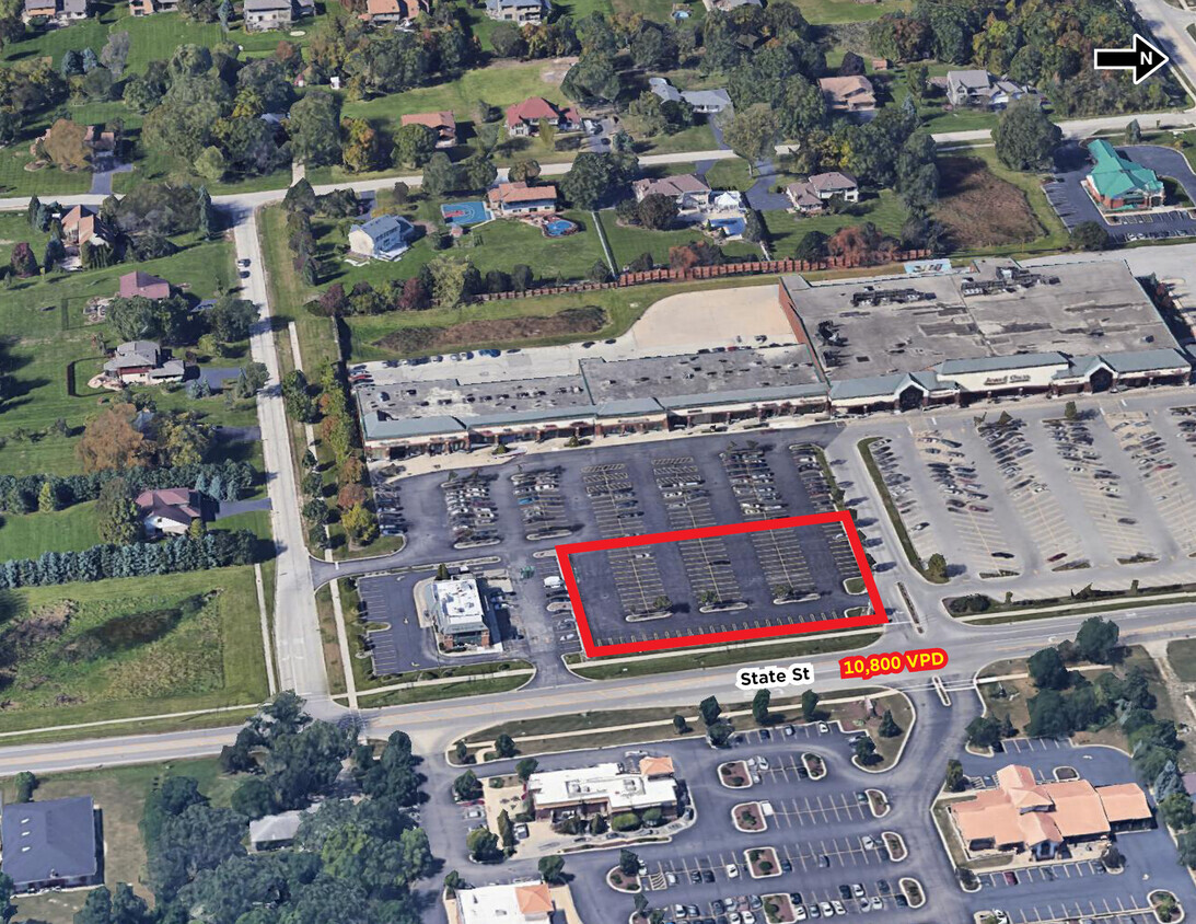
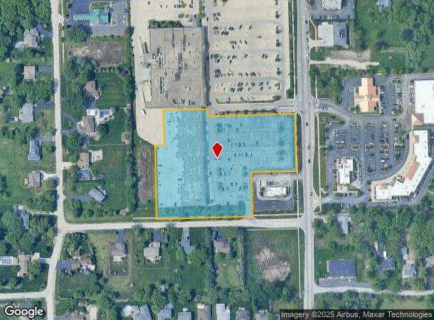
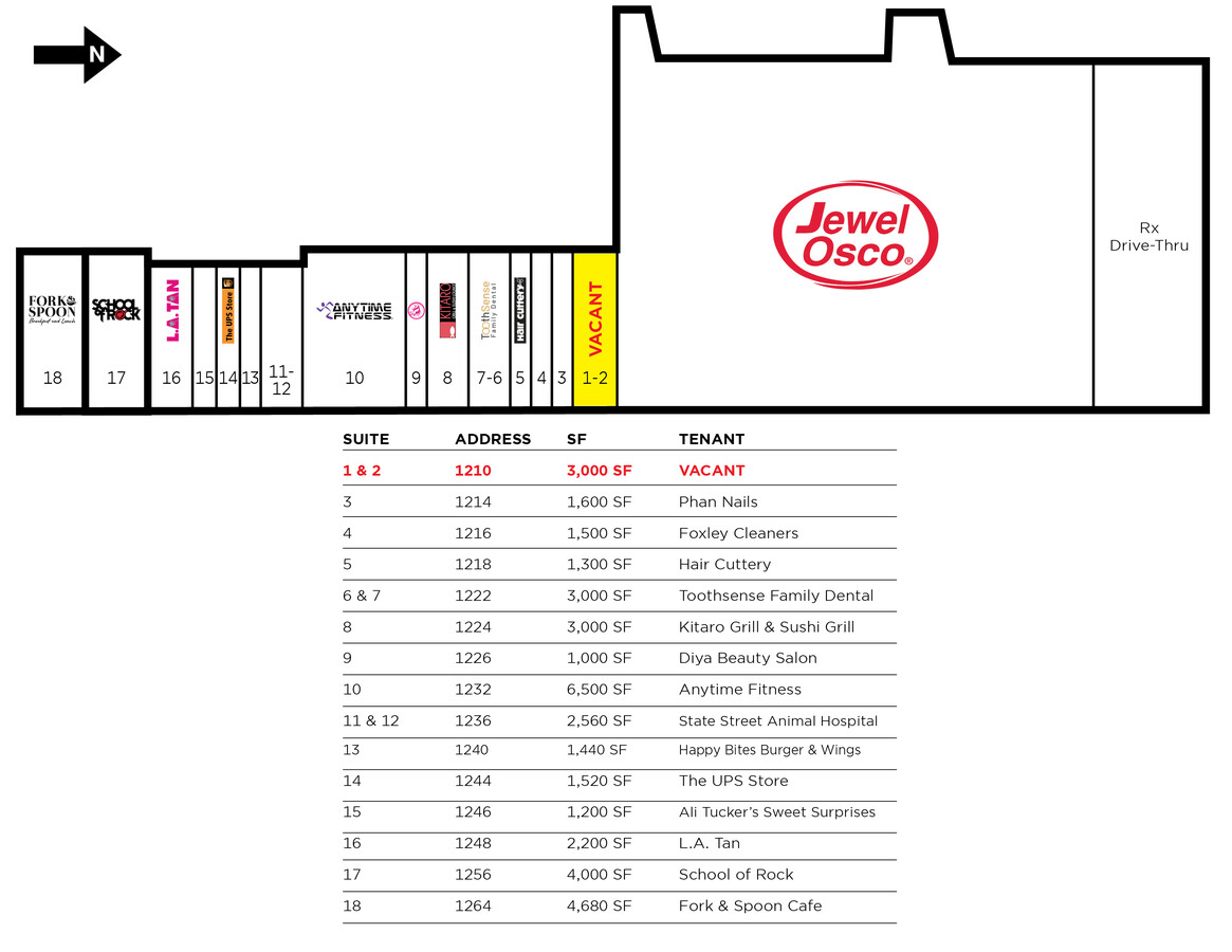
Property Record
1236 State St, Lemont, IL 60439
NEARBY LISTINGS FOR SALE OR LEASE
Property Detail
1236 State St
22-32-107-014-0000
Emerald Acres
Commercialbuilding
Cook
X
Illinois
17197C0070G
2
2022
4.82 AC
2024
Joliet/Central Will
824005
Chicago
38,950 SF
Chicago-Naperville-Elgin, IL-IN-WI
DEMOGRAPHICS near 1236 State St
1 Mile
3 Mile
5 Mile
2024 Total Population
7,870
27,433
96,184
2029 Population
7,621
26,797
94,874
Pop Growth 2024-2029
(3.16%)
(2.32%)
(1.36%)
Average Age
43
43
41
2024 Total Households
2,854
10,026
33,691
HH Growth 2024-2029
(3.50%)
(2.53%)
(1.43%)
Median Household Inc
$125,380
$112,380
$96,539
Avg Household Size
2.70
2.70
2.80
2024 Avg HH Vehicles
2.00
2.00
2.00
Median Home Value
$394,444
$394,234
$324,216
Median Year Built
1990
1989
1984
Nearby Places
- Restaurants
- Banks
- Shops
- Fitness
- Groceries
PUBLIC TRANSPORTATION
COMMUTER RAIL
Lemont Station (Heritage Corridor Line - Northeast Illinois Regional Commuter Railroad (Metra))
DRIVE
WALK
Distance
Lemont Station (Heritage Corridor Line - Northeast Illinois Regional Commuter Railroad (Metra))
3 min
1.6 mi
Romeoville (Heritage Corridor - Metra)
DRIVE
WALK
Distance
Romeoville (Heritage Corridor - Metra)
9 min
4.2 mi
AIRPORT
Chicago Midway International
DRIVE
WALK
Distance
Chicago Midway International
29 min
19.4 mi
Chicago O'Hare International
DRIVE
WALK
Distance
Chicago O'Hare International
46 min
30.9 mi
Freight Ports
Port Milwaukee
DRIVE
WALK
Distance
Port Milwaukee
127 min
102.6 mi
SALE & LEASE HISTORY
LISTING DATE
SALE/LEASE

Jun 02, 2023
For Lease
Nearby Properties
Address
Land Use
TOTAL SIZE
Lot Size
Zoning
Address
Land Use
TOTAL SIZE
Lot Size
Zoning
122.95 AC
Address
Land Use
TOTAL SIZE
Lot Size
Zoning
32.82 AC
Address
Land Use
TOTAL SIZE
Lot Size
Zoning
115.36 AC
Address
Land Use
TOTAL SIZE
Lot Size
Zoning
52.19 AC
Address
Land Use
TOTAL SIZE
Lot Size
Zoning
49.91 AC
Address
Land Use
TOTAL SIZE
Lot Size
Zoning
24.65 AC
Address
Land Use
TOTAL SIZE
Lot Size
Zoning
165.89 AC
Address
Land Use
TOTAL SIZE
Lot Size
Zoning
506,726 SF
28.54 AC
Address
Land Use
TOTAL SIZE
Lot Size
Zoning
264,310 SF
12.21 AC
I
Address
Land Use
TOTAL SIZE
Lot Size
Zoning
500,160 SF
25.07 AC
Address
Land Use
TOTAL SIZE
Lot Size
Zoning
19.21 AC
Address
Land Use
TOTAL SIZE
Lot Size
Zoning
17.18 AC
Address
Land Use
TOTAL SIZE
Lot Size
Zoning
74,782 SF
5.15 AC
Address
Land Use
TOTAL SIZE
Lot Size
Zoning
18.96 AC
Address
Land Use
TOTAL SIZE
Lot Size
Zoning
263,010 SF
13.56 AC
I
Address
Land Use
TOTAL SIZE
Lot Size
Zoning
17.18 AC
Address
Land Use
TOTAL SIZE
Lot Size
Zoning
19.01 AC
Address
Land Use
TOTAL SIZE
Lot Size
Zoning
8,577 SF
160 AC
Address
Land Use
TOTAL SIZE
Lot Size
Zoning
121.17 AC
Address
Land Use
TOTAL SIZE
Lot Size
Zoning
119,270 SF
7 AC
I
Address
Land Use
TOTAL SIZE
Lot Size
Zoning
24.85 AC
Address
Land Use
TOTAL SIZE
Lot Size
Zoning
274,325 SF
16.32 AC
Address
Land Use
TOTAL SIZE
Lot Size
Zoning
253,622 SF
13.09 AC
Address
Land Use
TOTAL SIZE
Lot Size
Zoning
180,022 SF
9.49 AC
Address
Land Use
TOTAL SIZE
Lot Size
Zoning
165,524 SF
9.36 AC
I
Address
Land Use
TOTAL SIZE
Lot Size
Zoning
308,913 SF
13.68 AC
I
Address
Land Use
TOTAL SIZE
Lot Size
Zoning
26.19 AC
Address
Land Use
TOTAL SIZE
Lot Size
Zoning
153,050 SF
8.95 AC
Address
Land Use
TOTAL SIZE
Lot Size
Zoning
197,558 SF
15.36 AC
I
Address
Land Use
TOTAL SIZE
Lot Size
Zoning
9.59 AC
The World's #1 Commercial Real Estate Marketplace
Connect with us
© 2025 CoStar Group
The information above has been obtained from sources believed reliable. While we do not doubt its accuracy we have not verified it and make no guarantee, warranty or representation about it. It is your responsibility to independently confirm its accuracy and completeness. Any projections, opinions, assumptions, or estimates used are for example only and do not represent the current or future performance of the property. The value of this transaction to you depends on tax and other factors which should be evaluated by your tax, financial, and legal advisors. You and your advisors should conduct a careful, independent investigation of the property to determine to your satisfaction the suitability of the property for your needs.