No Photo
Property Record
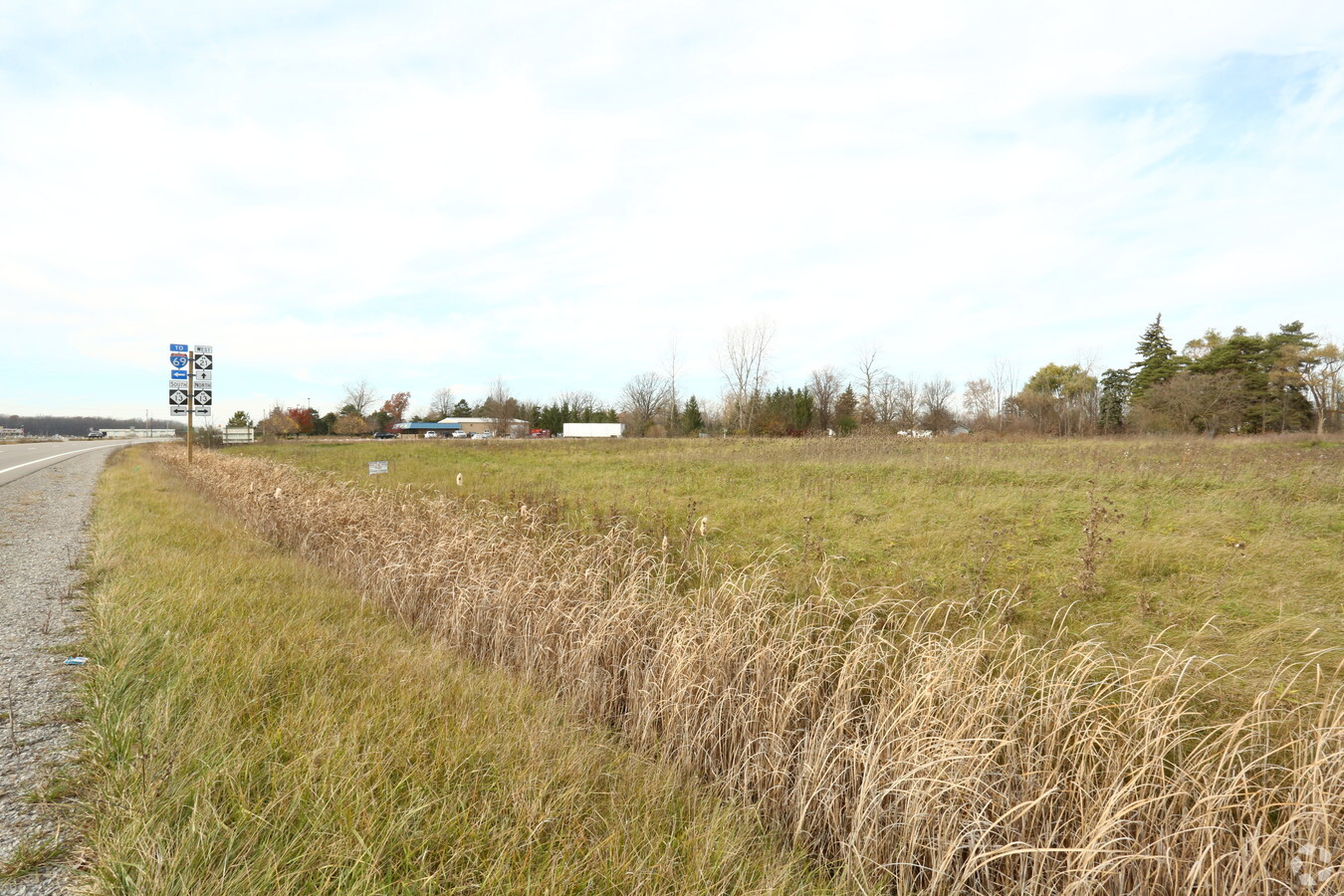
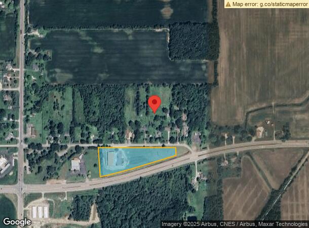
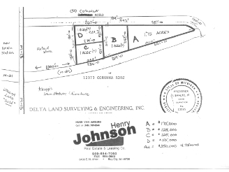
12373 Old Corunna Rd, Lennon, MI 48449
NEARBY LISTINGS FOR SALE OR LEASE
-
-
View all Lennon listings for sale on LoopNet.com
Property Detail
12373 Old Corunna Rd
04-19-100-004
ALL THAT PART OF W 3/4 OF NE 1/4 OF NW FR 1/4 LYING N OF HWY M-21 SEC 19 T7N R5E (78)
Commercialacreage
Genesee
X
Michigan
26155C0195C
4.73 AC
2024
Flint
2024
Detroit
012703
Flint, MI
DEMOGRAPHICS near 12373 Old Corunna Rd
1 Mile
3 Mile
5 Mile
2024 Total Population
353
2,973
12,053
2029 Population
344
2,902
11,790
Pop Growth 2024-2029
(2.55%)
(2.39%)
(2.18%)
Average Age
44
43
44
2024 Total Households
141
1,175
4,842
HH Growth 2024-2029
(2.84%)
(2.47%)
(2.02%)
Median Household Inc
$57,352
$52,564
$69,986
Avg Household Size
2.50
2.50
2.50
2024 Avg HH Vehicles
2.00
2.00
2.00
Median Home Value
$176,229
$175,363
$174,781
Median Year Built
1965
1970
1972
Nearby Places
- Restaurants
- Banks
- Shops
- Fitness
- Groceries
PUBLIC TRANSPORTATION
COMMUTER RAIL
Durand Amtrak Station (Blue Water - Amtrak)
DRIVE
WALK
Distance
Durand Amtrak Station (Blue Water - Amtrak)
16 min
8.3 mi
AIRPORT
Bishop International
DRIVE
WALK
Distance
Bishop International
27 min
12.5 mi
Freight Ports
Port of Toledo
DRIVE
WALK
Distance
Port of Toledo
145 min
121.0 mi
SALE & LEASE HISTORY
LISTING DATE
SALE/LEASE

Jan 23, 2019
For Sale
Dec 02, 2016
For Sale
Nearby Properties
Address
Land Use
TOTAL SIZE
Lot Size
Zoning
Address
Land Use
TOTAL SIZE
Lot Size
Zoning
Address
Land Use
TOTAL SIZE
Lot Size
Zoning
4,241 SF
107.20 AC
RMH,MOB
Address
Land Use
TOTAL SIZE
Lot Size
Zoning
Address
Land Use
TOTAL SIZE
Lot Size
Zoning
11.10 AC
Address
Land Use
TOTAL SIZE
Lot Size
Zoning
32.90 AC
Address
Land Use
TOTAL SIZE
Lot Size
Zoning
1,326 SF
49 AC
RA,AGRI
Address
Land Use
TOTAL SIZE
Lot Size
Zoning
7.70 AC
Address
Land Use
TOTAL SIZE
Lot Size
Zoning
21,104 SF
7.83 AC
GC,GENE
Address
Land Use
TOTAL SIZE
Lot Size
Zoning
156.20 AC
Address
Land Use
TOTAL SIZE
Lot Size
Zoning
120 AC
Address
Land Use
TOTAL SIZE
Lot Size
Zoning
92.60 AC
Address
Land Use
TOTAL SIZE
Lot Size
Zoning
2.40 AC
Address
Land Use
TOTAL SIZE
Lot Size
Zoning
152.90 AC
Address
Land Use
TOTAL SIZE
Lot Size
Zoning
1.90 AC
Address
Land Use
TOTAL SIZE
Lot Size
Zoning
1,288 SF
122.65 AC
RA,AGRI
Address
Land Use
TOTAL SIZE
Lot Size
Zoning
92.10 AC
Address
Land Use
TOTAL SIZE
Lot Size
Zoning
156.80 AC
Address
Land Use
TOTAL SIZE
Lot Size
Zoning
153.65 AC
Address
Land Use
TOTAL SIZE
Lot Size
Zoning
1,764 SF
40 AC
RA,AGRI
Address
Land Use
TOTAL SIZE
Lot Size
Zoning
139.80 AC
RA,AGRI
Address
Land Use
TOTAL SIZE
Lot Size
Zoning
1,514 SF
78 AC
RA,AGRI
Address
Land Use
TOTAL SIZE
Lot Size
Zoning
140.72 AC
RSF,SUB
Address
Land Use
TOTAL SIZE
Lot Size
Zoning
132.70 AC
Address
Land Use
TOTAL SIZE
Lot Size
Zoning
2,128 SF
76 AC
RA,AGRI
Address
Land Use
TOTAL SIZE
Lot Size
Zoning
2,515 SF
70.94 AC
RA,AGRI
Address
Land Use
TOTAL SIZE
Lot Size
Zoning
124.63 AC
Address
Land Use
TOTAL SIZE
Lot Size
Zoning
2,759 SF
10.23 AC
RA,AGRI
Address
Land Use
TOTAL SIZE
Lot Size
Zoning
4,790 SF
3.35 AC
FM,MULT
Address
Land Use
TOTAL SIZE
Lot Size
Zoning
Address
Land Use
TOTAL SIZE
Lot Size
Zoning
The World's #1 Commercial Real Estate Marketplace
Connect with us
© 2025 CoStar Group
The information above has been obtained from sources believed reliable. While we do not doubt its accuracy we have not verified it and make no guarantee, warranty or representation about it. It is your responsibility to independently confirm its accuracy and completeness. Any projections, opinions, assumptions, or estimates used are for example only and do not represent the current or future performance of the property. The value of this transaction to you depends on tax and other factors which should be evaluated by your tax, financial, and legal advisors. You and your advisors should conduct a careful, independent investigation of the property to determine to your satisfaction the suitability of the property for your needs.