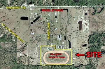
Property Record
1245 Mandy Ln, Astor, FL 32102
NEARBY LISTINGS FOR SALE OR LEASE
-
-
View all Astor listings for sale on LoopNet.com
Property Detail
1245 Mandy Ln
Deltona-Daytona Beach-Ormond Beach, FL
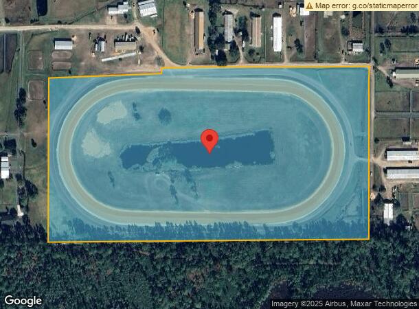
Reveille Farms Unrec Sub
5828-02-00-0230
28-15-28 RETENTION AREA & TROTTER TRACK UNNUMBERED LOT REVEILLE FARMS UNREC SUB #1507 PER OR 4588 PG 4514 PER OR 5427 PG 3138 PER OR 6294 PG 1466 PER OR 6294 PG 1469 PER OR 7274 PG 2033
Recreationalacreage
Volusia
X
Florida
12127C0275H
18a
2023
31.21 AC
2024
NW Volusia County
090102
Deltona/Daytona Beach
DEMOGRAPHICS near 1245 Mandy Ln
1 Mile
3 Mile
5 Mile
2024 Total Population
139
3,564
5,035
2029 Population
154
4,184
5,837
Pop Growth 2024-2029
+ 10.79%
+ 17.40%
+ 15.93%
Average Age
46
48
47
2024 Total Households
60
1,563
2,124
HH Growth 2024-2029
+ 10.00%
+ 17.27%
+ 16.10%
Median Household Inc
$65,000
$53,605
$54,111
Avg Household Size
2.30
2.20
2.30
2024 Avg HH Vehicles
2.00
2.00
2.00
Median Home Value
$299,999
$222,200
$231,764
Median Year Built
1979
1980
1980
Nearby Places
- Restaurants
- Banks
- Shops
- Fitness
- Groceries
PUBLIC TRANSPORTATION
AIRPORT
Daytona Beach International
DRIVE
WALK
Distance
Daytona Beach International
49 min
34.2 mi
Freight Ports
Port Canaveral
DRIVE
WALK
Distance
Port Canaveral
122 min
96.4 mi
Nearby Properties
Address
Land Use
TOTAL SIZE
Lot Size
Zoning
Address
Land Use
TOTAL SIZE
Lot Size
Zoning
605.83 AC
A
Address
Land Use
TOTAL SIZE
Lot Size
Zoning
491.13 AC
A
Address
Land Use
TOTAL SIZE
Lot Size
Zoning
639.34 AC
A
Address
Land Use
TOTAL SIZE
Lot Size
Zoning
387.93 AC
A
Address
Land Use
TOTAL SIZE
Lot Size
Zoning
18,998 SF
2.33 AC
B7
Address
Land Use
TOTAL SIZE
Lot Size
Zoning
397.63 AC
A
Address
Land Use
TOTAL SIZE
Lot Size
Zoning
637.73 AC
A
Address
Land Use
TOTAL SIZE
Lot Size
Zoning
641.17 AC
A
Address
Land Use
TOTAL SIZE
Lot Size
Zoning
626.60 AC
A
Address
Land Use
TOTAL SIZE
Lot Size
Zoning
384.69 AC
A
Address
Land Use
TOTAL SIZE
Lot Size
Zoning
4,806.35 AC
A
Address
Land Use
TOTAL SIZE
Lot Size
Zoning
589.68 AC
A
Address
Land Use
TOTAL SIZE
Lot Size
Zoning
632.83 AC
A
Address
Land Use
TOTAL SIZE
Lot Size
Zoning
594.69 AC
A
Address
Land Use
TOTAL SIZE
Lot Size
Zoning
571.72 AC
A
Address
Land Use
TOTAL SIZE
Lot Size
Zoning
560.44 AC
A
Address
Land Use
TOTAL SIZE
Lot Size
Zoning
563.26 AC
A
Address
Land Use
TOTAL SIZE
Lot Size
Zoning
23,264 SF
2.46 AC
CFD
Address
Land Use
TOTAL SIZE
Lot Size
Zoning
490.38 AC
A
Address
Land Use
TOTAL SIZE
Lot Size
Zoning
3,812 SF
19.24 AC
01B7
Address
Land Use
TOTAL SIZE
Lot Size
Zoning
14,088 SF
7.10 AC
01B7
Address
Land Use
TOTAL SIZE
Lot Size
Zoning
2,247 SF
11.08 AC
A
Address
Land Use
TOTAL SIZE
Lot Size
Zoning
416.10 AC
A
Address
Land Use
TOTAL SIZE
Lot Size
Zoning
1,105.55 AC
A
Address
Land Use
TOTAL SIZE
Lot Size
Zoning
403.32 AC
A
Address
Land Use
TOTAL SIZE
Lot Size
Zoning
210 AC
A
Address
Land Use
TOTAL SIZE
Lot Size
Zoning
28.42 AC
A2
Address
Land Use
TOTAL SIZE
Lot Size
Zoning
715.31 AC
FR
Address
Land Use
TOTAL SIZE
Lot Size
Zoning
625.80 AC
A
Address
Land Use
TOTAL SIZE
Lot Size
Zoning
8,400 SF
446.22 AC
A
The World's #1 Commercial Real Estate Marketplace
Connect with us
© 2025 CoStar Group
The information above has been obtained from sources believed reliable. While we do not doubt its accuracy we have not verified it and make no guarantee, warranty or representation about it. It is your responsibility to independently confirm its accuracy and completeness. Any projections, opinions, assumptions, or estimates used are for example only and do not represent the current or future performance of the property. The value of this transaction to you depends on tax and other factors which should be evaluated by your tax, financial, and legal advisors. You and your advisors should conduct a careful, independent investigation of the property to determine to your satisfaction the suitability of the property for your needs.