Property Record
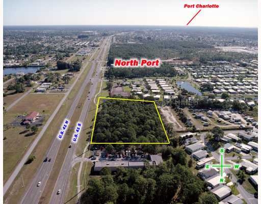
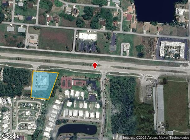
12480 Tamiami Trl S, North Port, FL 34287
NEARBY LISTINGS FOR SALE OR LEASE
Property Detail
12480 Tamiami Trl S
0791-05-0001
Not Part Of A Subdivision
Medicalbuilding
COM NW COR SEC 36-39-20 TH S 00-03-00 E ALONG W LINE OF SAID SEC 36 A DISTANCE OF 489.98 FT TO S R/W LINE OF US 41, SR 45 (TAMIAMI TRAIL) TH S 85-11-27 E ALONG SAID R/W LINE 1405.77 FT FOR
AE
Sarasota
12115C0370G
Florida
2023
1.68 AC
2024
Sarasota Outlying
002723
Tampa/St Petersburg
6,401 SF
North Port-Sarasota-Bradenton, FL
DEMOGRAPHICS near 12480 Tamiami Trl S
1 Mile
3 Mile
5 Mile
2024 Total Population
6,662
24,130
56,032
2029 Population
7,709
27,806
64,995
Pop Growth 2024-2029
+ 15.72%
+ 15.23%
+ 16.00%
Average Age
61
52
50
2024 Total Households
3,556
11,269
24,357
HH Growth 2024-2029
+ 15.80%
+ 15.28%
+ 16.12%
Median Household Inc
$45,762
$52,752
$68,144
Avg Household Size
1.90
2.10
2.30
2024 Avg HH Vehicles
1.00
1.00
2.00
Median Home Value
$146,437
$188,353
$258,146
Median Year Built
1982
1986
2000
Nearby Places
- Restaurants
- Banks
- Shops
- Fitness
- Groceries
PUBLIC TRANSPORTATION
AIRPORT
Punta Gorda
DRIVE
WALK
Distance
Punta Gorda
36 min
20.3 mi
Sarasota/Bradenton International
DRIVE
WALK
Distance
Sarasota/Bradenton International
53 min
38.8 mi
Freight Ports
Port Manatee
DRIVE
WALK
Distance
Port Manatee
66 min
51.3 mi
Nearby Properties
Address
Land Use
TOTAL SIZE
Lot Size
Zoning
Address
Land Use
TOTAL SIZE
Lot Size
Zoning
521,450 SF
196.98 AC
GU
Address
Land Use
TOTAL SIZE
Lot Size
Zoning
285,151 SF
26.73 AC
V
Address
Land Use
TOTAL SIZE
Lot Size
Zoning
104,383 SF
47.54 AC
GU
Address
Land Use
TOTAL SIZE
Lot Size
Zoning
155,080 SF
8.96 AC
CG
Address
Land Use
TOTAL SIZE
Lot Size
Zoning
101,676 SF
8.83 AC
AC1
Address
Land Use
TOTAL SIZE
Lot Size
Zoning
196,163 SF
15.60 AC
AC1
Address
Land Use
TOTAL SIZE
Lot Size
Zoning
115,678 SF
8.58 AC
R3
Address
Land Use
TOTAL SIZE
Lot Size
Zoning
142,364 SF
13.87 AC
AC1
Address
Land Use
TOTAL SIZE
Lot Size
Zoning
152.70 AC
AC8
Address
Land Use
TOTAL SIZE
Lot Size
Zoning
40,161 SF
40 AC
GU
Address
Land Use
TOTAL SIZE
Lot Size
Zoning
85,529 SF
11.41 AC
AC1
Address
Land Use
TOTAL SIZE
Lot Size
Zoning
94.16 AC
V
Address
Land Use
TOTAL SIZE
Lot Size
Zoning
106.85 AC
V
Address
Land Use
TOTAL SIZE
Lot Size
Zoning
42,923 SF
403.06 AC
R1
Address
Land Use
TOTAL SIZE
Lot Size
Zoning
63,016 SF
2.56 AC
AC1
Address
Land Use
TOTAL SIZE
Lot Size
Zoning
14,714 SF
81.28 AC
AC7B
Address
Land Use
TOTAL SIZE
Lot Size
Zoning
29,890 SF
7.78 AC
RMF
Address
Land Use
TOTAL SIZE
Lot Size
Zoning
50.35 AC
AC1
Address
Land Use
TOTAL SIZE
Lot Size
Zoning
41,054 SF
5.66 AC
CNP
Address
Land Use
TOTAL SIZE
Lot Size
Zoning
50,032 SF
10.06 AC
AC1
Address
Land Use
TOTAL SIZE
Lot Size
Zoning
26,467 SF
5.02 AC
GU
Address
Land Use
TOTAL SIZE
Lot Size
Zoning
155,647 SF
17.34 AC
V
Address
Land Use
TOTAL SIZE
Lot Size
Zoning
23.63 AC
V
Address
Land Use
TOTAL SIZE
Lot Size
Zoning
49,406 SF
9.24 AC
AC1
Address
Land Use
TOTAL SIZE
Lot Size
Zoning
15,018 SF
2.25 AC
AC1
Address
Land Use
TOTAL SIZE
Lot Size
Zoning
19,360 SF
2.28 AC
AC1
Address
Land Use
TOTAL SIZE
Lot Size
Zoning
4,013 SF
12.03 AC
AC1
Address
Land Use
TOTAL SIZE
Lot Size
Zoning
7,690 SF
20.86 AC
V
Address
Land Use
TOTAL SIZE
Lot Size
Zoning
11,480 SF
1.88 AC
AC1
Address
Land Use
TOTAL SIZE
Lot Size
Zoning
2,010 SF
45 AC
AC8
The World's #1 Commercial Real Estate Marketplace
Connect with us
© 2025 CoStar Group
The information above has been obtained from sources believed reliable. While we do not doubt its accuracy we have not verified it and make no guarantee, warranty or representation about it. It is your responsibility to independently confirm its accuracy and completeness. Any projections, opinions, assumptions, or estimates used are for example only and do not represent the current or future performance of the property. The value of this transaction to you depends on tax and other factors which should be evaluated by your tax, financial, and legal advisors. You and your advisors should conduct a careful, independent investigation of the property to determine to your satisfaction the suitability of the property for your needs.