Property Record
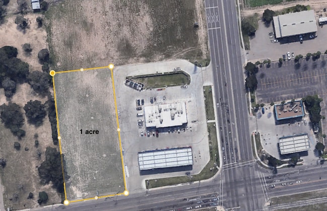
Highway 83, Mcallen, TX 78501


Property Detail
Highway 83
McAllen/Edinburg/Pharr
KINGS HIGHWAY AN IRR TR N637-W157.80 LOT 6 & N745.05 LOT 7 EXC AN IRR TR N339.94-W131.07 & S262.03-N587.55 LOT 8 5.16AC NET
McAllen-Edinburg-Mission, TX
HIDALGO
K7200-00-000-0006-02
Texas
Agriculturalland
6
2024
5.16 AC
2025
Greater McAllen
021003
NEARBY LISTINGS FOR SALE OR LEASE
DEMOGRAPHICS near Highway 83
1 mile
3 mile
5 mile
2025 Total Population
9,534
96,116
222,907
2030 Population
9,970
100,604
233,210
Pop Growth 2025-2030
+ 4.57%
+ 4.67%
+ 4.62%
Average Age
38
38
37
2025 Total Households
3,153
32,891
75,011
HH Growth 2025-2030
+ 4.41%
+ 4.72%
+ 4.60%
Median Household Inc
$41,026
$54,597
$59,235
Avg Household Size
2.80
2.80
2.90
2025 Avg HH Vehicles
2.00
2.00
2.00
Median Home Value
$113,663
$182,572
$187,645
Median Year Built
1991
1993
1995
Nearby Places
Map Layers
Map Styles
 Street
 Aerial
Layers
 Traffic
 Biking
Places
Listings with unknown addresses are not visible on the map
- Restaurants
- Banks
- Shops
- Fitness
- Groceries
PUBLIC TRANSPORTATION
AIRPORT
McAllen International
Drive
Walk
Distance
McAllen International
8 min
3.7 mi
Freight Ports
Port of Brownsville
Drive
Walk
Distance
Port of Brownsville
72 min
62.7 mi
SALE & LEASE HISTORY
LISTING DATE
SALE/LEASE

Oct 10, 2018
For Sale
Jun 02, 2020
For Sale
Feb 19, 2020
For Sale
Nearby Properties
Address
Land Use
TOTAL SIZE
Lot Size
Zoning
Address
Land Use
TOTAL SIZE
Lot Size
Zoning
1,199,590 SF
47.93 AC
Address
Land Use
TOTAL SIZE
Lot Size
Zoning
430,216 SF
18.66 AC
CO
Address
Land Use
TOTAL SIZE
Lot Size
Zoning
347,628 SF
13.03 AC
CO
Address
Land Use
TOTAL SIZE
Lot Size
Zoning
291,859 SF
10.11 AC
CO
Address
Land Use
TOTAL SIZE
Lot Size
Zoning
165,620 SF
24.44 AC
Address
Land Use
TOTAL SIZE
Lot Size
Zoning
93,471 SF
12.66 AC
Address
Land Use
TOTAL SIZE
Lot Size
Zoning
18 SF
82.24 AC
Address
Land Use
TOTAL SIZE
Lot Size
Zoning
354,558 SF
26.79 AC
Address
Land Use
TOTAL SIZE
Lot Size
Zoning
263,388 SF
37.48 AC
Address
Land Use
TOTAL SIZE
Lot Size
Zoning
235,545 SF
40.51 AC
Address
Land Use
TOTAL SIZE
Lot Size
Zoning
191,978 SF
2.22 AC
Address
Land Use
TOTAL SIZE
Lot Size
Zoning
252,435 SF
9.09 AC
Address
Land Use
TOTAL SIZE
Lot Size
Zoning
216,315 SF
3.19 AC
CO
Address
Land Use
TOTAL SIZE
Lot Size
Zoning
208,941 SF
18.57 AC
Address
Land Use
TOTAL SIZE
Lot Size
Zoning
159,617 SF
5.38 AC
Address
Land Use
TOTAL SIZE
Lot Size
Zoning
236,124 SF
14.03 AC
Address
Land Use
TOTAL SIZE
Lot Size
Zoning
125,254 SF
15 AC
C
Address
Land Use
TOTAL SIZE
Lot Size
Zoning
208,113 SF
22.75 AC
Address
Land Use
TOTAL SIZE
Lot Size
Zoning
3,000 SF
16 AC
Address
Land Use
TOTAL SIZE
Lot Size
Zoning
115,360 SF
4.70 AC
Address
Land Use
TOTAL SIZE
Lot Size
Zoning
156,516 SF
13.65 AC
Address
Land Use
TOTAL SIZE
Lot Size
Zoning
108,527 SF
1.49 AC
Address
Land Use
TOTAL SIZE
Lot Size
Zoning
177,334 SF
10.31 AC
Address
Land Use
TOTAL SIZE
Lot Size
Zoning
100,318 SF
3.65 AC
Address
Land Use
TOTAL SIZE
Lot Size
Zoning
59,078 SF
12.65 AC
CO
Address
Land Use
TOTAL SIZE
Lot Size
Zoning
59,816 SF
2.42 AC
Address
Land Use
TOTAL SIZE
Lot Size
Zoning
95,245 SF
8.92 AC
C-3
Address
Land Use
TOTAL SIZE
Lot Size
Zoning
69,184 SF
2.94 AC
Address
Land Use
TOTAL SIZE
Lot Size
Zoning
54,270 SF
29 AC
Address
Land Use
TOTAL SIZE
Lot Size
Zoning
78,808 SF
3.72 AC
The World's #1 Commercial Real Estate Marketplace
Connect with us
© 2026 CoStar Group
The information above has been obtained from sources believed reliable. While we do not doubt its accuracy we have not verified it and make no guarantee, warranty or representation about it. It is your responsibility to independently confirm its accuracy and completeness. Any projections, opinions, assumptions, or estimates used are for example only and do not represent the current or future performance of the property. The value of this transaction to you depends on tax and other factors which should be evaluated by your tax, financial, and legal advisors. You and your advisors should conduct a careful, independent investigation of the property to determine to your satisfaction the suitability of the property for your needs.