Property Record
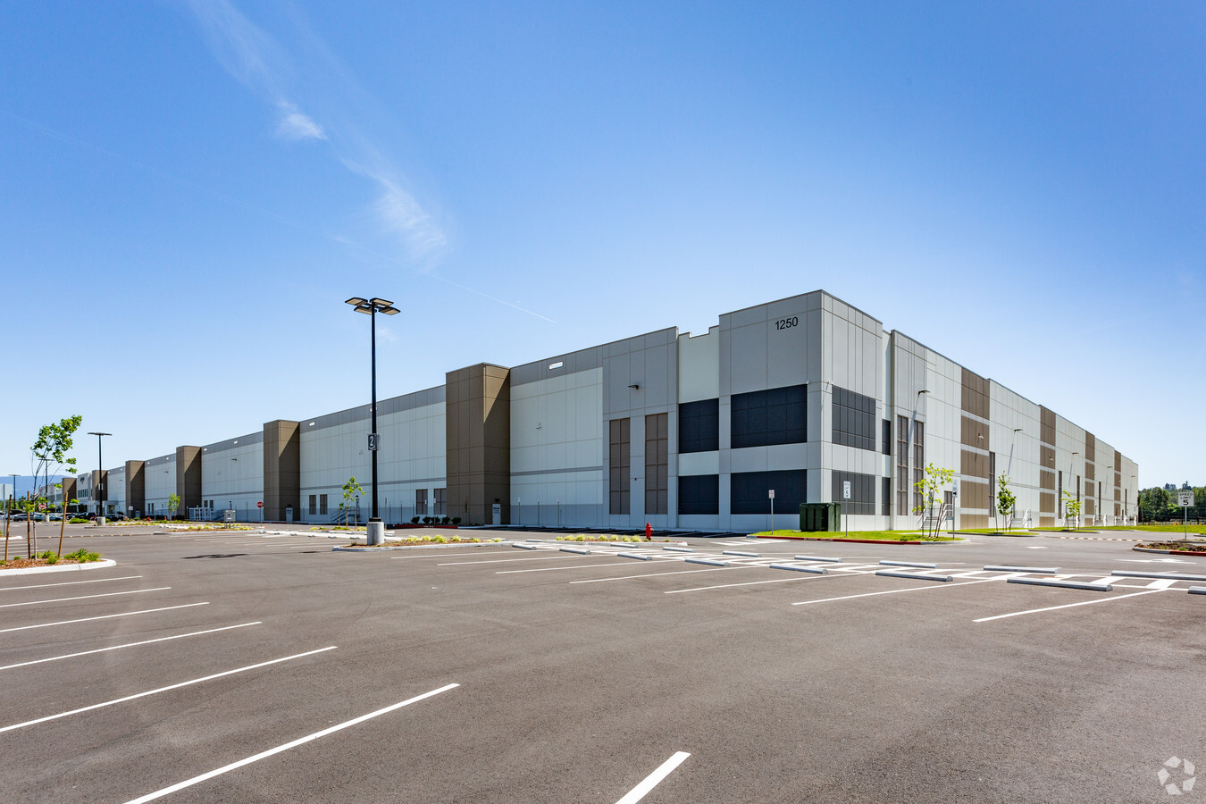
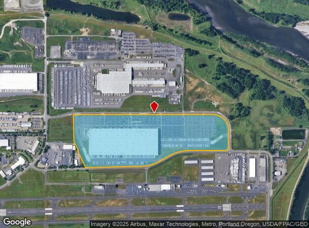
1250 Nw Swigert Way, Troutdale, OR 97060
NEARBY LISTINGS FOR SALE OR LEASE
Property Detail
1250 Nw Swigert Way
Portland
Troutdale Reynolds Industrial Park No 2
Portland-Vancouver-Hillsboro, OR-WA
TROUTDALE REYNOLDS INDUSTRIAL PARK NO 2, LOT 6-8 TL 115, LAND & IMPS SEE R697626 (R843610201) FOR MACH & EQUIP, ENTERPRISE ZONE, POTENTIAL ADDITIONAL TAX
R680569
Multnomah
Industrialgeneral
Oregon
2023
6-8
2023
73.72 AC
010200
East Columbia Corridor
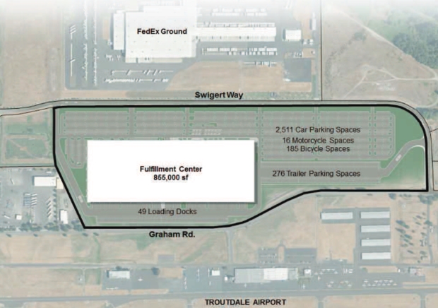
857,470 SF
DEMOGRAPHICS near 1250 Nw Swigert Way
1 Mile
3 Mile
5 Mile
2024 Total Population
345
49,436
168,589
2029 Population
342
49,434
169,657
Pop Growth 2024-2029
(0.87%)
0.00%
+ 0.63%
Average Age
38
40
39
2024 Total Households
150
18,137
60,446
HH Growth 2024-2029
(1.33%)
(0.20%)
+ 0.38%
Median Household Inc
$67,840
$73,656
$73,544
Avg Household Size
2.30
2.70
2.70
2024 Avg HH Vehicles
2.00
2.00
2.00
Median Home Value
$408,333
$397,464
$418,240
Median Year Built
1992
1988
1987
Nearby Places
- Restaurants
- Banks
- Shops
- Fitness
- Groceries
PUBLIC TRANSPORTATION
AIRPORT
Portland International
DRIVE
WALK
Distance
Portland International
21 min
10.7 mi
Freight Ports
Port of Portland
DRIVE
WALK
Distance
Port of Portland
29 min
19.5 mi
Nearby Properties
Address
Land Use
TOTAL SIZE
Lot Size
Zoning
Address
Land Use
TOTAL SIZE
Lot Size
Zoning
3,800 SF
25.11 AC
LI
Address
Land Use
TOTAL SIZE
Lot Size
Zoning
40.81 AC
LDR-5
Address
Land Use
TOTAL SIZE
Lot Size
Zoning
1,500,000 SF
189.27 AC
HI
Address
Land Use
TOTAL SIZE
Lot Size
Zoning
8.69 AC
GI
Address
Land Use
TOTAL SIZE
Lot Size
Zoning
477,326 SF
77.86 AC
GI
Address
Land Use
TOTAL SIZE
Lot Size
Zoning
302,114 SF
31.69 AC
R-5
Address
Land Use
TOTAL SIZE
Lot Size
Zoning
Address
Land Use
TOTAL SIZE
Lot Size
Zoning
836,366 SF
38.86 AC
LI
Address
Land Use
TOTAL SIZE
Lot Size
Zoning
219,470 SF
9.77 AC
R_MF
Address
Land Use
TOTAL SIZE
Lot Size
Zoning
197,834 SF
8.67 AC
R5
Address
Land Use
TOTAL SIZE
Lot Size
Zoning
14,059 SF
12.83 AC
GI
Address
Land Use
TOTAL SIZE
Lot Size
Zoning
224,500 SF
12.30 AC
R-7.5
Address
Land Use
TOTAL SIZE
Lot Size
Zoning
114,696 SF
2.29 AC
MF-18
Address
Land Use
TOTAL SIZE
Lot Size
Zoning
273,264 SF
11.39 AC
CMF
Address
Land Use
TOTAL SIZE
Lot Size
Zoning
156,393 SF
5.82 AC
GC
Address
Land Use
TOTAL SIZE
Lot Size
Zoning
142,571 SF
1.73 AC
TC-C
Address
Land Use
TOTAL SIZE
Lot Size
Zoning
118,460 SF
28.10 AC
BP
Address
Land Use
TOTAL SIZE
Lot Size
Zoning
304,649 SF
14.13 AC
GI
Address
Land Use
TOTAL SIZE
Lot Size
Zoning
140,587 SF
9.73 AC
R_MF
Address
Land Use
TOTAL SIZE
Lot Size
Zoning
194,991 SF
5.56 AC
TCC
Address
Land Use
TOTAL SIZE
Lot Size
Zoning
19.55 AC
GI
Address
Land Use
TOTAL SIZE
Lot Size
Zoning
70,955 SF
4.78 AC
R/CSP
Address
Land Use
TOTAL SIZE
Lot Size
Zoning
65,461 SF
7.90 AC
LDR-5
Address
Land Use
TOTAL SIZE
Lot Size
Zoning
165,000 SF
14.35 AC
CC
Address
Land Use
TOTAL SIZE
Lot Size
Zoning
205,276 SF
7.46 AC
R/MF
Address
Land Use
TOTAL SIZE
Lot Size
Zoning
193,944 SF
11.27 AC
GI
Address
Land Use
TOTAL SIZE
Lot Size
Zoning
175,153 SF
4.90 AC
LM
Address
Land Use
TOTAL SIZE
Lot Size
Zoning
4,490 SF
75.54 AC
GI
Address
Land Use
TOTAL SIZE
Lot Size
Zoning
58,000 SF
21.71 AC
R/CSP
Address
Land Use
TOTAL SIZE
Lot Size
Zoning
The World's #1 Commercial Real Estate Marketplace
Connect with us
© 2025 CoStar Group
The information above has been obtained from sources believed reliable. While we do not doubt its accuracy we have not verified it and make no guarantee, warranty or representation about it. It is your responsibility to independently confirm its accuracy and completeness. Any projections, opinions, assumptions, or estimates used are for example only and do not represent the current or future performance of the property. The value of this transaction to you depends on tax and other factors which should be evaluated by your tax, financial, and legal advisors. You and your advisors should conduct a careful, independent investigation of the property to determine to your satisfaction the suitability of the property for your needs.