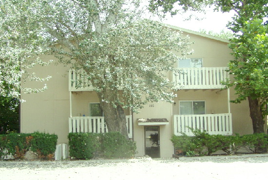
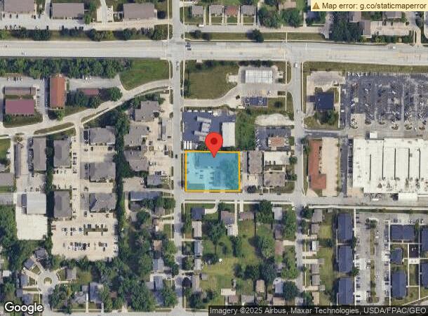
Property Record
126 Beedle Dr, Ames, IA 50014
NEARBY LISTINGS FOR SALE OR LEASE
Property Detail
126 Beedle Dr
Ames, IA
Beedle's Sd
09-08-125-080
BEEDLES SD BLOCK:1 LOT:6 AMES
Apartment
Story
X
Iowa
19015C0250D
6
2024
0.82 AC
2024
West Ames
001304
Other Market Areas
24,072 SF
DEMOGRAPHICS near 126 Beedle Dr
1 Mile
3 Mile
5 Mile
2024 Total Population
16,522
52,037
68,704
2029 Population
17,046
53,558
70,770
Pop Growth 2024-2029
+ 3.17%
+ 2.92%
+ 3.01%
Average Age
30
31
33
2024 Total Households
7,623
20,152
27,634
HH Growth 2024-2029
+ 3.28%
+ 3.43%
+ 3.40%
Median Household Inc
$47,426
$54,190
$58,205
Avg Household Size
2.10
2.10
2.10
2024 Avg HH Vehicles
2.00
2.00
2.00
Median Home Value
$264,831
$262,038
$251,620
Median Year Built
1996
1993
1990
Nearby Places
- Restaurants
- Banks
- Shops
- Fitness
- Groceries
Nearby Properties
Address
Land Use
TOTAL SIZE
Lot Size
Zoning
Address
Land Use
TOTAL SIZE
Lot Size
Zoning
54,112 SF
12.70 AC
Address
Land Use
TOTAL SIZE
Lot Size
Zoning
289,606 SF
1.77 AC
CSC
Address
Land Use
TOTAL SIZE
Lot Size
Zoning
3,485 SF
28.90 AC
Address
Land Use
TOTAL SIZE
Lot Size
Zoning
52,980 SF
8.52 AC
PI
Address
Land Use
TOTAL SIZE
Lot Size
Zoning
75,302 SF
16.66 AC
HOC
Address
Land Use
TOTAL SIZE
Lot Size
Zoning
82,734 SF
1.42 AC
CSC
Address
Land Use
TOTAL SIZE
Lot Size
Zoning
120,842 SF
26.68 AC
PI
Address
Land Use
TOTAL SIZE
Lot Size
Zoning
16,222 SF
10.44 AC
Address
Land Use
TOTAL SIZE
Lot Size
Zoning
117,797 SF
7.88 AC
Address
Land Use
TOTAL SIZE
Lot Size
Zoning
7,314 SF
8.91 AC
RH
Address
Land Use
TOTAL SIZE
Lot Size
Zoning
93,813 SF
7.11 AC
GI
Address
Land Use
TOTAL SIZE
Lot Size
Zoning
84,132 SF
3.57 AC
FS-RM
Address
Land Use
TOTAL SIZE
Lot Size
Zoning
188,204 SF
117.78 AC
A1
Address
Land Use
TOTAL SIZE
Lot Size
Zoning
133,668 SF
3.71 AC
RH
Address
Land Use
TOTAL SIZE
Lot Size
Zoning
54,066 SF
5.92 AC
RI
Address
Land Use
TOTAL SIZE
Lot Size
Zoning
20,619 SF
2.44 AC
RH
Address
Land Use
TOTAL SIZE
Lot Size
Zoning
920 SF
20.72 AC
F-PRD
Address
Land Use
TOTAL SIZE
Lot Size
Zoning
148,996 SF
11.50 AC
HOC
Address
Land Use
TOTAL SIZE
Lot Size
Zoning
97,767 SF
0.05 AC
CSC
Address
Land Use
TOTAL SIZE
Lot Size
Zoning
100,588 SF
7.65 AC
HOC
Address
Land Use
TOTAL SIZE
Lot Size
Zoning
63,021 SF
3.43 AC
Address
Land Use
TOTAL SIZE
Lot Size
Zoning
35,880 SF
3.97 AC
PI
Address
Land Use
TOTAL SIZE
Lot Size
Zoning
52,904 SF
2.13 AC
RH
Address
Land Use
TOTAL SIZE
Lot Size
Zoning
26.37 AC
SGA
Address
Land Use
TOTAL SIZE
Lot Size
Zoning
72,459 SF
3.06 AC
CCR
Address
Land Use
TOTAL SIZE
Lot Size
Zoning
49,699 SF
11.30 AC
PI
Address
Land Use
TOTAL SIZE
Lot Size
Zoning
105,550 SF
0.62 AC
CSC
Address
Land Use
TOTAL SIZE
Lot Size
Zoning
101,006 SF
14.35 AC
PI
Address
Land Use
TOTAL SIZE
Lot Size
Zoning
34,100 SF
2.93 AC
RI
Address
Land Use
TOTAL SIZE
Lot Size
Zoning
30,207 SF
4.81 AC
The World's #1 Commercial Real Estate Marketplace
Connect with us
© 2025 CoStar Group
The information above has been obtained from sources believed reliable. While we do not doubt its accuracy we have not verified it and make no guarantee, warranty or representation about it. It is your responsibility to independently confirm its accuracy and completeness. Any projections, opinions, assumptions, or estimates used are for example only and do not represent the current or future performance of the property. The value of this transaction to you depends on tax and other factors which should be evaluated by your tax, financial, and legal advisors. You and your advisors should conduct a careful, independent investigation of the property to determine to your satisfaction the suitability of the property for your needs.