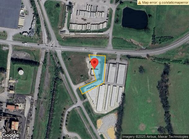
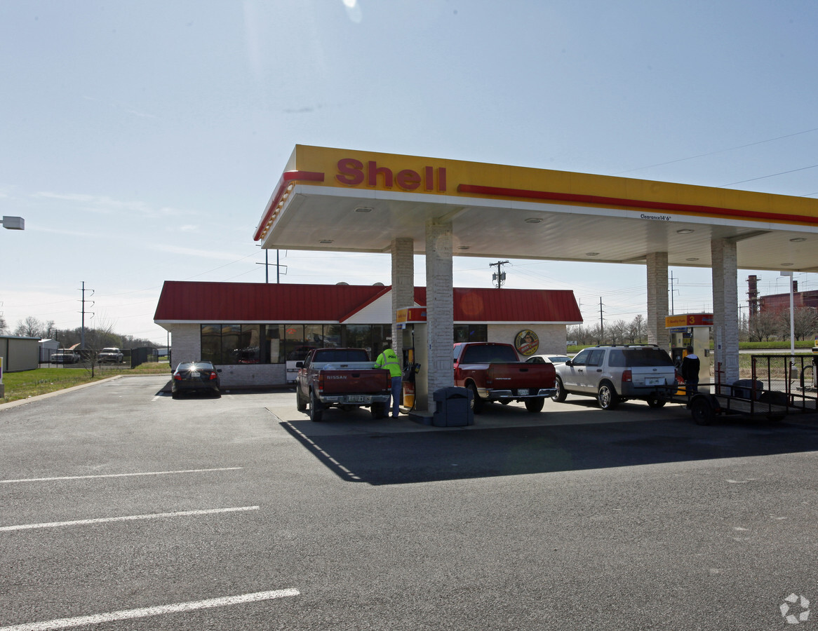
Property Record
1273 Airport Rd, Gallatin, TN 37066


NEARBY LISTINGS FOR SALE OR LEASE
Property Detail
1273 Airport Rd
Nashville-Davidson--Murfreesboro--Franklin, TN
Green Morgan Park
127-065.03
PLAT: 11 PAGE: 188 BLOCK: LOT: 2 SUBD: GREEN MORGAN PARK
Supermarket
Sumner
X
Tennessee
47165C0431G
2
2023
1 AC
2023
Hendersonville-Gallatin
020901
Nashville
3,500 SF
DEMOGRAPHICS near 1273 Airport Rd
1 Mile
3 Mile
5 Mile
2024 Total Population
1,666
28,267
49,365
2029 Population
1,850
31,544
55,401
Pop Growth 2024-2029
+ 11.04%
+ 11.59%
+ 12.23%
Average Age
37
39
41
2024 Total Households
656
10,910
19,243
HH Growth 2024-2029
+ 11.43%
+ 11.81%
+ 12.44%
Median Household Inc
$59,166
$49,095
$59,818
Avg Household Size
2.50
2.50
2.50
2024 Avg HH Vehicles
2.00
2.00
2.00
Median Home Value
$226,712
$253,821
$322,857
Median Year Built
1996
1985
1995
Nearby Places
- Restaurants
- Banks
- Shops
- Fitness
- Groceries
PUBLIC TRANSPORTATION
AIRPORT
Nashville International
DRIVE
WALK
Distance
Nashville International
41 min
32.1 mi
Freight Ports
Port of Toledo
DRIVE
WALK
Distance
Port of Toledo
527 min
463.4 mi
SALE & LEASE HISTORY
LISTING DATE
SALE/LEASE

Oct 11, 2017
For Sale
Nov 20, 2018
For Sale
Nearby Properties
Address
Land Use
TOTAL SIZE
Lot Size
Zoning
Address
Land Use
TOTAL SIZE
Lot Size
Zoning
82,479 SF
28.56 AC
IR
Address
Land Use
TOTAL SIZE
Lot Size
Zoning
52,475 SF
14.46 AC
Address
Land Use
TOTAL SIZE
Lot Size
Zoning
8,736 SF
15.77 AC
Address
Land Use
TOTAL SIZE
Lot Size
Zoning
127,050 SF
Address
Land Use
TOTAL SIZE
Lot Size
Zoning
35,569 SF
6.99 AC
Address
Land Use
TOTAL SIZE
Lot Size
Zoning
10,320 SF
76.70 AC
IG
Address
Land Use
TOTAL SIZE
Lot Size
Zoning
64,960 SF
15.11 AC
IG
Address
Land Use
TOTAL SIZE
Lot Size
Zoning
106,660 SF
18.74 AC
IG
Address
Land Use
TOTAL SIZE
Lot Size
Zoning
9,568 SF
16.50 AC
Address
Land Use
TOTAL SIZE
Lot Size
Zoning
14,016 SF
13.91 AC
IR
Address
Land Use
TOTAL SIZE
Lot Size
Zoning
426,312 SF
40 AC
IG
Address
Land Use
TOTAL SIZE
Lot Size
Zoning
64,000 SF
23.76 AC
IG
Address
Land Use
TOTAL SIZE
Lot Size
Zoning
70,889 SF
4.26 AC
Address
Land Use
TOTAL SIZE
Lot Size
Zoning
55,928 SF
5.73 AC
Address
Land Use
TOTAL SIZE
Lot Size
Zoning
50,000 SF
8.37 AC
IR
Address
Land Use
TOTAL SIZE
Lot Size
Zoning
41,239 SF
2.23 AC
Address
Land Use
TOTAL SIZE
Lot Size
Zoning
89,860 SF
7.72 AC
Address
Land Use
TOTAL SIZE
Lot Size
Zoning
1,300 SF
4.65 AC
Address
Land Use
TOTAL SIZE
Lot Size
Zoning
65,933 SF
4.27 AC
Address
Land Use
TOTAL SIZE
Lot Size
Zoning
24,919 SF
1.11 AC
Address
Land Use
TOTAL SIZE
Lot Size
Zoning
18,461 SF
1.72 AC
Address
Land Use
TOTAL SIZE
Lot Size
Zoning
77,070 SF
6.91 AC
IG
Address
Land Use
TOTAL SIZE
Lot Size
Zoning
22,628 SF
2.05 AC
Address
Land Use
TOTAL SIZE
Lot Size
Zoning
5.44 AC
IR
Address
Land Use
TOTAL SIZE
Lot Size
Zoning
157,084 SF
6.17 AC
Address
Land Use
TOTAL SIZE
Lot Size
Zoning
40,000 SF
8.81 AC
IR
Address
Land Use
TOTAL SIZE
Lot Size
Zoning
44,674 SF
13.30 AC
Address
Land Use
TOTAL SIZE
Lot Size
Zoning
370,211 SF
28.30 AC
Address
Land Use
TOTAL SIZE
Lot Size
Zoning
24,570 SF
1.50 AC
Address
Land Use
TOTAL SIZE
Lot Size
Zoning
33,686 SF
6.22 AC
The World's #1 Commercial Real Estate Marketplace
Connect with us
© 2025 CoStar Group
The information above has been obtained from sources believed reliable. While we do not doubt its accuracy we have not verified it and make no guarantee, warranty or representation about it. It is your responsibility to independently confirm its accuracy and completeness. Any projections, opinions, assumptions, or estimates used are for example only and do not represent the current or future performance of the property. The value of this transaction to you depends on tax and other factors which should be evaluated by your tax, financial, and legal advisors. You and your advisors should conduct a careful, independent investigation of the property to determine to your satisfaction the suitability of the property for your needs.