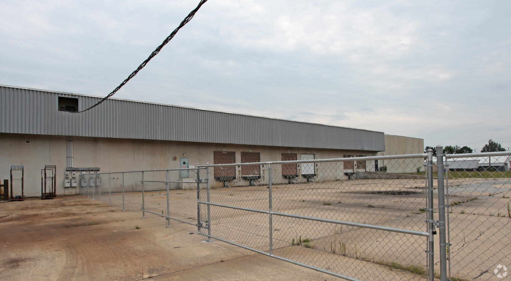
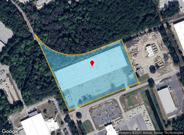
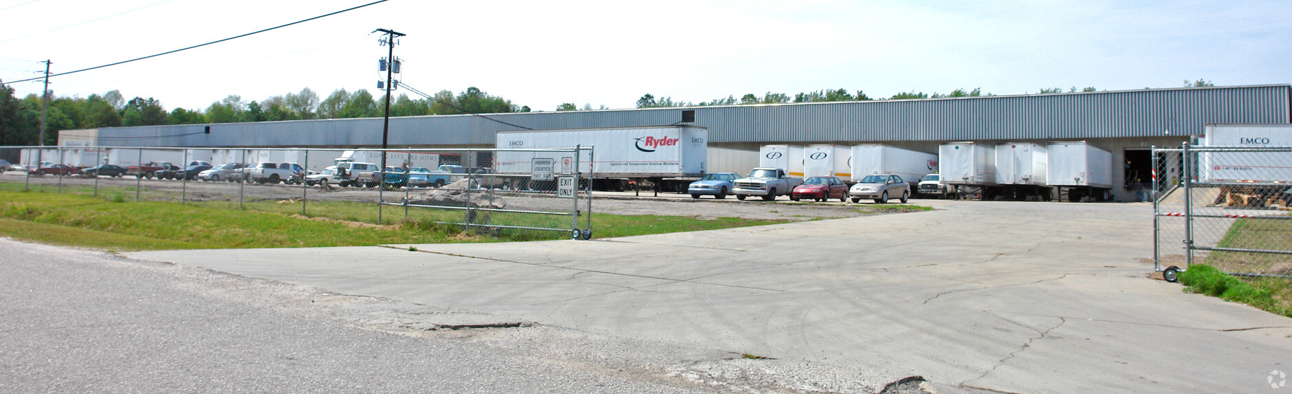
Property Record
128 Mcqueen St, West Columbia, SC 29172
NEARBY LISTINGS FOR SALE OR LEASE
Property Detail
128 Mcqueen St
006896-03-015
PARCEL 21
Warehouse
Lexington
X
South Carolina
45063C0286J
10.61 AC
0
Cayce/West Columbia
2024
Columbia
020605
Columbia, SC
181,060 SF
DEMOGRAPHICS near 128 Mcqueen St
1 Mile
3 Mile
5 Mile
2024 Total Population
1,027
18,542
72,877
2029 Population
1,110
20,187
79,502
Pop Growth 2024-2029
+ 8.08%
+ 8.87%
+ 9.09%
Average Age
40
41
39
2024 Total Households
453
8,022
31,112
HH Growth 2024-2029
+ 8.17%
+ 9.03%
+ 9.34%
Median Household Inc
$45,345
$55,568
$53,952
Avg Household Size
2.20
2.30
2.20
2024 Avg HH Vehicles
2.00
2.00
2.00
Median Home Value
$128,758
$148,162
$151,352
Median Year Built
1980
1973
1980
Nearby Places
- Restaurants
- Banks
- Shops
- Fitness
- Groceries
PUBLIC TRANSPORTATION
COMMUTER RAIL
Columbia Amtrak Station (Silver Star - Amtrak)
DRIVE
WALK
Distance
Columbia Amtrak Station (Silver Star - Amtrak)
15 min
7.1 mi
AIRPORT
Columbia Metro
DRIVE
WALK
Distance
Columbia Metro
14 min
3.5 mi
Freight Ports
North Charleston Terminal
DRIVE
WALK
Distance
North Charleston Terminal
117 min
100.7 mi
SALE & LEASE HISTORY
LISTING DATE
SALE/LEASE

Oct 25, 2017
For Lease
Jul 17, 2019
For Lease
Nearby Properties
Address
Land Use
TOTAL SIZE
Lot Size
Zoning
Address
Land Use
TOTAL SIZE
Lot Size
Zoning
1,253,820 SF
87.15 AC
Address
Land Use
TOTAL SIZE
Lot Size
Zoning
461,888 SF
61.50 AC
ID
Address
Land Use
TOTAL SIZE
Lot Size
Zoning
3,614 SF
1,444.32 AC
ID
Address
Land Use
TOTAL SIZE
Lot Size
Zoning
466,400 SF
52.42 AC
ID
Address
Land Use
TOTAL SIZE
Lot Size
Zoning
1,218 SF
8.99 AC
RG
Address
Land Use
TOTAL SIZE
Lot Size
Zoning
8,118 SF
10.98 AC
RG
Address
Land Use
TOTAL SIZE
Lot Size
Zoning
180,000 SF
27.57 AC
ID
Address
Land Use
TOTAL SIZE
Lot Size
Zoning
10,304 SF
11.89 AC
R1
Address
Land Use
TOTAL SIZE
Lot Size
Zoning
9,800 SF
13.52 AC
ID
Address
Land Use
TOTAL SIZE
Lot Size
Zoning
5,502 SF
16.15 AC
ID
Address
Land Use
TOTAL SIZE
Lot Size
Zoning
318,309 SF
33.51 AC
ID
Address
Land Use
TOTAL SIZE
Lot Size
Zoning
200,000 SF
10.58 AC
ID
Address
Land Use
TOTAL SIZE
Lot Size
Zoning
200,000 SF
9.66 AC
ID
Address
Land Use
TOTAL SIZE
Lot Size
Zoning
279,568 SF
11.38 AC
ID
Address
Land Use
TOTAL SIZE
Lot Size
Zoning
430.11 AC
ID
Address
Land Use
TOTAL SIZE
Lot Size
Zoning
254,399 SF
49.79 AC
ID
Address
Land Use
TOTAL SIZE
Lot Size
Zoning
202,029 SF
21.13 AC
ID
Address
Land Use
TOTAL SIZE
Lot Size
Zoning
215,770 SF
24.51 AC
Address
Land Use
TOTAL SIZE
Lot Size
Zoning
50,400 SF
11 AC
ID
Address
Land Use
TOTAL SIZE
Lot Size
Zoning
92.08 AC
Address
Land Use
TOTAL SIZE
Lot Size
Zoning
14,602 SF
2.41 AC
C2
Address
Land Use
TOTAL SIZE
Lot Size
Zoning
90,736 SF
9.73 AC
C3
Address
Land Use
TOTAL SIZE
Lot Size
Zoning
73,778 SF
4.95 AC
A
Address
Land Use
TOTAL SIZE
Lot Size
Zoning
17,442 SF
2.78 AC
Address
Land Use
TOTAL SIZE
Lot Size
Zoning
53,356 SF
6.16 AC
C2
Address
Land Use
TOTAL SIZE
Lot Size
Zoning
54,092 SF
5.90 AC
ID
Address
Land Use
TOTAL SIZE
Lot Size
Zoning
9,444 SF
13.72 AC
M1
Address
Land Use
TOTAL SIZE
Lot Size
Zoning
28,210 SF
9.54 AC
Address
Land Use
TOTAL SIZE
Lot Size
Zoning
41,656 SF
5.66 AC
C2
Address
Land Use
TOTAL SIZE
Lot Size
Zoning
101,054 SF
8.94 AC
C2
The World's #1 Commercial Real Estate Marketplace
Connect with us
© 2025 CoStar Group
The information above has been obtained from sources believed reliable. While we do not doubt its accuracy we have not verified it and make no guarantee, warranty or representation about it. It is your responsibility to independently confirm its accuracy and completeness. Any projections, opinions, assumptions, or estimates used are for example only and do not represent the current or future performance of the property. The value of this transaction to you depends on tax and other factors which should be evaluated by your tax, financial, and legal advisors. You and your advisors should conduct a careful, independent investigation of the property to determine to your satisfaction the suitability of the property for your needs.